San Pedro Garza Garcia elevation
San Pedro Garza Garcia (Nuevo León, San Pedro Garza García), Mexico elevation is 663 meters and San Pedro Garza Garcia elevation in feet is 2175 ft above sea level [src 1]. San Pedro Garza Garcia is a populated place (feature code) with elevation that is 651 meters (2136 ft) smaller than average city elevation in Mexico.
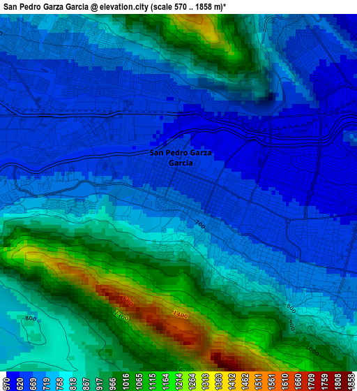
Below is the Elevation map of San Pedro Garza Garcia, which displays elevation range with different colors. Scale of the first map is from 570 to 1858 m (1870 to 6096 ft) with average elevation of 811.9 meters (=2664 ft) [note 1]
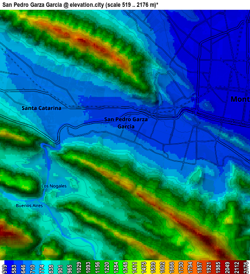
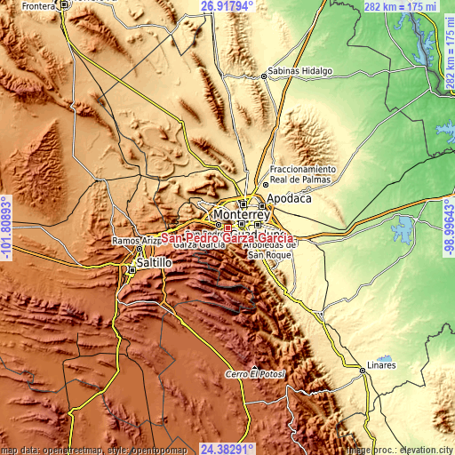
These maps also provides idea of topography and contour of this city, they are displayed at different zoom levels. More info about maps, scale and edge coordinates you can find below images.
| \ | Map #1 | Map #2 | Topo.Map |
| Scale [m] | 570..1858 m | 519..2176 m | × |
| Scale [ft] | 1870..6096 ft | 1703..7139 ft | × |
| Average | 811.9 m = 2664 ft | 896.8 m = 2942 ft | × |
| Width | 8.81 km = 5.5 mi | 17.62 km = 10.9 mi | 281.9 km = 175.2 mi |
| Height | 8.81 km = 5.5 mi | 17.62 km = 10.9 mi | 281.9 km = 175.2 mi |
| ↑Max Latitude | 25.696766° | 25.736358° | 26.91794° |
| Latitude at center | 25.65716° | 25.65716° | 25.65716° |
| ↓Min Latitude | 25.617541° | 25.577909° | 24.38291° |
| ← Min Longitude | -100.446625° | -100.490571° | -101.80893° |
| Longitude center | -100.40268° | -100.40268° | -100.40268° |
| →Max Longitude | -100.358735° | -100.314789° | -98.99643° |
Nearby cities:
Cities around San Pedro Garza Garcia sort by population:
• Monterrey elevation 543 m
8.7 km,  76°
76°
• Guadalupe 497 m
14.8 km, 81°
• San Nicolás de los Garza 510 m
13.8 km,  46°
46°
• Ciudad General Escobedo 499 m
17.7 km,  28°
28°
• Santa Catarina 675 m
5.8 km,  287°
287°
• San Pedro Garza García 656 m
0.5 km,  313°
313°
• Parque Industrial Ciudad Mitras 593 m
15.3 km,  342°
342°
• Mitras Poniente 592 m
13.4 km,  350°
350°
• Valle de Lincoln 617 m
16.9 km,  333°
333°
• Los Parques 619 m
16.3 km, 335°
• Monclova Primer Sector 557 m
17.5 km,  359°
359°
• Monclova Segundo Sector 554 m
17.6 km,  1°
1°
Multilingual:
 En español:
San Pedro Garza García elevación 663 m.
 En France:
San Pedro Garza Garcia élévation 663 m.
 Auf Deutsch:
San Pedro Garza Garcia höhe über dem Meeresspiegel ist 663 m.
 На русском:
San Pedro Garza Garcia высота над уровнем моря 663 м
Sources and notes:
- [note 1] Map square and city borders are not equal. Map elevation data is calculated only from area inside that square.
- [src 1] Elevation data from geonames database provided with same terms of usage.
- [src 2] The elevation map of San Pedro Garza Garcia is generated using elevation data from NASA's 3 arcsec (90m) resolution SRTM data.
- [src 3] Base (background) map © OpenStreetMap contributors tiles are generated by Geofabrik and OpenTopoMap.
Copyright & License:
This San Pedro Garza Garcia Elevation Map is licensed under CC BY-SA. You may reuse any part from this page, if you give a proper credit by linking to this URL:
 More info on terms of use page.