Ciudad General Escobedo elevation
Ciudad General Escobedo (Nuevo León, General Escobedo), Mexico elevation is 499 meters and Ciudad General Escobedo elevation in feet is 1637 ft above sea level [src 1]. Ciudad General Escobedo is a seat of a second-order administrative division (feature code) with elevation that is 815 meters (2674 ft) smaller than average city elevation in Mexico.
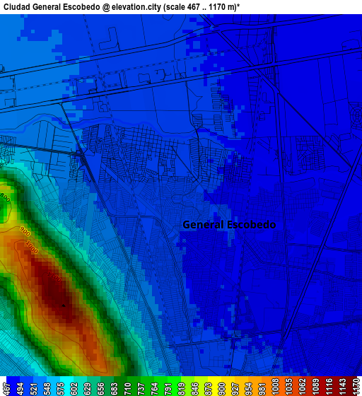
Below is the Elevation map of Ciudad General Escobedo, which displays elevation range with different colors. Scale of the first map is from 467 to 1170 m (1532 to 3839 ft) with average elevation of 548.5 meters (=1800 ft) [note 1]
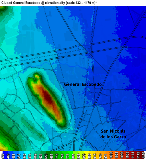
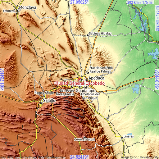
These maps also provides idea of topography and contour of this city, they are displayed at different zoom levels. More info about maps, scale and edge coordinates you can find below images.
| \ | Map #1 | Map #2 | Topo.Map |
| Scale [m] | 467..1170 m | 432..1170 m | × |
| Scale [ft] | 1532..3839 ft | 1417..3839 ft | × |
| Average | 548.5 m = 1800 ft | 528.5 m = 1734 ft | × |
| Width | 8.8 km = 5.5 mi | 17.6 km = 10.9 mi | 281.5 km = 174.9 mi |
| Height | 8.8 km = 5.5 mi | 17.6 km = 10.9 mi | 281.6 km = 175 mi |
| ↑Max Latitude | 25.836539° | 25.876085° | 27.05625° |
| Latitude at center | 25.79698° | 25.79698° | 25.79698° |
| ↓Min Latitude | 25.757408° | 25.717822° | 24.52419° |
| ← Min Longitude | -100.361855° | -100.405801° | -101.72416° |
| Longitude center | -100.31791° | -100.31791° | -100.31791° |
| →Max Longitude | -100.273965° | -100.230019° | -98.91166° |
Nearby cities:
Cities around Ciudad General Escobedo sort by population:
• San Nicolás de los Garza elevation 510 m
6.3 km,  165°
165°
• Santa Rosa 431 m
10.1 km,  72°
72°
• Prados de Santa Rosa 440 m
9.1 km,  89°
89°
• Alianza Real 545 m
8.9 km,  312°
312°
• Simeprodeso (Colectivo Nuevo) 476 m
6.8 km,  22°
22°
• Fraccionamiento Cosmópolis Octavo Sector 453 m
7.8 km, 66°
• Entronque Laredo-Salinas Victoria 451 m
9.6 km,  47°
47°
• Buena Vista 516 m
7.4 km,  325°
325°
• Monclova Primer Sector 557 m
8.7 km,  283°
283°
• Praderas de San Francisco 555 m
8.8 km,  285°
285°
• Monclova Segundo Sector 554 m
8.2 km, 284°
• Unión Agropecuarios Lázaro Cárdenas del Norte 541 m
7.7 km,  300°
300°
Multilingual:
 En español:
Ciudad General Escobedo elevación 499 m.
 En France:
Ciudad General Escobedo élévation 499 m.
 Auf Deutsch:
Ciudad General Escobedo höhe über dem Meeresspiegel ist 499 m.
 На русском:
Ciudad General Escobedo высота над уровнем моря 499 м
Sources and notes:
- [note 1] Map square and city borders are not equal. Map elevation data is calculated only from area inside that square.
- [src 1] Elevation data from geonames database provided with same terms of usage.
- [src 2] The elevation map of Ciudad General Escobedo is generated using elevation data from NASA's 3 arcsec (90m) resolution SRTM data.
- [src 3] Base (background) map © OpenStreetMap contributors tiles are generated by Geofabrik and OpenTopoMap.
Copyright & License:
This Ciudad General Escobedo Elevation Map is licensed under CC BY-SA. You may reuse any part from this page, if you give a proper credit by linking to this URL:
 More info on terms of use page.