Aticama elevation
Aticama (Nayarit, San Blas), Mexico elevation is 13 meters and Aticama elevation in feet is 43 ft above sea level [src 1]. Aticama is a populated place (feature code) with elevation that is 1301 meters (4268 ft) smaller than average city elevation in Mexico.
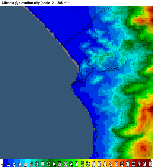
Below is the Elevation map of Aticama, which displays elevation range with different colors. Scale of the first map is from -2 to 585 m (-7 to 1919 ft) with average elevation of 126 meters (=413 ft) [note 1]
These maps also provides idea of topography and contour of this city, they are displayed at different zoom levels. More info about maps, scale and edge coordinates you can find below images.
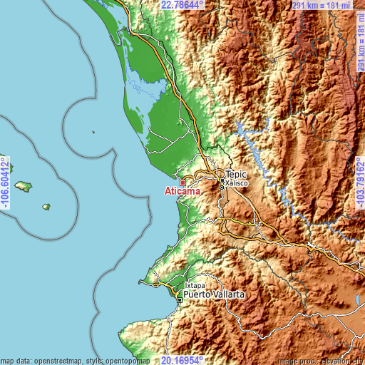
| \ | Map #1 | Topo.Map |
| Scale [m] | -2..585 m | × |
| Scale [ft] | -7..1919 ft | × |
| Average | 126 m = 413 ft | × |
| Width | 9.09 km = 5.6 mi | 291 km = 180.8 mi |
| Height | 9.09 km = 5.6 mi | 291 km = 180.8 mi |
| ↑Max Latitude | 21.524756° | 22.78644° |
| Latitude at center | 21.48387° | 21.48387° |
| ↓Min Latitude | 21.442972° | 20.16954° |
| ← Min Longitude | -105.241815° | -106.60412° |
| Longitude center | -105.19787° | -105.19787° |
| →Max Longitude | -105.153925° | -103.79162° |
Nearby cities:
Cities around Aticama sort by population:
• San Blas elevation 8 m
11.2 km,  306°
306°
• Zacualpan 29 m
26.5 km,  172°
172°
• Jalcocotán 437 m
10.3 km,  91°
91°
• Guadalupe Victoria 12 m
25.6 km,  328°
328°
• Mecatán 309 m
10 km,  54°
54°
• Aután 9 m
25.5 km, 333°
• Navarrete 72 m
20.2 km,  24°
24°
• La Libertad 220 m
12.4 km,  11°
11°
• Ixtapan de la Concepción 46 m
20 km, 168°
• El Llano 50 m
7.5 km, 165°
• El Ahuacate 995 m
26.5 km,  82°
82°
• La Palma 47 m
2.2 km,  66°
66°
Multilingual:
 En español:
Aticama elevación 13 m.
 En France:
Aticama élévation 13 m.


Sources and notes:
- [note 1] Map square and city borders are not equal. Map elevation data is calculated only from area inside that square.
- [src 1] Elevation data from geonames database provided with same terms of usage.
- [src 2] The elevation map of Aticama is generated using elevation data from NASA's 3 arcsec (90m) resolution SRTM data.
- [src 3] Base (background) map © OpenStreetMap contributors tiles are generated by Geofabrik and OpenTopoMap.
Copyright & License:
This Aticama Elevation Map is licensed under CC BY-SA. You may reuse any part from this page, if you give a proper credit by linking to this URL:
 More info on terms of use page.