Jalcocotán elevation
Jalcocotán (Nayarit, San Blas), Mexico elevation is 437 meters and Jalcocotán elevation in feet is 1434 ft above sea level [src 1]. Jalcocotán is a populated place (feature code) with elevation that is 877 meters (2877 ft) smaller than average city elevation in Mexico.
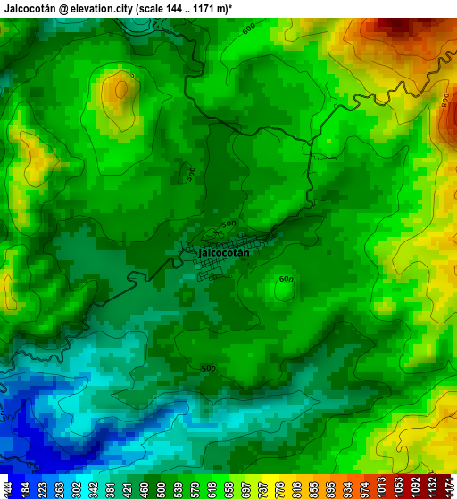
Below is the Elevation map of Jalcocotán, which displays elevation range with different colors. Scale of the first map is from 144 to 1171 m (472 to 3842 ft) with average elevation of 543.9 meters (=1784 ft) [note 1]
These maps also provides idea of topography and contour of this city, they are displayed at different zoom levels. More info about maps, scale and edge coordinates you can find below images.
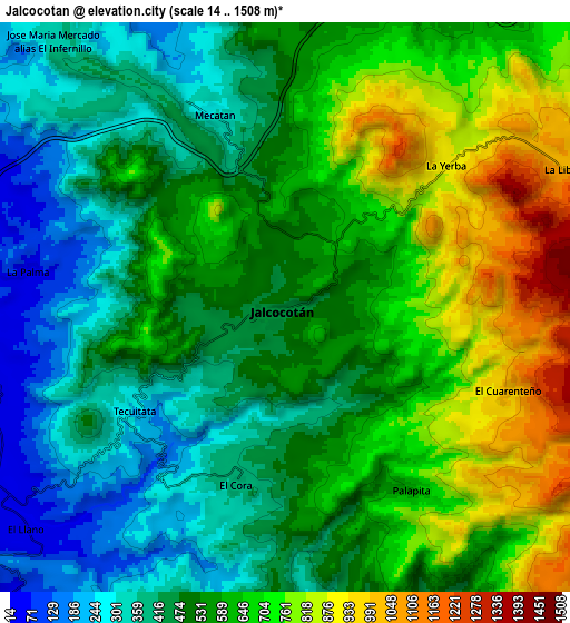
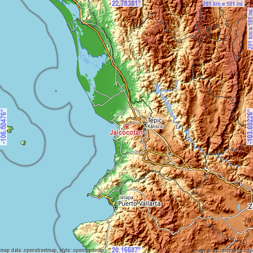
| \ | Map #1 | Map #2 | Topo.Map |
| Scale [m] | 144..1171 m | 14..1508 m | × |
| Scale [ft] | 472..3842 ft | 46..4948 ft | × |
| Average | 543.9 m = 1784 ft | 558.8 m = 1833 ft | × |
| Width | 9.09 km = 5.6 mi | 18.19 km = 11.3 mi | 291 km = 180.8 mi |
| Height | 9.09 km = 5.6 mi | 18.19 km = 11.3 mi | 291 km = 180.8 mi |
| ↑Max Latitude | 21.522107° | 21.562983° | 22.78381° |
| Latitude at center | 21.48122° | 21.48122° | 21.48122° |
| ↓Min Latitude | 21.440321° | 21.399412° | 20.16687° |
| ← Min Longitude | -105.142455° | -105.186401° | -106.50476° |
| Longitude center | -105.09851° | -105.09851° | -105.09851° |
| →Max Longitude | -105.054565° | -105.010619° | -103.69226° |
Nearby cities:
Cities around Jalcocotán sort by population:
• Xalisco elevation 997 m
21 km,  99°
99°
• San Blas 8 m
20.5 km,  289°
289°
• Mecatán 309 m
6.5 km,  340°
340°
• Navarrete 72 m
18.7 km,  354°
354°
• La Libertad 220 m
14.7 km,  328°
328°
• Ixtapan de la Concepción 46 m
20.2 km,  197°
197°
• Aticama 13 m
10.3 km,  271°
271°
• Lo de Lamedo 841 m
17.6 km,  68°
68°
• El Llano 50 m
10.9 km,  230°
230°
• El Ahuacate 995 m
16.4 km,  76°
76°
• La Palma 47 m
8.3 km,  278°
278°
• La Fortuna 808 m
17.2 km,  62°
62°
Multilingual:
 En español:
Jalcocotán elevación 437 m.
 En France:
Jalcocotán élévation 437 m.
 Auf Deutsch:
Jalcocotán höhe über dem Meeresspiegel ist 437 m.

Sources and notes:
- [note 1] Map square and city borders are not equal. Map elevation data is calculated only from area inside that square.
- [src 1] Elevation data from geonames database provided with same terms of usage.
- [src 2] The elevation map of Jalcocotán is generated using elevation data from NASA's 3 arcsec (90m) resolution SRTM data.
- [src 3] Base (background) map © OpenStreetMap contributors tiles are generated by Geofabrik and OpenTopoMap.
Copyright & License:
This Jalcocotán Elevation Map is licensed under CC BY-SA. You may reuse any part from this page, if you give a proper credit by linking to this URL:
 More info on terms of use page.