Xalisco elevation
Xalisco (Nayarit), Mexico elevation is 997 meters and Xalisco elevation in feet is 3271 ft above sea level [src 1]. Xalisco is a seat of a second-order administrative division (feature code) with elevation that is 317 meters (1040 ft) smaller than average city elevation in Mexico.
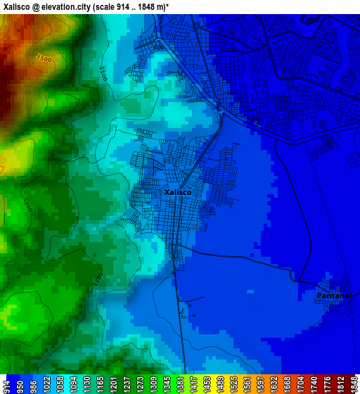
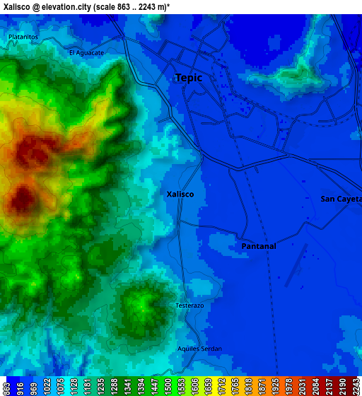
Below is the Elevation map of Xalisco, which displays elevation range with different colors. Scale of the first map is from 914 to 1848 m (2999 to 6063 ft) with average elevation of 1075.9 meters (=3530 ft) [note 1]
These maps also provides idea of topography and contour of this city, they are displayed at different zoom levels. More info about maps, scale and edge coordinates you can find below images.
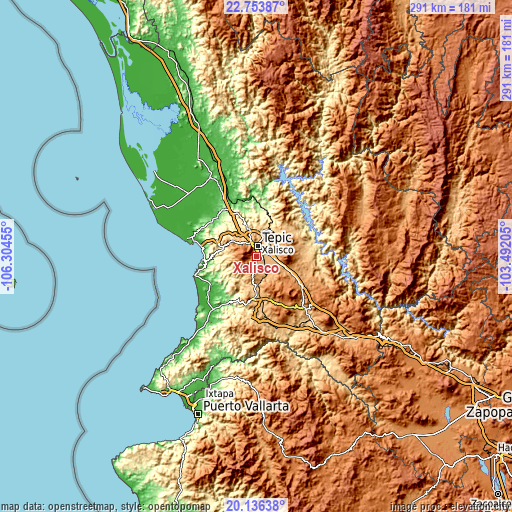
| \ | Map #1 | Map #2 | Topo.Map |
| Scale [m] | 914..1848 m | 863..2243 m | × |
| Scale [ft] | 2999..6063 ft | 2831..7359 ft | × |
| Average | 1075.9 m = 3530 ft | 1121.4 m = 3679 ft | × |
| Width | 9.1 km = 5.7 mi | 18.19 km = 11.3 mi | 291 km = 180.8 mi |
| Height | 9.1 km = 5.7 mi | 18.19 km = 11.3 mi | 291.1 km = 180.9 mi |
| ↑Max Latitude | 21.491896° | 21.53278° | 22.75387° |
| Latitude at center | 21.451° | 21.451° | 21.451° |
| ↓Min Latitude | 21.410093° | 21.369175° | 20.13638° |
| ← Min Longitude | -104.942245° | -104.986191° | -106.30455° |
| Longitude center | -104.8983° | -104.8983° | -104.8983° |
| →Max Longitude | -104.854355° | -104.810409° | -103.49205° |
Nearby cities:
Cities around Xalisco sort by population:
• Tepic elevation 932 m
6.5 km,  2°
2°
• San Cayetano 948 m
8.4 km,  91°
91°
• Pantanal 952 m
4.6 km,  123°
123°
• Testerazo 1029 m
5.4 km,  175°
175°
• Camichín de Jauja 976 m
10.2 km,  81°
81°
• Bellavista 783 m
12.5 km,  7°
7°
• Emiliano Zapata 1062 m
9.7 km,  188°
188°
• Lo de Lamedo 841 m
10.6 km,  336°
336°
• La Cantera 963 m
9.8 km,  53°
53°
• El Ahuacate 995 m
8.6 km,  326°
326°
• La Corregidora 959 m
8.9 km, 94°
• Aquiles Serdán 984 m
7.7 km,  172°
172°
Multilingual:
 En español:
Xalisco, Jalisco elevación 997 m.
 En France:
Xalisco élévation 997 m.


Sources and notes:
- [note 1] Map square and city borders are not equal. Map elevation data is calculated only from area inside that square.
- [src 1] Elevation data from geonames database provided with same terms of usage.
- [src 2] The elevation map of Xalisco is generated using elevation data from NASA's 3 arcsec (90m) resolution SRTM data.
- [src 3] Base (background) map © OpenStreetMap contributors tiles are generated by Geofabrik and OpenTopoMap.
Copyright & License:
This Xalisco Elevation Map is licensed under CC BY-SA. You may reuse any part from this page, if you give a proper credit by linking to this URL:
 More info on terms of use page.