Benjamín Hill elevation
Benjamín Hill (Sonora), Mexico elevation is 718 meters and Benjamín Hill elevation in feet is 2356 ft above sea level [src 1]. Benjamín Hill is a seat of a second-order administrative division (feature code) with elevation that is 596 meters (1955 ft) smaller than average city elevation in Mexico.
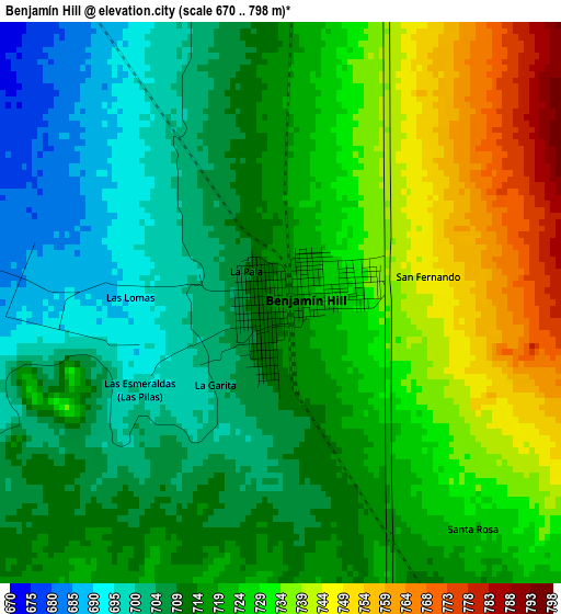
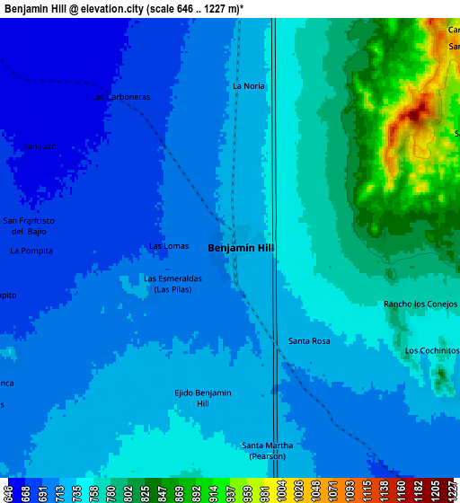
Below is the Elevation map of Benjamín Hill, which displays elevation range with different colors. Scale of the first map is from 670 to 798 m (2198 to 2618 ft) with average elevation of 720 meters (=2362 ft) [note 1]
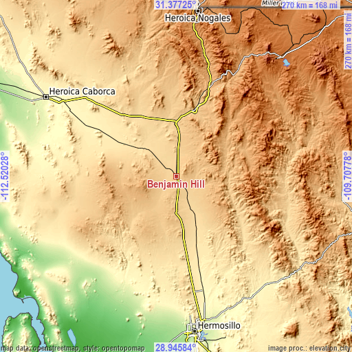
These maps also provides idea of topography and contour of this city, they are displayed at different zoom levels. More info about maps, scale and edge coordinates you can find below images.
| \ | Map #1 | Map #2 | Topo.Map |
| Scale [m] | 670..798 m | 646..1227 m | × |
| Scale [ft] | 2198..2618 ft | 2119..4026 ft | × |
| Average | 720 m = 2362 ft | 738 m = 2421 ft | × |
| Width | 8.45 km = 5.3 mi | 16.9 km = 10.5 mi | 270.3 km = 168 mi |
| Height | 8.45 km = 5.3 mi | 16.9 km = 10.5 mi | 270.4 km = 168 mi |
| ↑Max Latitude | 30.207025° | 30.244996° | 31.37725° |
| Latitude at center | 30.16904° | 30.16904° | 30.16904° |
| ↓Min Latitude | 30.13104° | 30.093025° | 28.94584° |
| ← Min Longitude | -111.157975° | -111.201921° | -112.52028° |
| Longitude center | -111.11403° | -111.11403° | -111.11403° |
| →Max Longitude | -111.070085° | -111.026139° | -109.70778° |
Nearby cities:
Cities around Benjamín Hill sort by population:
• Magdalena de Kino elevation 771 m
53.1 km,  15°
15°
• Santa Ana 694 m
41.3 km,  359°
359°
• Imuris 867 m
73.6 km, 20°
• Carbo 468 m
56.1 km,  164°
164°
• Querobabi 657 m
15.6 km,  147°
147°
• Rayón 547 m
73.2 km,  133°
133°
• Estación Llano 705 m
21.4 km,  2°
2°
• Campo Carretero 837 m
71.5 km, 20°
• Trincheras 505 m
47.4 km,  302°
302°
• San Ignacio 792 m
61.5 km, 17°
• Cucurpe 860 m
43.1 km,  65°
65°
• Opodepe 654 m
53.9 km,  120°
120°
Multilingual:
 En español:
Benjamin Hill elevación 718 m.
 En France:
Benjamín Hill élévation 718 m.
 Auf Deutsch:
Benjamín Hill höhe über dem Meeresspiegel ist 718 m.

Sources and notes:
- [note 1] Map square and city borders are not equal. Map elevation data is calculated only from area inside that square.
- [src 1] Elevation data from geonames database provided with same terms of usage.
- [src 2] The elevation map of Benjamín Hill is generated using elevation data from NASA's 3 arcsec (90m) resolution SRTM data.
- [src 3] Base (background) map © OpenStreetMap contributors tiles are generated by Geofabrik and OpenTopoMap.
Copyright & License:
This Benjamín Hill Elevation Map is licensed under CC BY-SA. You may reuse any part from this page, if you give a proper credit by linking to this URL:
 More info on terms of use page.