Imuris elevation
Imuris (Sonora), Mexico elevation is 867 meters and Imuris elevation in feet is 2844 ft above sea level [src 1]. Imuris is a populated place (feature code) with elevation that is 447 meters (1467 ft) smaller than average city elevation in Mexico.
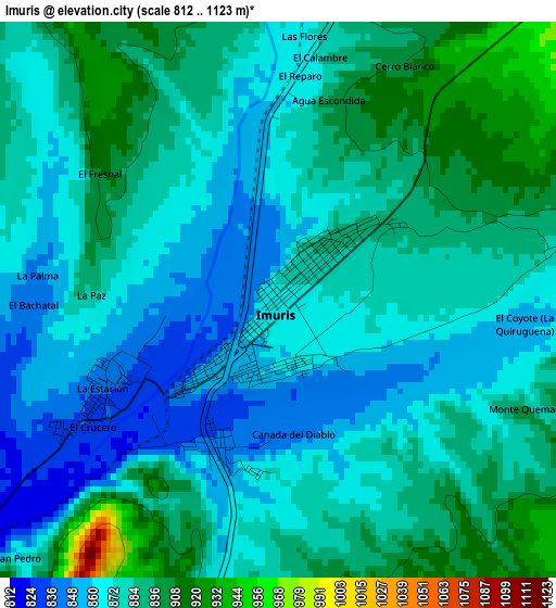
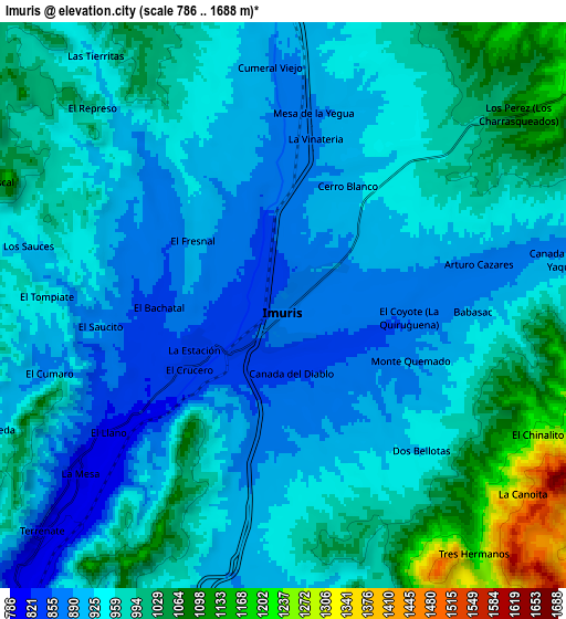
Below is the Elevation map of Imuris, which displays elevation range with different colors. Scale of the first map is from 812 to 1123 m (2664 to 3684 ft) with average elevation of 877.4 meters (=2879 ft) [note 1]
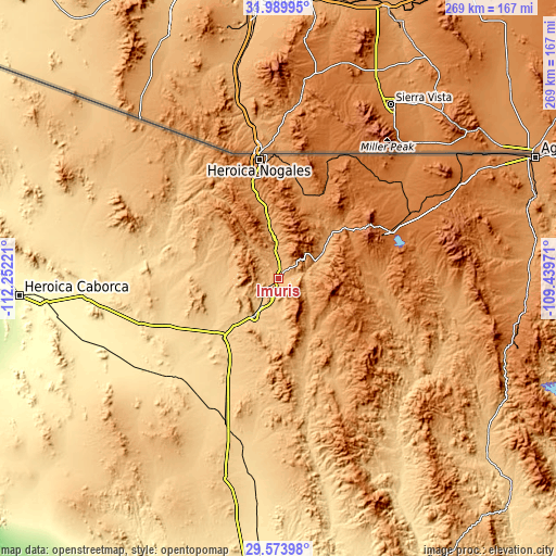
These maps also provides idea of topography and contour of this city, they are displayed at different zoom levels. More info about maps, scale and edge coordinates you can find below images.
| \ | Map #1 | Map #2 | Topo.Map |
| Scale [m] | 812..1123 m | 786..1688 m | × |
| Scale [ft] | 2664..3684 ft | 2579..5538 ft | × |
| Average | 877.4 m = 2879 ft | 956.4 m = 3138 ft | × |
| Width | 8.4 km = 5.2 mi | 16.79 km = 10.4 mi | 268.6 km = 166.9 mi |
| Height | 8.4 km = 5.2 mi | 16.79 km = 10.4 mi | 268.6 km = 166.9 mi |
| ↑Max Latitude | 30.827294° | 30.865023° | 31.98995° |
| Latitude at center | 30.78955° | 30.78955° | 30.78955° |
| ↓Min Latitude | 30.751791° | 30.714018° | 29.57398° |
| ← Min Longitude | -110.889905° | -110.933851° | -112.25221° |
| Longitude center | -110.84596° | -110.84596° | -110.84596° |
| →Max Longitude | -110.802015° | -110.758069° | -109.43971° |
Nearby cities:
Cities around Imuris sort by population:
• Nogales elevation 1214 m
58.4 km,  350°
350°
• Cananea 1599 m
57.4 km,  67°
67°
• Magdalena de Kino 771 m
21.1 km,  211°
211°
• Santa Ana 694 m
38 km,  223°
223°
• La Mesa 1182 m
42.9 km,  343°
343°
• Centro de Readaptación Social Nuevo 1195 m
45.4 km, 345°
• Estación Llano 705 m
53.6 km, 207°
• Campo Carretero 837 m
2.1 km,  200°
200°
• San Ignacio 792 m
12.6 km, 215°
• Santa Cruz 1361 m
54.8 km,  25°
25°
• Cucurpe 860 m
52.8 km,  165°
165°
• Tubutama 650 m
60.1 km,  280°
280°
Multilingual:
 En español:
Imuris elevación 867 m.
 En France:
Imuris élévation 867 m.


Sources and notes:
- [note 1] Map square and city borders are not equal. Map elevation data is calculated only from area inside that square.
- [src 1] Elevation data from geonames database provided with same terms of usage.
- [src 2] The elevation map of Imuris is generated using elevation data from NASA's 3 arcsec (90m) resolution SRTM data.
- [src 3] Base (background) map © OpenStreetMap contributors tiles are generated by Geofabrik and OpenTopoMap.
Copyright & License:
This Imuris Elevation Map is licensed under CC BY-SA. You may reuse any part from this page, if you give a proper credit by linking to this URL:
 More info on terms of use page.