Nogales elevation
Nogales (Sonora), Mexico elevation is 1214 meters and Nogales elevation in feet is 3983 ft above sea level [src 1]. Nogales is a populated place (feature code) with elevation that is 100 meters (328 ft) smaller than average city elevation in Mexico.
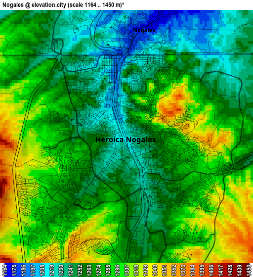
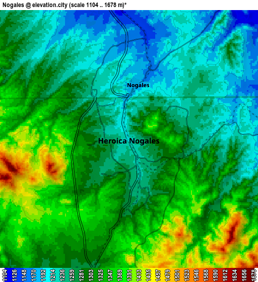
Below is the Elevation map of Nogales, which displays elevation range with different colors. Scale of the first map is from 1164 to 1450 m (3819 to 4757 ft) with average elevation of 1272.9 meters (=4176 ft) [note 1]
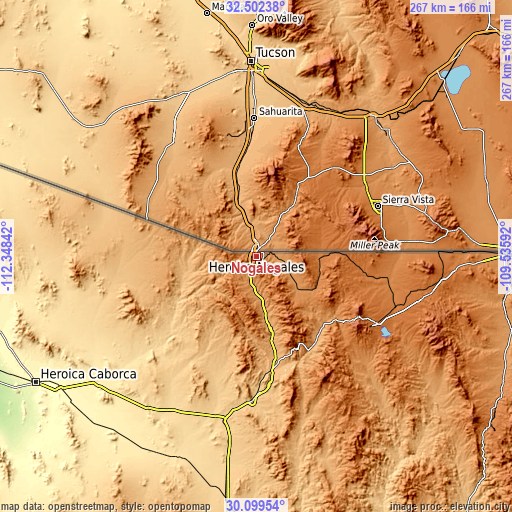
These maps also provides idea of topography and contour of this city, they are displayed at different zoom levels. More info about maps, scale and edge coordinates you can find below images.
| \ | Map #1 | Map #2 | Topo.Map |
| Scale [m] | 1164..1450 m | 1104..1678 m | × |
| Scale [ft] | 3819..4757 ft | 3622..5505 ft | × |
| Average | 1272.9 m = 4176 ft | 1291.4 m = 4237 ft | × |
| Width | 8.35 km = 5.2 mi | 16.7 km = 10.4 mi | 267.2 km = 166 mi |
| Height | 8.35 km = 5.2 mi | 16.7 km = 10.4 mi | 267.2 km = 166 mi |
| ↑Max Latitude | 31.346159° | 31.383682° | 32.50238° |
| Latitude at center | 31.30862° | 31.30862° | 31.30862° |
| ↓Min Latitude | 31.271066° | 31.233498° | 30.09954° |
| ← Min Longitude | -110.986115° | -111.030061° | -112.34842° |
| Longitude center | -110.94217° | -110.94217° | -110.94217° |
| →Max Longitude | -110.898225° | -110.854279° | -109.53592° |
Nearby cities:
Cities around Nogales sort by population:
• Cananea elevation 1599 m
71.6 km,  119°
119°
• Magdalena de Kino 771 m
75.7 km,  181°
181°
• Imuris 867 m
58.4 km,  170°
170°
• La Mesa 1182 m
16.8 km,  190°
190°
• Centro de Readaptación Social Nuevo 1195 m
14 km, 189°
• Aduana del Sásabe 1075 m
60.1 km,  287°
287°
• Campo Carretero 837 m
60.3 km, 171°
• San Ignacio 792 m
68 km, 178°
• Santa Cruz 1361 m
33.9 km,  104°
104°
• Sáric 780 m
47.4 km,  241°
241°
• Atil 568 m
80 km,  229°
229°
• Tubutama 650 m
68.6 km, 226°
Multilingual:
 En español:
Nogales, Los Nogales, Heroica Nogales elevación 1214 m.
 En France:
Nogales élévation 1214 m.
 Auf Deutsch:
Nogales höhe über dem Meeresspiegel ist 1214 m.

Sources and notes:
- [note 1] Map square and city borders are not equal. Map elevation data is calculated only from area inside that square.
- [src 1] Elevation data from geonames database provided with same terms of usage.
- [src 2] The elevation map of Nogales is generated using elevation data from NASA's 3 arcsec (90m) resolution SRTM data.
- [src 3] Base (background) map © OpenStreetMap contributors tiles are generated by Geofabrik and OpenTopoMap.
Copyright & License:
This Nogales Elevation Map is licensed under CC BY-SA. You may reuse any part from this page, if you give a proper credit by linking to this URL:
 More info on terms of use page.