Rayón elevation
Rayón (Sonora), Mexico elevation is 547 meters and Rayón elevation in feet is 1795 ft above sea level [src 1]. Rayón is a seat of a second-order administrative division (feature code) with elevation that is 767 meters (2516 ft) smaller than average city elevation in Mexico.
Below is the Elevation map of Rayón, which displays elevation range with different colors. Scale of the first map is from 515 to 935 m (1690 to 3068 ft) with average elevation of 595.5 meters (=1954 ft) [note 1]
These maps also provides idea of topography and contour of this city, they are displayed at different zoom levels. More info about maps, scale and edge coordinates you can find below images.
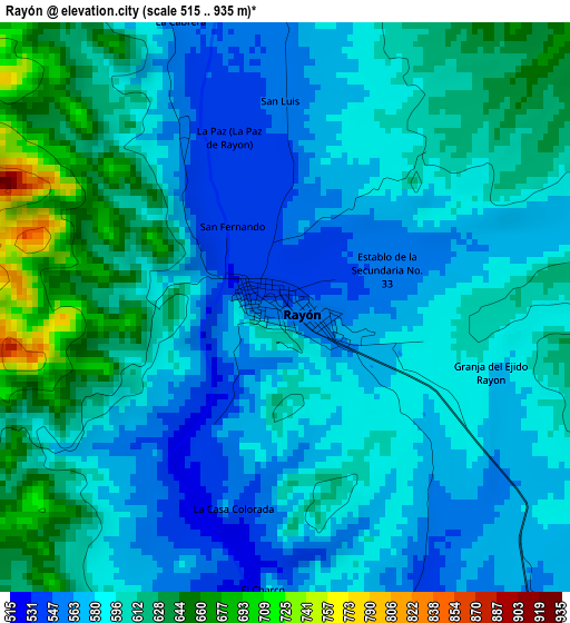
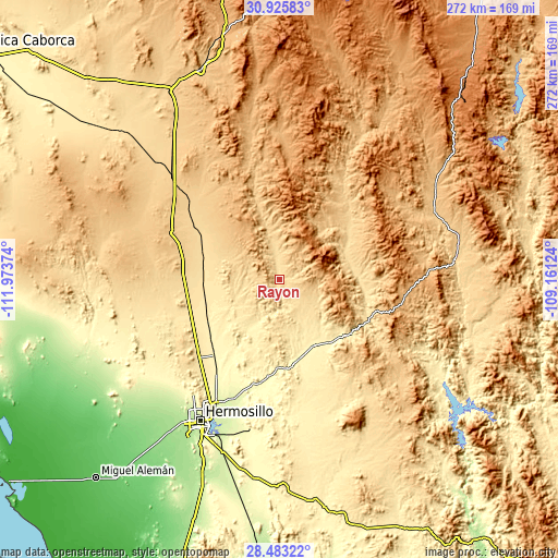
| \ | Map #1 | Topo.Map |
| Scale [m] | 515..935 m | × |
| Scale [ft] | 1690..3068 ft | × |
| Average | 595.5 m = 1954 ft | × |
| Width | 8.49 km = 5.3 mi | 271.6 km = 168.8 mi |
| Height | 8.49 km = 5.3 mi | 271.6 km = 168.8 mi |
| ↑Max Latitude | 29.75011° | 30.92583° |
| Latitude at center | 29.71195° | 29.71195° |
| ↓Min Latitude | 29.673775° | 28.48322° |
| ← Min Longitude | -110.611435° | -111.97374° |
| Longitude center | -110.56749° | -110.56749° |
| →Max Longitude | -110.523545° | -109.16124° |
Nearby cities:
Cities around Rayón sort by population:
• Pesqueira elevation 326 m
48.7 km,  220°
220°
• Carbo 468 m
37.7 km,  265°
265°
• Ures 387 m
36.1 km,  151°
151°
• Querobabi 657 m
58.1 km,  310°
310°
• Baviácora 560 m
39.1 km,  89°
89°
• Aconchi 617 m
35.4 km,  68°
68°
• Banámichi 678 m
47.2 km,  45°
45°
• Las Mercedes [Agropecuaria] 407 m
53.7 km, 223°
• Huépac 645 m
40.7 km,  57°
57°
• San Miguel de Horcasitas 394 m
29.2 km,  211°
211°
• San Felipe de Jesús 623 m
35.9 km, 62°
• Opodepe 654 m
24.5 km,  345°
345°
Multilingual:
 En español:
Rayón elevación 547 m.
 En France:
Rayón élévation 547 m.


Sources and notes:
- [note 1] Map square and city borders are not equal. Map elevation data is calculated only from area inside that square.
- [src 1] Elevation data from geonames database provided with same terms of usage.
- [src 2] The elevation map of Rayón is generated using elevation data from NASA's 3 arcsec (90m) resolution SRTM data.
- [src 3] Base (background) map © OpenStreetMap contributors tiles are generated by Geofabrik and OpenTopoMap.
Copyright & License:
This Rayón Elevation Map is licensed under CC BY-SA. You may reuse any part from this page, if you give a proper credit by linking to this URL:
 More info on terms of use page.