Pesqueira elevation
Pesqueira (Sonora, San Miguel de Horcasitas), Mexico elevation is 326 meters and Pesqueira elevation in feet is 1070 ft above sea level [src 1]. Pesqueira is a populated place (feature code) with elevation that is 988 meters (3241 ft) smaller than average city elevation in Mexico.
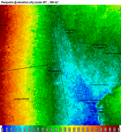
Below is the Elevation map of Pesqueira, which displays elevation range with different colors. Scale of the first map is from 307 to 396 m (1007 to 1299 ft) with average elevation of 344.9 meters (=1132 ft) [note 1]
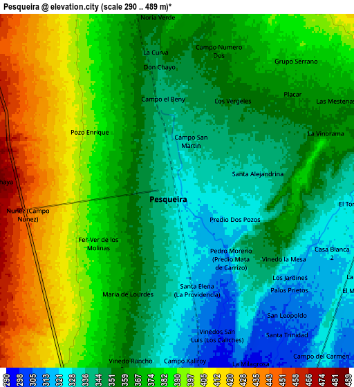
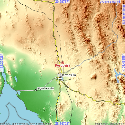
These maps also provides idea of topography and contour of this city, they are displayed at different zoom levels. More info about maps, scale and edge coordinates you can find below images.
| \ | Map #1 | Map #2 | Topo.Map |
| Scale [m] | 307..396 m | 290..489 m | × |
| Scale [ft] | 1007..1299 ft | 951..1604 ft | × |
| Average | 344.9 m = 1132 ft | 365.8 m = 1200 ft | × |
| Width | 8.52 km = 5.3 mi | 17.03 km = 10.6 mi | 272.5 km = 169.3 mi |
| Height | 8.52 km = 5.3 mi | 17.03 km = 10.6 mi | 272.5 km = 169.3 mi |
| ↑Max Latitude | 29.418006° | 29.456278° | 30.59767° |
| Latitude at center | 29.37972° | 29.37972° | 29.37972° |
| ↓Min Latitude | 29.341419° | 29.303104° | 28.14702° |
| ← Min Longitude | -110.940055° | -110.984001° | -112.30236° |
| Longitude center | -110.89611° | -110.89611° | -110.89611° |
| →Max Longitude | -110.852165° | -110.808219° | -109.48986° |
Nearby cities:
Cities around Pesqueira sort by population:
• Hermosillo elevation 212 m
31.8 km,  194°
194°
• Carbo 468 m
34.2 km,  350°
350°
• Ures 387 m
49.5 km,  83°
83°
• Querobabi 657 m
75.7 km, 350°
• La Victoria 239 m
28.6 km,  178°
178°
• Rayón 547 m
48.7 km,  40°
40°
• Las Mercedes [Agropecuaria] 407 m
5.7 km,  251°
251°
• Molino de Camou 267 m
23.7 km,  145°
145°
• Estación Zamora 280 m
13.2 km, 175°
• San Miguel de Horcasitas 394 m
20.5 km,  54°
54°
• Opodepe 654 m
66 km,  23°
23°
• La Colorada 387 m
71.1 km, 154°
Multilingual:
 En español:
Pesqueira elevación 326 m.
 En France:
Pesqueira élévation 326 m.
 Auf Deutsch:
Pesqueira höhe über dem Meeresspiegel ist 326 m.

Sources and notes:
- [note 1] Map square and city borders are not equal. Map elevation data is calculated only from area inside that square.
- [src 1] Elevation data from geonames database provided with same terms of usage.
- [src 2] The elevation map of Pesqueira is generated using elevation data from NASA's 3 arcsec (90m) resolution SRTM data.
- [src 3] Base (background) map © OpenStreetMap contributors tiles are generated by Geofabrik and OpenTopoMap.
Copyright & License:
This Pesqueira Elevation Map is licensed under CC BY-SA. You may reuse any part from this page, if you give a proper credit by linking to this URL:
 More info on terms of use page.