Estación Camacho elevation
Estación Camacho (Zacatecas, Mazapil), Mexico elevation is 1663 meters and Estación Camacho elevation in feet is 5456 ft above sea level [src 1]. Estación Camacho is a populated place (feature code) with elevation that is 349 meters (1145 ft) bigger than average city elevation in Mexico.
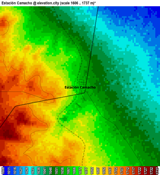
Below is the Elevation map of Estación Camacho, which displays elevation range with different colors. Scale of the first map is from 1606 to 1737 m (5269 to 5699 ft) with average elevation of 1665.5 meters (=5464 ft) [note 1]
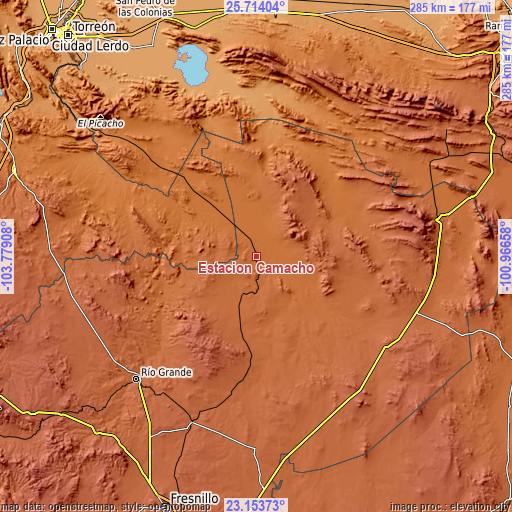
These maps also provides idea of topography and contour of this city, they are displayed at different zoom levels. More info about maps, scale and edge coordinates you can find below images.
| \ | Map #1 | Topo.Map |
| Scale [m] | 1606..1737 m | × |
| Scale [ft] | 5269..5699 ft | × |
| Average | 1665.5 m = 5464 ft | × |
| Width | 8.9 km = 5.5 mi | 284.7 km = 176.9 mi |
| Height | 8.9 km = 5.5 mi | 284.7 km = 176.9 mi |
| ↑Max Latitude | 24.480381° | 25.71404° |
| Latitude at center | 24.44038° | 24.44038° |
| ↓Min Latitude | 24.400366° | 23.15373° |
| ← Min Longitude | -102.416775° | -103.77908° |
| Longitude center | -102.37283° | -102.37283° |
| →Max Longitude | -102.328885° | -100.96658° |
Nearby cities:
Cities around Estación Camacho sort by population:
• Río Grande elevation 1870 m
95.5 km,  224°
224°
• Nieves 1914 m
82.2 km,  233°
233°
• Loreto 1863 m
92.2 km, 224°
• Los Ramírez 1868 m
94.3 km, 225°
• Tetillas 2025 m
97.3 km,  213°
213°
• San Juan de Guadalupe 1529 m
46.6 km,  297°
297°
• General Simón Bolívar 1537 m
90.6 km,  287°
287°
• Terminal de Providencia 1955 m
95.9 km,  73°
73°
• Santa Rita 1823 m
78 km, 224°
• La Laguna 2043 m
85.9 km,  252°
252°
• Cedros 1768 m
66.1 km, 66°
• Mazapil 2274 m
85.7 km,  75°
75°
Multilingual:
 En español:
Estación Camacho elevación 1663 m.
 En France:
Estación Camacho élévation 1663 m.
 Auf Deutsch:
Estación Camacho höhe über dem Meeresspiegel ist 1663 m.

Sources and notes:
- [note 1] Map square and city borders are not equal. Map elevation data is calculated only from area inside that square.
- [src 1] Elevation data from geonames database provided with same terms of usage.
- [src 2] The elevation map of Estación Camacho is generated using elevation data from NASA's 3 arcsec (90m) resolution SRTM data.
- [src 3] Base (background) map © OpenStreetMap contributors tiles are generated by Geofabrik and OpenTopoMap.
Copyright & License:
This Estación Camacho Elevation Map is licensed under CC BY-SA. You may reuse any part from this page, if you give a proper credit by linking to this URL:
 More info on terms of use page.