General Simón Bolívar elevation
General Simón Bolívar (Durango), Mexico elevation is 1537 meters and General Simón Bolívar elevation in feet is 5043 ft above sea level [src 1]. General Simón Bolívar is a seat of a second-order administrative division (feature code) with elevation that is 223 meters (732 ft) bigger than average city elevation in Mexico.
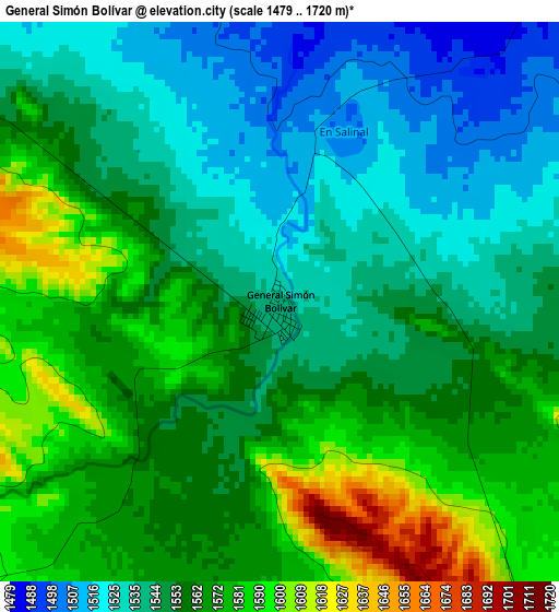
Below is the Elevation map of General Simón Bolívar, which displays elevation range with different colors. Scale of the first map is from 1479 to 1720 m (4852 to 5643 ft) with average elevation of 1555.7 meters (=5104 ft) [note 1]
These maps also provides idea of topography and contour of this city, they are displayed at different zoom levels. More info about maps, scale and edge coordinates you can find below images.
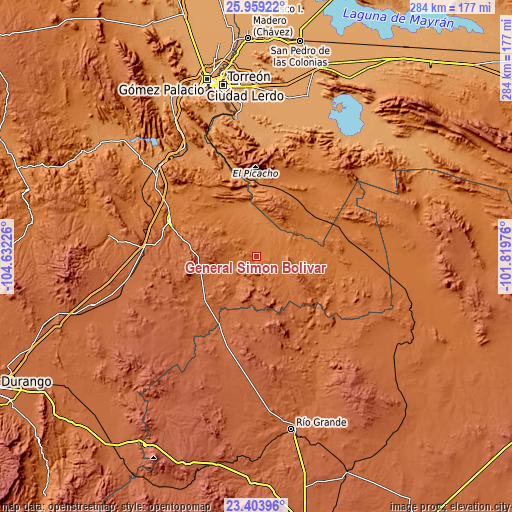
| \ | Map #1 | Topo.Map |
| Scale [m] | 1479..1720 m | × |
| Scale [ft] | 4852..5643 ft | × |
| Average | 1555.7 m = 5104 ft | × |
| Width | 8.88 km = 5.5 mi | 284.1 km = 176.5 mi |
| Height | 8.88 km = 5.5 mi | 284.1 km = 176.5 mi |
| ↑Max Latitude | 24.728062° | 25.95922° |
| Latitude at center | 24.68814° | 24.68814° |
| ↓Min Latitude | 24.648205° | 23.40396° |
| ← Min Longitude | -103.269955° | -104.63226° |
| Longitude center | -103.22601° | -103.22601° |
| →Max Longitude | -103.182065° | -101.81976° |
Nearby cities:
Cities around General Simón Bolívar sort by population:
• Juan Aldama elevation 2000 m
47.2 km,  200°
200°
• Miguel Auza 1965 m
49.4 km,  207°
207°
• Cuencamé de Ceniceros 1587 m
51.7 km,  293°
293°
• Santa Clara 1810 m
27.1 km, 209°
• Velardeña 1375 m
66.4 km,  309°
309°
• San Juan de Guadalupe 1529 m
45.3 km,  97°
97°
• Ojitos 1992 m
43.8 km, 196°
• Pasaje 1586 m
64.4 km, 294°
• San José de Zaragoza 1227 m
64.7 km,  337°
337°
• General Juan José Ríos 1947 m
44.2 km, 204°
• La Laguna 2043 m
53 km,  175°
175°
• Ignacio Zaragoza 1256 m
52.3 km, 342°
Multilingual:
 En español:
General Simón Bolívar elevación 1537 m.
 En France:
General Simón Bolívar élévation 1537 m.
 Auf Deutsch:
General Simón Bolívar höhe über dem Meeresspiegel ist 1537 m.
 На русском:
General Simón Bolívar высота над уровнем моря 1537 м
Sources and notes:
- [note 1] Map square and city borders are not equal. Map elevation data is calculated only from area inside that square.
- [src 1] Elevation data from geonames database provided with same terms of usage.
- [src 2] The elevation map of General Simón Bolívar is generated using elevation data from NASA's 3 arcsec (90m) resolution SRTM data.
- [src 3] Base (background) map © OpenStreetMap contributors tiles are generated by Geofabrik and OpenTopoMap.
Copyright & License:
This General Simón Bolívar Elevation Map is licensed under CC BY-SA. You may reuse any part from this page, if you give a proper credit by linking to this URL:
 More info on terms of use page.