Santa Clara elevation
Santa Clara (Durango), Mexico elevation is 1810 meters and Santa Clara elevation in feet is 5938 ft above sea level [src 1]. Santa Clara is a populated place (feature code) with elevation that is 496 meters (1627 ft) bigger than average city elevation in Mexico.
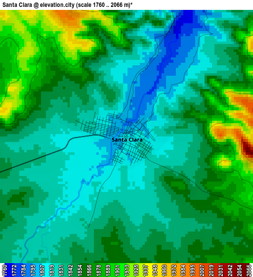
Below is the Elevation map of Santa Clara, which displays elevation range with different colors. Scale of the first map is from 1760 to 2066 m (5774 to 6778 ft) with average elevation of 1848.4 meters (=6064 ft) [note 1]
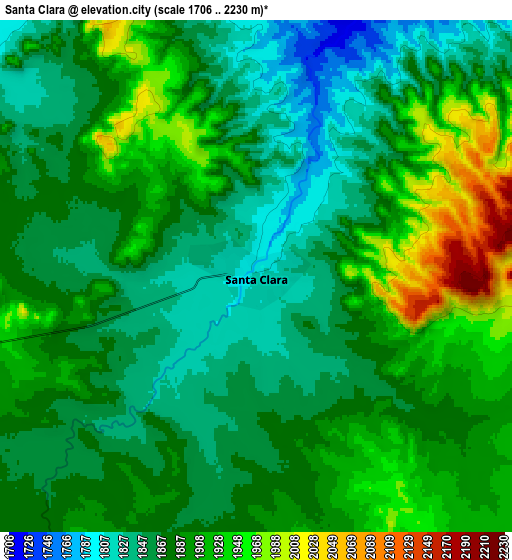
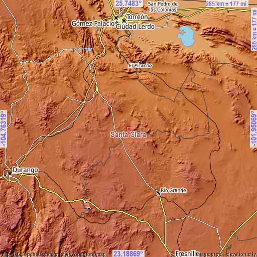
These maps also provides idea of topography and contour of this city, they are displayed at different zoom levels. More info about maps, scale and edge coordinates you can find below images.
| \ | Map #1 | Map #2 | Topo.Map |
| Scale [m] | 1760..2066 m | 1706..2230 m | × |
| Scale [ft] | 5774..6778 ft | 5597..7316 ft | × |
| Average | 1848.4 m = 6064 ft | 1886 m = 6188 ft | × |
| Width | 8.89 km = 5.5 mi | 17.79 km = 11.1 mi | 284.6 km = 176.8 mi |
| Height | 8.89 km = 5.5 mi | 17.79 km = 11.1 mi | 284.6 km = 176.8 mi |
| ↑Max Latitude | 24.51499° | 24.554968° | 25.7483° |
| Latitude at center | 24.475° | 24.475° | 24.475° |
| ↓Min Latitude | 24.434997° | 24.394982° | 23.18869° |
| ← Min Longitude | -103.400885° | -103.444831° | -104.76319° |
| Longitude center | -103.35694° | -103.35694° | -103.35694° |
| →Max Longitude | -103.312995° | -103.269049° | -101.95069° |
Nearby cities:
Cities around Santa Clara sort by population:
• Juan Aldama elevation 2000 m
20.7 km,  190°
190°
• Miguel Auza 1965 m
22.2 km,  205°
205°
• Cuencamé de Ceniceros 1587 m
55.9 km,  322°
322°
• Cuauhtemoc 2172 m
50.2 km,  245°
245°
• Emiliano Zapata 2029 m
53.9 km,  266°
266°
• Ramón Corona 2130 m
42.4 km,  220°
220°
• Emilio Carranza 2234 m
51.9 km, 217°
• Ojitos 1992 m
18.4 km,  176°
176°
• Ignacio Zaragoza 2148 m
59.4 km, 185°
• General Simón Bolívar 1537 m
27.1 km,  29°
29°
• General Juan José Ríos 1947 m
17.3 km,  196°
196°
• La Laguna 2043 m
34 km,  148°
148°
Multilingual:
 En español:
Santa Clara elevación 1810 m.
 En France:
Santa Clara élévation 1810 m.
 Auf Deutsch:
Santa Clara höhe über dem Meeresspiegel ist 1810 m.

Sources and notes:
- [note 1] Map square and city borders are not equal. Map elevation data is calculated only from area inside that square.
- [src 1] Elevation data from geonames database provided with same terms of usage.
- [src 2] The elevation map of Santa Clara is generated using elevation data from NASA's 3 arcsec (90m) resolution SRTM data.
- [src 3] Base (background) map © OpenStreetMap contributors tiles are generated by Geofabrik and OpenTopoMap.
Copyright & License:
This Santa Clara Elevation Map is licensed under CC BY-SA. You may reuse any part from this page, if you give a proper credit by linking to this URL:
 More info on terms of use page.