Nieves elevation
Nieves (Zacatecas, General Francisco R. Murguía), Mexico elevation is 1914 meters and Nieves elevation in feet is 6280 ft above sea level [src 1]. Nieves is a seat of a second-order administrative division (feature code) with elevation that is 600 meters (1969 ft) bigger than average city elevation in Mexico.
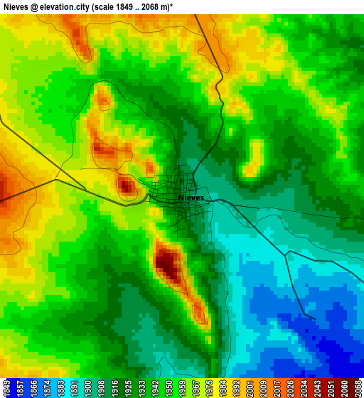
Below is the Elevation map of Nieves, which displays elevation range with different colors. Scale of the first map is from 1849 to 2068 m (6066 to 6785 ft) with average elevation of 1941.2 meters (=6369 ft) [note 1]
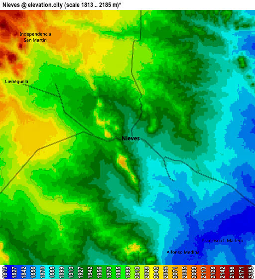
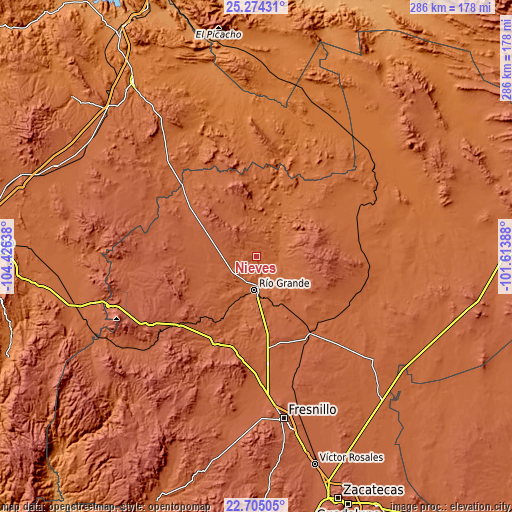
These maps also provides idea of topography and contour of this city, they are displayed at different zoom levels. More info about maps, scale and edge coordinates you can find below images.
| \ | Map #1 | Map #2 | Topo.Map |
| Scale [m] | 1849..2068 m | 1813..2185 m | × |
| Scale [ft] | 6066..6785 ft | 5948..7169 ft | × |
| Average | 1941.2 m = 6369 ft | 1948.5 m = 6393 ft | × |
| Width | 8.93 km = 5.5 mi | 17.86 km = 11.1 mi | 285.7 km = 177.5 mi |
| Height | 8.93 km = 5.5 mi | 17.86 km = 11.1 mi | 285.7 km = 177.5 mi |
| ↑Max Latitude | 24.036231° | 24.076359° | 25.27431° |
| Latitude at center | 23.99609° | 23.99609° | 23.99609° |
| ↓Min Latitude | 23.955936° | 23.91577° | 22.70505° |
| ← Min Longitude | -103.064075° | -103.108021° | -104.42638° |
| Longitude center | -103.02013° | -103.02013° | -103.02013° |
| →Max Longitude | -102.976185° | -102.932239° | -101.61388° |
Nearby cities:
Cities around Nieves sort by population:
• Río Grande elevation 1870 m
18.9 km,  183°
183°
• Loreto 1863 m
16.2 km, 176°
• Las Esperanzas (El Ranchito) 1942 m
19.8 km,  214°
214°
• Los Ramírez 1868 m
16.9 km, 184°
• Colonia Francisco García Salinas 1957 m
26.4 km,  218°
218°
• José María Morelos y Pavón 1955 m
19.3 km, 219°
• El Fuerte 1939 m
18.9 km, 213°
• Los Condes 1893 m
18.5 km,  198°
198°
• Tierra Blanca 1874 m
19.6 km, 197°
• Pastelera 1914 m
29.1 km, 195°
• La Florida 1884 m
22 km, 195°
• Santa Rita 1823 m
12 km,  118°
118°
Multilingual:
 En español:
Nieves, Francisco R. Murguia, Las Nieves elevación 1914 m.
 En France:
Nieves élévation 1914 m.


Sources and notes:
- [note 1] Map square and city borders are not equal. Map elevation data is calculated only from area inside that square.
- [src 1] Elevation data from geonames database provided with same terms of usage.
- [src 2] The elevation map of Nieves is generated using elevation data from NASA's 3 arcsec (90m) resolution SRTM data.
- [src 3] Base (background) map © OpenStreetMap contributors tiles are generated by Geofabrik and OpenTopoMap.
Copyright & License:
This Nieves Elevation Map is licensed under CC BY-SA. You may reuse any part from this page, if you give a proper credit by linking to this URL:
 More info on terms of use page.