Cedral elevation
Cedral (San Luis Potosí), Mexico elevation is 1705 meters and Cedral elevation in feet is 5594 ft above sea level [src 1]. Cedral is a seat of a second-order administrative division (feature code) with elevation that is 391 meters (1283 ft) bigger than average city elevation in Mexico.
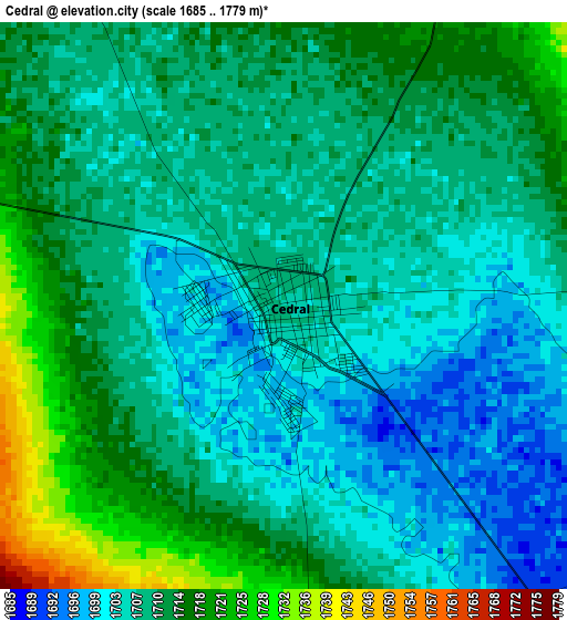
Below is the Elevation map of Cedral, which displays elevation range with different colors. Scale of the first map is from 1685 to 1779 m (5528 to 5837 ft) with average elevation of 1709.3 meters (=5608 ft) [note 1]
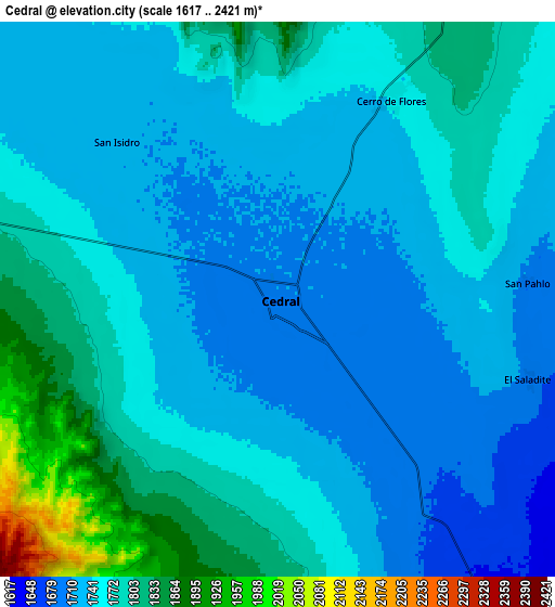
These maps also provides idea of topography and contour of this city, they are displayed at different zoom levels. More info about maps, scale and edge coordinates you can find below images.
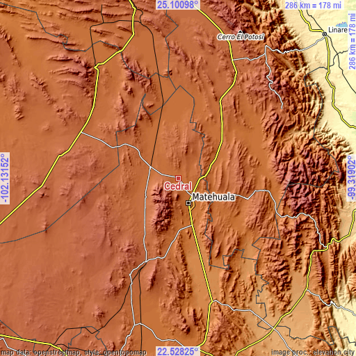
| \ | Map #1 | Map #2 | Topo.Map |
| Scale [m] | 1685..1779 m | 1617..2421 m | × |
| Scale [ft] | 5528..5837 ft | 5305..7943 ft | × |
| Average | 1709.3 m = 5608 ft | 1759.5 m = 5773 ft | × |
| Width | 8.94 km = 5.6 mi | 17.88 km = 11.1 mi | 286.1 km = 177.8 mi |
| Height | 8.94 km = 5.6 mi | 17.88 km = 11.1 mi | 286.1 km = 177.8 mi |
| ↑Max Latitude | 23.861185° | 23.901368° | 25.10098° |
| Latitude at center | 23.82099° | 23.82099° | 23.82099° |
| ↓Min Latitude | 23.780782° | 23.740562° | 22.52825° |
| ← Min Longitude | -100.769215° | -100.813161° | -102.13152° |
| Longitude center | -100.72527° | -100.72527° | -100.72527° |
| →Max Longitude | -100.681325° | -100.637379° | -99.31902° |
Nearby cities:
Cities around Cedral sort by population:
• Matehuala elevation 1581 m
20.9 km,  156°
156°
• Charcas 2017 m
86.5 km,  207°
207°
• Doctor Arroyo 1716 m
57.8 km,  106°
106°
• Villa de la Paz 1831 m
16.2 km,  175°
175°
• Vanegas 1739 m
24.1 km,  287°
287°
• San José de Raíces 1872 m
96.9 km,  30°
30°
• Real de Catorce 2678 m
22 km,  228°
228°
• Mier y Noriega 1678 m
76.2 km,  125°
125°
• San Isidro 1715 m
7.1 km,  314°
314°
• Norias del Refugio 1321 m
93.4 km, 163°
• El Salvador 1718 m
79.1 km,  349°
349°
• Villa de Guadalupe 1630 m
49.8 km, 183°
Multilingual:
 En español:
Cedral elevación 1705 m.
 En France:
Cedral élévation 1705 m.


Sources and notes:
- [note 1] Map square and city borders are not equal. Map elevation data is calculated only from area inside that square.
- [src 1] Elevation data from geonames database provided with same terms of usage.
- [src 2] The elevation map of Cedral is generated using elevation data from NASA's 3 arcsec (90m) resolution SRTM data.
- [src 3] Base (background) map © OpenStreetMap contributors tiles are generated by Geofabrik and OpenTopoMap.
Copyright & License:
This Cedral Elevation Map is licensed under CC BY-SA. You may reuse any part from this page, if you give a proper credit by linking to this URL:
 More info on terms of use page.