Chapalilla elevation
Chapalilla (Nayarit, Santa María del Oro), Mexico elevation is 891 meters and Chapalilla elevation in feet is 2923 ft above sea level [src 1]. Chapalilla is a populated place (feature code) with elevation that is 423 meters (1388 ft) smaller than average city elevation in Mexico.
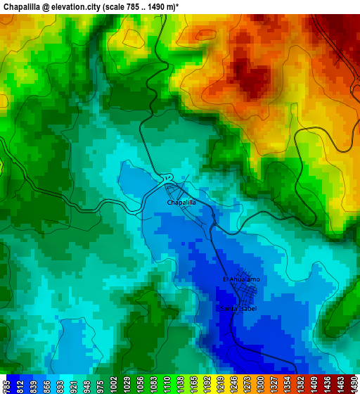
Below is the Elevation map of Chapalilla, which displays elevation range with different colors. Scale of the first map is from 785 to 1490 m (2575 to 4888 ft) with average elevation of 1033.5 meters (=3391 ft) [note 1]
These maps also provides idea of topography and contour of this city, they are displayed at different zoom levels. More info about maps, scale and edge coordinates you can find below images.
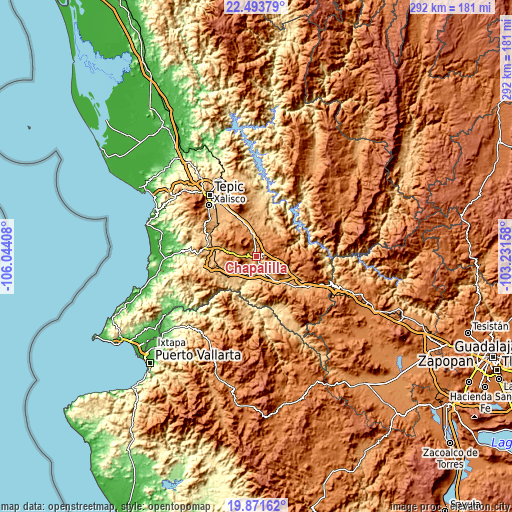
| \ | Map #1 | Topo.Map |
| Scale [m] | 785..1490 m | × |
| Scale [ft] | 2575..4888 ft | × |
| Average | 1033.5 m = 3391 ft | × |
| Width | 9.11 km = 5.7 mi | 291.6 km = 181.2 mi |
| Height | 9.11 km = 5.7 mi | 291.6 km = 181.2 mi |
| ↑Max Latitude | 21.229489° | 22.49379° |
| Latitude at center | 21.18852° | 21.18852° |
| ↓Min Latitude | 21.14754° | 19.87162° |
| ← Min Longitude | -104.681775° | -106.04408° |
| Longitude center | -104.63783° | -104.63783° |
| →Max Longitude | -104.593885° | -103.23158° |
Nearby cities:
Cities around Chapalilla sort by population:
• Ahuacatlán elevation 999 m
21.9 km,  133°
133°
• Jala 1070 m
22.7 km,  114°
114°
• Santa María del Oro 1169 m
17 km,  18°
18°
• San Pedro Lagunillas 1293 m
12.3 km,  286°
286°
• La Labor 1058 m
22.2 km,  337°
337°
• Uzeta 775 m
9 km,  155°
155°
• Santa Isabel 820 m
3.2 km,  152°
152°
• Felipe Carrillo Puerto 855 m
23.9 km,  254°
254°
• Zapotanito 1168 m
13.3 km,  12°
12°
• Tequepexpan 1463 m
7.7 km,  66°
66°
• Juan Escutia (Borbollón) 863 m
23.9 km,  264°
264°
• Tetitlán 767 m
7 km, 161°
Multilingual:
 En español:
Chapalilla elevación 891 m.
 En France:
Chapalilla élévation 891 m.
 Auf Deutsch:
Chapalilla höhe über dem Meeresspiegel ist 891 m.

Sources and notes:
- [note 1] Map square and city borders are not equal. Map elevation data is calculated only from area inside that square.
- [src 1] Elevation data from geonames database provided with same terms of usage.
- [src 2] The elevation map of Chapalilla is generated using elevation data from NASA's 3 arcsec (90m) resolution SRTM data.
- [src 3] Base (background) map © OpenStreetMap contributors tiles are generated by Geofabrik and OpenTopoMap.
Copyright & License:
This Chapalilla Elevation Map is licensed under CC BY-SA. You may reuse any part from this page, if you give a proper credit by linking to this URL:
 More info on terms of use page.