Juan Escutia (Borbollón) elevation
Juan Escutia (Borbollón) (Nayarit, Compostela), Mexico elevation is 863 meters and Juan Escutia (Borbollón) elevation in feet is 2831 ft above sea level [src 1]. Juan Escutia (Borbollón) is a populated place (feature code) with elevation that is 451 meters (1480 ft) smaller than average city elevation in Mexico.
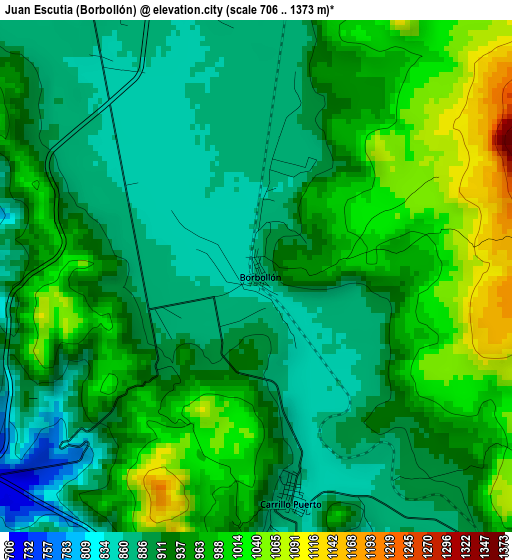
Below is the Elevation map of Juan Escutia (Borbollón), which displays elevation range with different colors. Scale of the first map is from 706 to 1373 m (2316 to 4505 ft) with average elevation of 937.2 meters (=3075 ft) [note 1]
These maps also provides idea of topography and contour of this city, they are displayed at different zoom levels. More info about maps, scale and edge coordinates you can find below images.
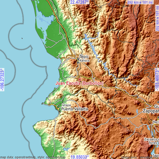
| \ | Map #1 | Topo.Map |
| Scale [m] | 706..1373 m | × |
| Scale [ft] | 2316..4505 ft | × |
| Average | 937.2 m = 3075 ft | × |
| Width | 9.11 km = 5.7 mi | 291.6 km = 181.2 mi |
| Height | 9.11 km = 5.7 mi | 291.6 km = 181.2 mi |
| ↑Max Latitude | 21.208385° | 22.47287° |
| Latitude at center | 21.16741° | 21.16741° |
| ↓Min Latitude | 21.126424° | 19.85033° |
| ← Min Longitude | -104.910925° | -106.27323° |
| Longitude center | -104.86698° | -104.86698° |
| →Max Longitude | -104.823035° | -103.46073° |
Nearby cities:
Cities around Juan Escutia (Borbollón) sort by population:
• Compostela elevation 855 m
8.5 km,  336°
336°
• Las Varas 27 m
27.9 km,  272°
272°
• San Pedro Lagunillas 1293 m
13.2 km,  64°
64°
• La Labor 1058 m
27.5 km,  33°
33°
• Testerazo 1029 m
26.3 km,  353°
353°
• Emiliano Zapata 1062 m
22.5 km, 347°
• Chapalilla 891 m
23.9 km,  84°
84°
• Santa Isabel 820 m
25.2 km,  91°
91°
• Felipe Carrillo Puerto 855 m
4 km,  170°
170°
• Zapotán 815 m
8.7 km,  176°
176°
• Aquiles Serdán 984 m
24 km, 354°
• Tetitlán 767 m
26.4 km,  99°
99°
Multilingual:
 En español:
Juan Escutia (Borbollón) elevación 863 m.
 En France:
Juan Escutia (Borbollón) élévation 863 m.
 Auf Deutsch:
Juan Escutia (Borbollón) höhe über dem Meeresspiegel ist 863 m.
 На русском:
Juan Escutia (Borbollón) высота над уровнем моря 863 м
Sources and notes:
- [note 1] Map square and city borders are not equal. Map elevation data is calculated only from area inside that square.
- [src 1] Elevation data from geonames database provided with same terms of usage.
- [src 2] The elevation map of Juan Escutia (Borbollón) is generated using elevation data from NASA's 3 arcsec (90m) resolution SRTM data.
- [src 3] Base (background) map © OpenStreetMap contributors tiles are generated by Geofabrik and OpenTopoMap.
Copyright & License:
This Juan Escutia (Borbollón) Elevation Map is licensed under CC BY-SA. You may reuse any part from this page, if you give a proper credit by linking to this URL:
 More info on terms of use page.