Jala elevation
Jala (Nayarit), Mexico elevation is 1070 meters and Jala elevation in feet is 3510 ft above sea level [src 1]. Jala is a seat of a second-order administrative division (feature code) with elevation that is 244 meters (801 ft) smaller than average city elevation in Mexico.
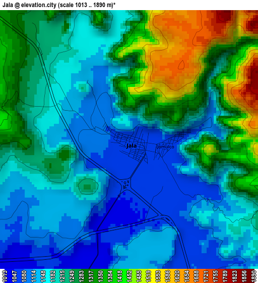
Below is the Elevation map of Jala, which displays elevation range with different colors. Scale of the first map is from 1013 to 1890 m (3323 to 6201 ft) with average elevation of 1233.7 meters (=4048 ft) [note 1]
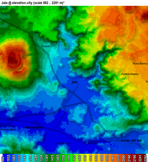
These maps also provides idea of topography and contour of this city, they are displayed at different zoom levels. More info about maps, scale and edge coordinates you can find below images.
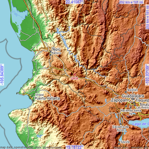
| \ | Map #1 | Map #2 | Topo.Map |
| Scale [m] | 1013..1890 m | 982..2291 m | × |
| Scale [ft] | 3323..6201 ft | 3222..7516 ft | × |
| Average | 1233.7 m = 4048 ft | 1407.8 m = 4619 ft | × |
| Width | 9.12 km = 5.7 mi | 18.23 km = 11.3 mi | 291.7 km = 181.3 mi |
| Height | 9.12 km = 5.7 mi | 18.23 km = 11.3 mi | 291.7 km = 181.3 mi |
| ↑Max Latitude | 21.145832° | 21.186813° | 22.41087° |
| Latitude at center | 21.10484° | 21.10484° | 21.10484° |
| ↓Min Latitude | 21.063837° | 21.022822° | 19.78722° |
| ← Min Longitude | -104.481585° | -104.525531° | -105.84389° |
| Longitude center | -104.43764° | -104.43764° | -104.43764° |
| →Max Longitude | -104.393695° | -104.349749° | -103.03139° |
Nearby cities:
Cities around Jala sort by population:
• Ixtlán del Río elevation 1049 m
10.1 km,  136°
136°
• Ahuacatlán 999 m
7.4 km,  220°
220°
• Jomulco 1068 m
1.4 km,  93°
93°
• Rosa Blanca 1939 m
8.5 km,  75°
75°
• Uzeta 775 m
17.1 km,  273°
273°
• El Rosario 777 m
23.9 km,  187°
187°
• Chapalilla 891 m
22.7 km,  294°
294°
• Méxpan 1027 m
8 km,  162°
162°
• Santa Isabel 820 m
20.4 km, 288°
• Los Aguajes 1909 m
8.6 km, 88°
• Tequepexpan 1463 m
18.4 km,  312°
312°
• Tetitlán 767 m
18.7 km,  278°
278°
Multilingual:
 En español:
Jala elevación 1070 m.
 En France:
Jala élévation 1070 m.


Sources and notes:
- [note 1] Map square and city borders are not equal. Map elevation data is calculated only from area inside that square.
- [src 1] Elevation data from geonames database provided with same terms of usage.
- [src 2] The elevation map of Jala is generated using elevation data from NASA's 3 arcsec (90m) resolution SRTM data.
- [src 3] Base (background) map © OpenStreetMap contributors tiles are generated by Geofabrik and OpenTopoMap.
Copyright & License:
This Jala Elevation Map is licensed under CC BY-SA. You may reuse any part from this page, if you give a proper credit by linking to this URL:
 More info on terms of use page.