Chinampas elevation
Chinampas (Jalisco, Ojuelos de Jalisco), Mexico elevation is 2122 meters and Chinampas elevation in feet is 6962 ft above sea level [src 1]. Chinampas is a populated place (feature code) with elevation that is 808 meters (2651 ft) bigger than average city elevation in Mexico.
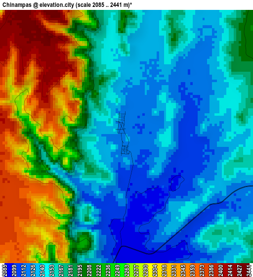
Below is the Elevation map of Chinampas, which displays elevation range with different colors. Scale of the first map is from 2085 to 2441 m (6841 to 8009 ft) with average elevation of 2197.1 meters (=7208 ft) [note 1]
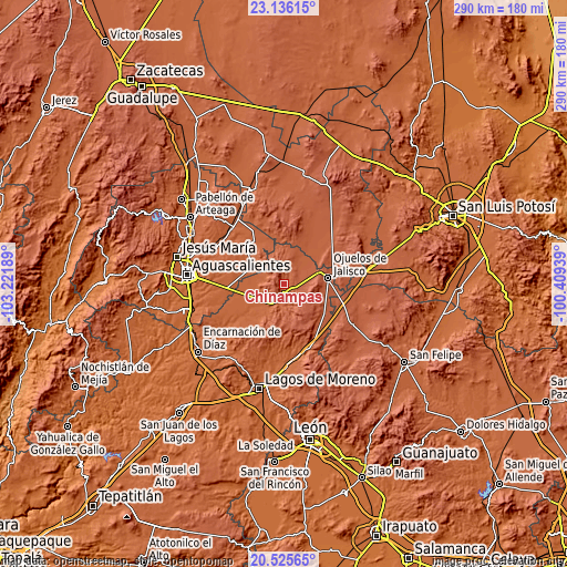
These maps also provides idea of topography and contour of this city, they are displayed at different zoom levels. More info about maps, scale and edge coordinates you can find below images.
| \ | Map #1 | Topo.Map |
| Scale [m] | 2085..2441 m | × |
| Scale [ft] | 6841..8009 ft | × |
| Average | 2197.1 m = 7208 ft | × |
| Width | 9.07 km = 5.6 mi | 290.3 km = 180.4 mi |
| Height | 9.07 km = 5.6 mi | 290.3 km = 180.4 mi |
| ↑Max Latitude | 21.877646° | 23.13615° |
| Latitude at center | 21.83686° | 21.83686° |
| ↓Min Latitude | 21.796062° | 20.52565° |
| ← Min Longitude | -101.859585° | -103.22189° |
| Longitude center | -101.81564° | -101.81564° |
| →Max Longitude | -101.771695° | -100.40939° |
Nearby cities:
Cities around Chinampas sort by population:
• Ojuelos de Jalisco elevation 2226 m
23.2 km,  81°
81°
• Palo Alto 2026 m
17.8 km,  300°
300°
• Matancillas (San Isidro Matancillas) 2180 m
18 km,  70°
70°
• Los Azulitos 2013 m
15.5 km,  273°
273°
• Betulia 1994 m
22.7 km,  247°
247°
• La Paz 2127 m
5.4 km,  115°
115°
• Francisco Primo de Verdad (Ciénega de Mata) 2086 m
10.3 km,  186°
186°
• La Presa 2090 m
6.8 km,  179°
179°
• Los Conos 2003 m
19.7 km,  289°
289°
• San Cristóbal 2019 m
21.6 km,  216°
216°
• Ojo de Agua de Crucitas 2066 m
20 km,  315°
315°
• Vaquerías 2279 m
18.4 km,  114°
114°
Multilingual:
 En español:
Chinampas elevación 2122 m.
 En France:
Chinampas élévation 2122 m.
 Auf Deutsch:
Chinampas höhe über dem Meeresspiegel ist 2122 m.

Sources and notes:
- [note 1] Map square and city borders are not equal. Map elevation data is calculated only from area inside that square.
- [src 1] Elevation data from geonames database provided with same terms of usage.
- [src 2] The elevation map of Chinampas is generated using elevation data from NASA's 3 arcsec (90m) resolution SRTM data.
- [src 3] Base (background) map © OpenStreetMap contributors tiles are generated by Geofabrik and OpenTopoMap.
Copyright & License:
This Chinampas Elevation Map is licensed under CC BY-SA. You may reuse any part from this page, if you give a proper credit by linking to this URL:
 More info on terms of use page.