Churintzio elevation
Churintzio (Michoacán), Mexico elevation is 1858 meters and Churintzio elevation in feet is 6096 ft above sea level [src 1]. Churintzio is a populated place (feature code) with elevation that is 544 meters (1785 ft) bigger than average city elevation in Mexico.
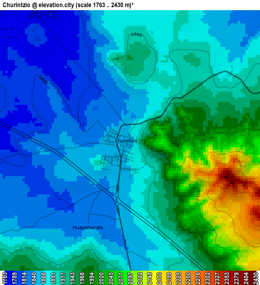
Below is the Elevation map of Churintzio, which displays elevation range with different colors. Scale of the first map is from 1763 to 2430 m (5784 to 7972 ft) with average elevation of 1904.9 meters (=6250 ft) [note 1]
These maps also provides idea of topography and contour of this city, they are displayed at different zoom levels. More info about maps, scale and edge coordinates you can find below images.
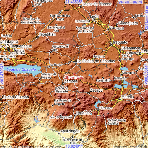
| \ | Map #1 | Topo.Map |
| Scale [m] | 1763..2430 m | × |
| Scale [ft] | 5784..7972 ft | × |
| Average | 1904.9 m = 6250 ft | × |
| Width | 9.17 km = 5.7 mi | 293.6 km = 182.4 mi |
| Height | 9.17 km = 5.7 mi | 293.6 km = 182.4 mi |
| ↑Max Latitude | 20.19181° | 21.46505° |
| Latitude at center | 20.15056° | 20.15056° |
| ↓Min Latitude | 20.109299° | 18.82491° |
| ← Min Longitude | -102.108635° | -103.47094° |
| Longitude center | -102.06469° | -102.06469° |
| →Max Longitude | -102.020745° | -100.65844° |
Nearby cities:
Cities around Churintzio sort by population:
• Numarán elevation 1686 m
16.7 km,  45°
45°
• Ecuandureo 1582 m
13.5 km,  275°
275°
• Penjamillo de Degollado 1704 m
14.5 km,  110°
110°
• Atecucario de la Constitución (Atecuario) 1591 m
20.5 km,  242°
242°
• Tlazazalca 1798 m
20 km,  178°
178°
• Las Cañadas 1719 m
18.7 km,  28°
28°
• Zináparo 1846 m
7.4 km,  70°
70°
• Ziquítaro 1826 m
20.7 km,  118°
118°
• Atacheo de Regalado 1621 m
16.4 km,  231°
231°
• Cañada de Ramírez 1703 m
19.3 km, 33°
• Los Guajes 1750 m
14.7 km,  326°
326°
• Guándaro 1695 m
20.4 km,  76°
76°
Multilingual:
 En español:
Churintzio elevación 1858 m.
 En France:
Churintzio élévation 1858 m.
 Auf Deutsch:
Churintzio höhe über dem Meeresspiegel ist 1858 m.

Sources and notes:
- [note 1] Map square and city borders are not equal. Map elevation data is calculated only from area inside that square.
- [src 1] Elevation data from geonames database provided with same terms of usage.
- [src 2] The elevation map of Churintzio is generated using elevation data from NASA's 3 arcsec (90m) resolution SRTM data.
- [src 3] Base (background) map © OpenStreetMap contributors tiles are generated by Geofabrik and OpenTopoMap.
Copyright & License:
This Churintzio Elevation Map is licensed under CC BY-SA. You may reuse any part from this page, if you give a proper credit by linking to this URL:
 More info on terms of use page.