Ecuandureo elevation
Ecuandureo (Michoacán), Mexico elevation is 1582 meters and Ecuandureo elevation in feet is 5190 ft above sea level [src 1]. Ecuandureo is a populated place (feature code) with elevation that is 268 meters (879 ft) bigger than average city elevation in Mexico.
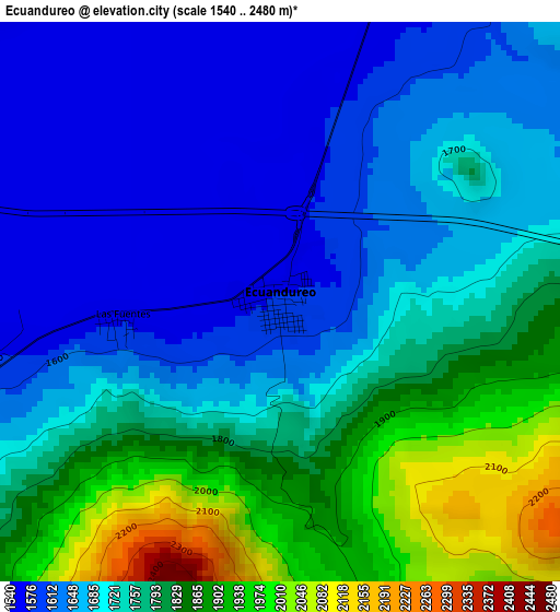
Below is the Elevation map of Ecuandureo, which displays elevation range with different colors. Scale of the first map is from 1540 to 2480 m (5052 to 8136 ft) with average elevation of 1732.5 meters (=5684 ft) [note 1]
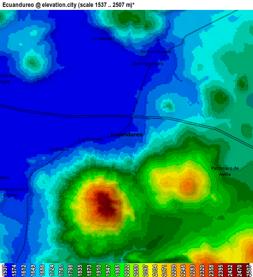
These maps also provides idea of topography and contour of this city, they are displayed at different zoom levels. More info about maps, scale and edge coordinates you can find below images.
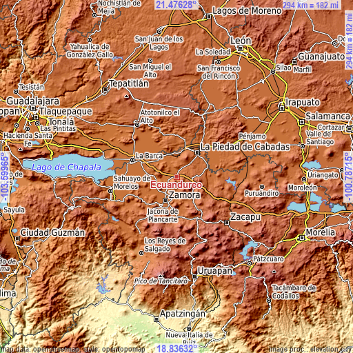
| \ | Map #1 | Map #2 | Topo.Map |
| Scale [m] | 1540..2480 m | 1537..2507 m | × |
| Scale [ft] | 5052..8136 ft | 5043..8225 ft | × |
| Average | 1732.5 m = 5684 ft | 1745.1 m = 5725 ft | × |
| Width | 9.17 km = 5.7 mi | 18.35 km = 11.4 mi | 293.5 km = 182.4 mi |
| Height | 9.17 km = 5.7 mi | 18.35 km = 11.4 mi | 293.6 km = 182.4 mi |
| ↑Max Latitude | 20.203127° | 20.244363° | 21.47628° |
| Latitude at center | 20.16188° | 20.16188° | 20.16188° |
| ↓Min Latitude | 20.120622° | 20.079353° | 18.83632° |
| ← Min Longitude | -102.237345° | -102.281291° | -103.59965° |
| Longitude center | -102.1934° | -102.1934° | -102.1934° |
| →Max Longitude | -102.149455° | -102.105509° | -100.78715° |
Nearby cities:
Cities around Ecuandureo sort by population:
• La Rinconoda elevation 1590 m
16.5 km,  217°
217°
• Atecucario de la Constitución (Atecuario) 1591 m
11.8 km,  203°
203°
• La Sauceda 1575 m
17.6 km,  244°
244°
• Churintzio 1858 m
13.5 km,  95°
95°
• Aquiles Serdán 1587 m
17.8 km,  187°
187°
• El Sauz de Abajo 1578 m
12.4 km, 219°
• Atacheo de Regalado 1621 m
11.5 km,  176°
176°
• Las Cieneguitas 1545 m
11.1 km,  330°
330°
• Los Guajes 1750 m
12.3 km,  26°
26°
• Monteleón 1569 m
16.4 km,  354°
354°
• Romero de Torres 1571 m
16.5 km, 202°
• Romero de Guzmán 1573 m
16.2 km, 204°
Multilingual:
 En español:
Ecuandureo elevación 1582 m.
 En France:
Ecuandureo élévation 1582 m.
 Auf Deutsch:
Ecuandureo höhe über dem Meeresspiegel ist 1582 m.

Sources and notes:
- [note 1] Map square and city borders are not equal. Map elevation data is calculated only from area inside that square.
- [src 1] Elevation data from geonames database provided with same terms of usage.
- [src 2] The elevation map of Ecuandureo is generated using elevation data from NASA's 3 arcsec (90m) resolution SRTM data.
- [src 3] Base (background) map © OpenStreetMap contributors tiles are generated by Geofabrik and OpenTopoMap.
Copyright & License:
This Ecuandureo Elevation Map is licensed under CC BY-SA. You may reuse any part from this page, if you give a proper credit by linking to this URL:
 More info on terms of use page.