El Sauz elevation
El Sauz (Chihuahua), Mexico elevation is 1558 meters and El Sauz elevation in feet is 5112 ft above sea level [src 1]. El Sauz is a populated place (feature code) with elevation that is 244 meters (801 ft) bigger than average city elevation in Mexico.
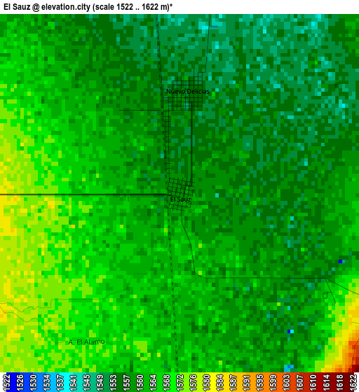
Below is the Elevation map of El Sauz, which displays elevation range with different colors. Scale of the first map is from 1522 to 1622 m (4993 to 5322 ft) with average elevation of 1561.2 meters (=5122 ft) [note 1]
These maps also provides idea of topography and contour of this city, they are displayed at different zoom levels. More info about maps, scale and edge coordinates you can find below images.
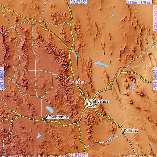
| \ | Map #1 | Topo.Map |
| Scale [m] | 1522..1622 m | × |
| Scale [ft] | 4993..5322 ft | × |
| Average | 1561.2 m = 5122 ft | × |
| Width | 8.54 km = 5.3 mi | 273.4 km = 169.9 mi |
| Height | 8.54 km = 5.3 mi | 273.4 km = 169.9 mi |
| ↑Max Latitude | 29.088969° | 30.2725° |
| Latitude at center | 29.05056° | 29.05056° |
| ↓Min Latitude | 29.012136° | 27.81397° |
| ← Min Longitude | -106.296745° | -107.65905° |
| Longitude center | -106.2528° | -106.2528° |
| →Max Longitude | -106.208855° | -104.84655° |
Nearby cities:
Cities around El Sauz sort by population:
• Chihuahua elevation 1437 m
48.9 km,  160°
160°
• Cuauhtémoc 2051 m
92.9 km,  219°
219°
• Aldama 1269 m
40.6 km,  125°
125°
• Anáhuac 1981 m
79.3 km, 217°
• Lázaro Cárdenas 1202 m
95.7 km,  140°
140°
• Santa Eulalia 1690 m
61.9 km, 144°
• Ninguno [CERESO] 1467 m
57.7 km,  148°
148°
• Benito Juárez 1936 m
69.7 km,  280°
280°
• Santa Isabel 1623 m
79.7 km,  188°
188°
• Ejido La Quemada 2038 m
78.1 km,  253°
253°
• Carretas 1676 m
92.6 km,  195°
195°
• San Andrés 1764 m
61.1 km, 203°
Multilingual:
 En español:
El Sauz elevación 1558 m.
 En France:
El Sauz élévation 1558 m.
 Auf Deutsch:
El Sauz höhe über dem Meeresspiegel ist 1558 m.

Sources and notes:
- [note 1] Map square and city borders are not equal. Map elevation data is calculated only from area inside that square.
- [src 1] Elevation data from geonames database provided with same terms of usage.
- [src 2] The elevation map of El Sauz is generated using elevation data from NASA's 3 arcsec (90m) resolution SRTM data.
- [src 3] Base (background) map © OpenStreetMap contributors tiles are generated by Geofabrik and OpenTopoMap.
Copyright & License:
This El Sauz Elevation Map is licensed under CC BY-SA. You may reuse any part from this page, if you give a proper credit by linking to this URL:
 More info on terms of use page.