Benito Juárez elevation
Benito Juárez (Chihuahua, Namiquipa), Mexico elevation is 1936 meters and Benito Juárez elevation in feet is 6352 ft above sea level [src 1]. Benito Juárez is a populated place (feature code) with elevation that is 622 meters (2041 ft) bigger than average city elevation in Mexico.
Below is the Elevation map of Benito Juárez, which displays elevation range with different colors. Scale of the first map is from 1889 to 2030 m (6198 to 6660 ft) with average elevation of 1952.9 meters (=6407 ft) [note 1]
These maps also provides idea of topography and contour of this city, they are displayed at different zoom levels. More info about maps, scale and edge coordinates you can find below images.
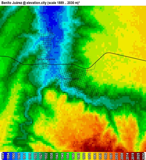
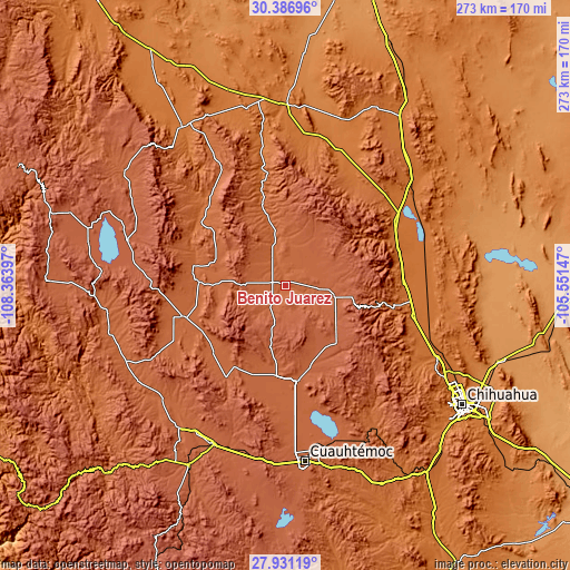
| \ | Map #1 | Topo.Map |
| Scale [m] | 1889..2030 m | × |
| Scale [ft] | 6198..6660 ft | × |
| Average | 1952.9 m = 6407 ft | × |
| Width | 8.53 km = 5.3 mi | 273.1 km = 169.7 mi |
| Height | 8.53 km = 5.3 mi | 273.1 km = 169.7 mi |
| ↑Max Latitude | 29.204786° | 30.38696° |
| Latitude at center | 29.16642° | 29.16642° |
| ↓Min Latitude | 29.128039° | 27.93119° |
| ← Min Longitude | -107.001665° | -108.36397° |
| Longitude center | -106.95772° | -106.95772° |
| →Max Longitude | -106.913775° | -105.55147° |
Nearby cities:
Cities around Benito Juárez sort by population:
• Anáhuac elevation 1981 m
78.6 km,  164°
164°
• Gómez Farías 2148 m
78.8 km,  285°
285°
• Oscar Soto Maynez 1880 m
52.3 km,  253°
253°
• El Terrero 1853 m
41.7 km,  272°
272°
• El Molino 1848 m
43.7 km, 273°
• Bachíniva 2021 m
52.9 km,  213°
213°
• Namiquipa 1837 m
45.3 km,  282°
282°
• El Sauz 1558 m
69.7 km,  100°
100°
• Ejido La Quemada 2038 m
36 km,  189°
189°
• Las Cruces 1751 m
51.3 km,  305°
305°
• Peña Blanca 2164 m
74.4 km, 280°
• Independencia 1951 m
57.5 km,  261°
261°
Multilingual:
 En español:
Benito Juárez elevación 1936 m.
 En France:
Benito Juárez élévation 1936 m.
 Auf Deutsch:
Benito Juárez höhe über dem Meeresspiegel ist 1936 m.

Sources and notes:
- [note 1] Map square and city borders are not equal. Map elevation data is calculated only from area inside that square.
- [src 1] Elevation data from geonames database provided with same terms of usage.
- [src 2] The elevation map of Benito Juárez is generated using elevation data from NASA's 3 arcsec (90m) resolution SRTM data.
- [src 3] Base (background) map © OpenStreetMap contributors tiles are generated by Geofabrik and OpenTopoMap.
Copyright & License:
This Benito Juárez Elevation Map is licensed under CC BY-SA. You may reuse any part from this page, if you give a proper credit by linking to this URL:
 More info on terms of use page.