Empalme Escobedo elevation
Empalme Escobedo (Guanajuato, Comonfort), Mexico elevation is 1790 meters and Empalme Escobedo elevation in feet is 5873 ft above sea level [src 1]. Empalme Escobedo is a populated place (feature code) with elevation that is 476 meters (1562 ft) bigger than average city elevation in Mexico.
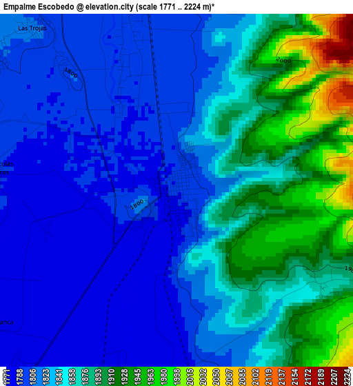
Below is the Elevation map of Empalme Escobedo, which displays elevation range with different colors. Scale of the first map is from 1771 to 2224 m (5810 to 7297 ft) with average elevation of 1846.2 meters (=6057 ft) [note 1]
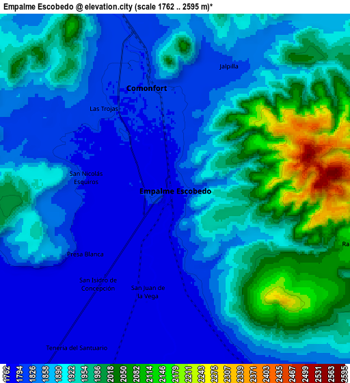
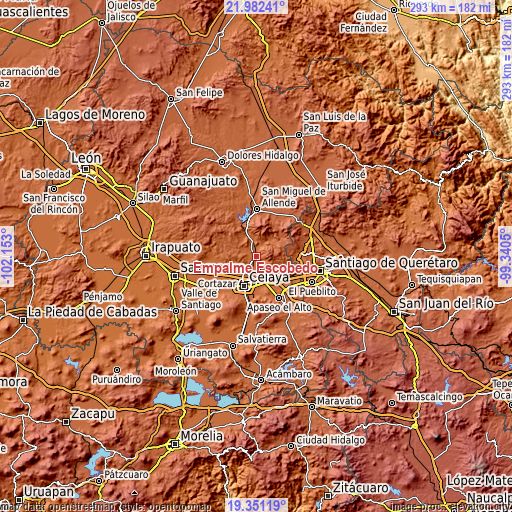
These maps also provides idea of topography and contour of this city, they are displayed at different zoom levels. More info about maps, scale and edge coordinates you can find below images.
| \ | Map #1 | Map #2 | Topo.Map |
| Scale [m] | 1771..2224 m | 1762..2595 m | × |
| Scale [ft] | 5810..7297 ft | 5781..8514 ft | × |
| Average | 1846.2 m = 6057 ft | 1900.8 m = 6236 ft | × |
| Width | 9.14 km = 5.7 mi | 18.29 km = 11.4 mi | 292.6 km = 181.8 mi |
| Height | 9.14 km = 5.7 mi | 18.29 km = 11.4 mi | 292.6 km = 181.8 mi |
| ↑Max Latitude | 20.71361° | 20.754709° | 21.98241° |
| Latitude at center | 20.6725° | 20.6725° | 20.6725° |
| ↓Min Latitude | 20.631379° | 20.590246° | 19.35119° |
| ← Min Longitude | -100.790695° | -100.834641° | -102.153° |
| Longitude center | -100.74675° | -100.74675° | -100.74675° |
| →Max Longitude | -100.702805° | -100.658859° | -99.3405° |
Nearby cities:
Cities around Empalme Escobedo sort by population:
• Comonfort elevation 1800 m
5.7 km,  346°
346°
• San Juan de la Vega 1777 m
5.5 km,  196°
196°
• Tenería del Santuario 1770 m
9.7 km,  213°
213°
• Neutla 1826 m
10.4 km,  292°
292°
• San Antonio Gallardo 1776 m
5.4 km, 204°
• La Aurora 1778 m
5.2 km,  192°
192°
• Jalpilla 1823 m
7.1 km,  22°
22°
• San Isidro de la Concepción 1775 m
6.4 km,  219°
219°
• Presa Blanca 1780 m
5.9 km,  234°
234°
• Orduña de Abajo 1803 m
10.2 km,  338°
338°
• Las Trojas 1804 m
5.6 km,  320°
320°
• Jauregui 1775 m
9.3 km,  162°
162°
Multilingual:
 En español:
Empalme Escobedo elevación 1790 m.
 En France:
Empalme Escobedo élévation 1790 m.
 Auf Deutsch:
Empalme Escobedo höhe über dem Meeresspiegel ist 1790 m.

Sources and notes:
- [note 1] Map square and city borders are not equal. Map elevation data is calculated only from area inside that square.
- [src 1] Elevation data from geonames database provided with same terms of usage.
- [src 2] The elevation map of Empalme Escobedo is generated using elevation data from NASA's 3 arcsec (90m) resolution SRTM data.
- [src 3] Base (background) map © OpenStreetMap contributors tiles are generated by Geofabrik and OpenTopoMap.
Copyright & License:
This Empalme Escobedo Elevation Map is licensed under CC BY-SA. You may reuse any part from this page, if you give a proper credit by linking to this URL:
 More info on terms of use page.