General Cepeda elevation
General Cepeda (Coahuila), Mexico elevation is 1468 meters and General Cepeda elevation in feet is 4816 ft above sea level [src 1]. General Cepeda is a seat of a second-order administrative division (feature code) with elevation that is 154 meters (505 ft) bigger than average city elevation in Mexico.
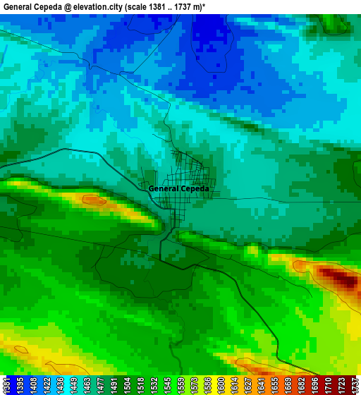
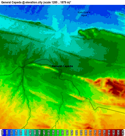
Below is the Elevation map of General Cepeda, which displays elevation range with different colors. Scale of the first map is from 1381 to 1737 m (4531 to 5699 ft) with average elevation of 1486.8 meters (=4878 ft) [note 1]
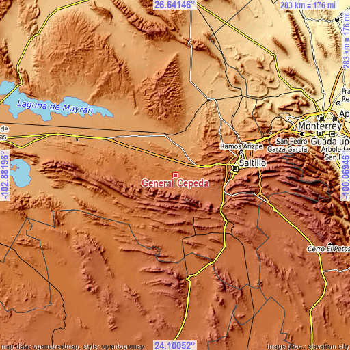
These maps also provides idea of topography and contour of this city, they are displayed at different zoom levels. More info about maps, scale and edge coordinates you can find below images.
| \ | Map #1 | Map #2 | Topo.Map |
| Scale [m] | 1381..1737 m | 1285..1879 m | × |
| Scale [ft] | 4531..5699 ft | 4216..6165 ft | × |
| Average | 1486.8 m = 4878 ft | 1511.1 m = 4958 ft | × |
| Width | 8.83 km = 5.5 mi | 17.66 km = 11 mi | 282.5 km = 175.5 mi |
| Height | 8.83 km = 5.5 mi | 17.66 km = 11 mi | 282.5 km = 175.5 mi |
| ↑Max Latitude | 25.417368° | 25.457053° | 26.64146° |
| Latitude at center | 25.37767° | 25.37767° | 25.37767° |
| ↓Min Latitude | 25.337959° | 25.298235° | 24.10052° |
| ← Min Longitude | -101.519655° | -101.563601° | -102.88196° |
| Longitude center | -101.47571° | -101.47571° | -101.47571° |
| →Max Longitude | -101.431765° | -101.387819° | -100.06946° |
Nearby cities:
Cities around General Cepeda sort by population:
• Saltillo elevation 1592 m
47.5 km,  83°
83°
• Ramos Arizpe 1413 m
56 km,  71°
71°
• Parras de la Fuente 1527 m
70.9 km,  275°
275°
• Arteaga 1679 m
63.6 km, 83°
• Concepción del Oro 2073 m
85.2 km,  176°
176°
• Huachichil 2097 m
67.9 km,  105°
105°
• Agua Nueva 1935 m
44.2 km,  118°
118°
• Terminal de Providencia 1955 m
76.2 km, 179°
• Paredón 775 m
83.3 km,  40°
40°
• San Juan de la Vaquería 1820 m
29.2 km, 118°
• Cedros 1768 m
83.3 km,  201°
201°
• Mazapil 2274 m
82.6 km,  185°
185°
Multilingual:
 En español:
General Cepeda elevación 1468 m.
 En France:
General Cepeda élévation 1468 m.
 Auf Deutsch:
General Cepeda höhe über dem Meeresspiegel ist 1468 m.

Sources and notes:
- [note 1] Map square and city borders are not equal. Map elevation data is calculated only from area inside that square.
- [src 1] Elevation data from geonames database provided with same terms of usage.
- [src 2] The elevation map of General Cepeda is generated using elevation data from NASA's 3 arcsec (90m) resolution SRTM data.
- [src 3] Base (background) map © OpenStreetMap contributors tiles are generated by Geofabrik and OpenTopoMap.
Copyright & License:
This General Cepeda Elevation Map is licensed under CC BY-SA. You may reuse any part from this page, if you give a proper credit by linking to this URL:
 More info on terms of use page.