Paredón elevation
Paredón (Coahuila, Ramos Arizpe), Mexico elevation is 775 meters and Paredón elevation in feet is 2543 ft above sea level [src 1]. Paredón is a populated place (feature code) with elevation that is 539 meters (1768 ft) smaller than average city elevation in Mexico.
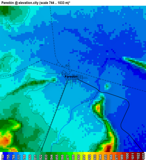
Below is the Elevation map of Paredón, which displays elevation range with different colors. Scale of the first map is from 744 to 1033 m (2441 to 3389 ft) with average elevation of 787 meters (=2582 ft) [note 1]
These maps also provides idea of topography and contour of this city, they are displayed at different zoom levels. More info about maps, scale and edge coordinates you can find below images.
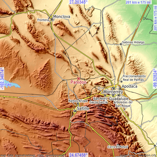
| \ | Map #1 | Topo.Map |
| Scale [m] | 744..1033 m | × |
| Scale [ft] | 2441..3389 ft | × |
| Average | 787 m = 2582 ft | × |
| Width | 8.79 km = 5.5 mi | 281.2 km = 174.7 mi |
| Height | 8.79 km = 5.5 mi | 281.2 km = 174.7 mi |
| ↑Max Latitude | 25.985309° | 27.20345° |
| Latitude at center | 25.9458° | 25.9458° |
| ↓Min Latitude | 25.906277° | 24.67458° |
| ← Min Longitude | -100.978435° | -102.34074° |
| Longitude center | -100.93449° | -100.93449° |
| →Max Longitude | -100.890545° | -99.52824° |
Nearby cities:
Cities around Paredón sort by population:
• García elevation 719 m
36.7 km,  113°
113°
• Ramos Arizpe 1413 m
45.2 km,  181°
181°
• Parque Industrial Ciudad Mitras 593 m
51.7 km, 109°
• Mitras Poniente 592 m
54.3 km, 110°
• Hidalgo 550 m
48.5 km,  86°
86°
• Valle de Lincoln 617 m
48.7 km, 110°
• Mina 591 m
40.9 km,  81°
81°
• Abasolo 511 m
53.9 km, 89°
• Los Parques 619 m
49.6 km, 110°
• Monclova Primer Sector 557 m
55.1 km, 105°
• Praderas de San Francisco 555 m
55.1 km,  104°
104°
• Las Torres de Guadalupe 739 m
34.9 km,  116°
116°
Multilingual:
 En español:
Paredón elevación 775 m.
 En France:
Paredón élévation 775 m.


Sources and notes:
- [note 1] Map square and city borders are not equal. Map elevation data is calculated only from area inside that square.
- [src 1] Elevation data from geonames database provided with same terms of usage.
- [src 2] The elevation map of Paredón is generated using elevation data from NASA's 3 arcsec (90m) resolution SRTM data.
- [src 3] Base (background) map © OpenStreetMap contributors tiles are generated by Geofabrik and OpenTopoMap.
Copyright & License:
This Paredón Elevation Map is licensed under CC BY-SA. You may reuse any part from this page, if you give a proper credit by linking to this URL:
 More info on terms of use page.