General Francisco Villa elevation
General Francisco Villa (Michoacán, Tumbiscatío), Mexico elevation is 280 meters and General Francisco Villa elevation in feet is 919 ft above sea level [src 1]. General Francisco Villa is a populated place (feature code) with elevation that is 1034 meters (3392 ft) smaller than average city elevation in Mexico.
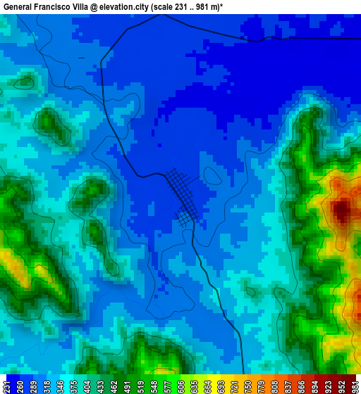
Below is the Elevation map of General Francisco Villa, which displays elevation range with different colors. Scale of the first map is from 231 to 981 m (758 to 3219 ft) with average elevation of 364.1 meters (=1195 ft) [note 1]
These maps also provides idea of topography and contour of this city, they are displayed at different zoom levels. More info about maps, scale and edge coordinates you can find below images.
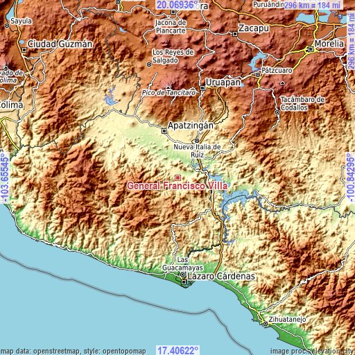
| \ | Map #1 | Topo.Map |
| Scale [m] | 231..981 m | × |
| Scale [ft] | 758..3219 ft | × |
| Average | 364.1 m = 1195 ft | × |
| Width | 9.25 km = 5.7 mi | 296.1 km = 184 mi |
| Height | 9.25 km = 5.7 mi | 296.1 km = 184 mi |
| ↑Max Latitude | 18.78465° | 20.06936° |
| Latitude at center | 18.74304° | 18.74304° |
| ↓Min Latitude | 18.70142° | 17.40622° |
| ← Min Longitude | -102.293145° | -103.65545° |
| Longitude center | -102.2492° | -102.2492° |
| →Max Longitude | -102.205255° | -100.84295° |
Nearby cities:
Cities around General Francisco Villa sort by population:
• La Mira Tumbiscatio elevation 495 m
7.5 km,  208°
208°
• Antúnez (Morelos) 368 m
30.4 km,  9°
9°
• Antúnez 371 m
30.6 km, 8°
• Gambara 279 m
25.5 km,  34°
34°
• Tumbiscatío de Ruiz 919 m
27.6 km, 209°
• El Chauz 232 m
27.6 km,  53°
53°
• El Ceñidor 357 m
29.5 km, 12°
• El Letrero 314 m
28.5 km, 30°
• Cuatro Caminos 358 m
31.3 km, 29°
• Cupuán del Río 230 m
7.5 km,  58°
58°
• San Antonio la Labor 318 m
32.3 km,  350°
350°
• Uspero 311 m
30.2 km,  356°
356°
Multilingual:
 En español:
General Francisco Villa, Las Cruces elevación 280 m.
 En France:
General Francisco Villa élévation 280 m.
 Auf Deutsch:
General Francisco Villa höhe über dem Meeresspiegel ist 280 m.
 На русском:
General Francisco Villa высота над уровнем моря 280 м
Sources and notes:
- [note 1] Map square and city borders are not equal. Map elevation data is calculated only from area inside that square.
- [src 1] Elevation data from geonames database provided with same terms of usage.
- [src 2] The elevation map of General Francisco Villa is generated using elevation data from NASA's 3 arcsec (90m) resolution SRTM data.
- [src 3] Base (background) map © OpenStreetMap contributors tiles are generated by Geofabrik and OpenTopoMap.
Copyright & License:
This General Francisco Villa Elevation Map is licensed under CC BY-SA. You may reuse any part from this page, if you give a proper credit by linking to this URL:
 More info on terms of use page.