Súchil elevation
Súchil (Durango), Mexico elevation is 1976 meters and Súchil elevation in feet is 6483 ft above sea level [src 1]. Súchil is a seat of a second-order administrative division (feature code) with elevation that is 662 meters (2172 ft) bigger than average city elevation in Mexico.
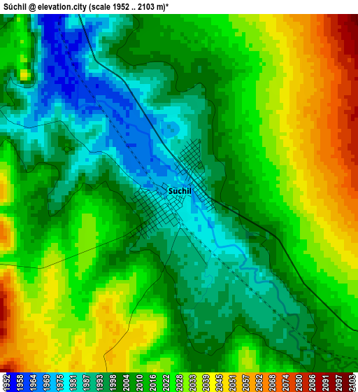
Below is the Elevation map of Súchil, which displays elevation range with different colors. Scale of the first map is from 1952 to 2103 m (6404 to 6900 ft) with average elevation of 2013.1 meters (=6605 ft) [note 1]
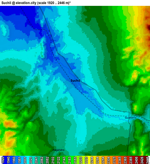
These maps also provides idea of topography and contour of this city, they are displayed at different zoom levels. More info about maps, scale and edge coordinates you can find below images.
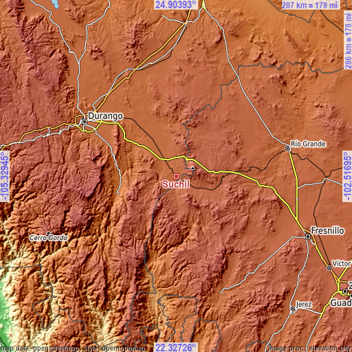
| \ | Map #1 | Map #2 | Topo.Map |
| Scale [m] | 1952..2103 m | 1920..2446 m | × |
| Scale [ft] | 6404..6900 ft | 6299..8025 ft | × |
| Average | 2013.1 m = 6605 ft | 2065 m = 6775 ft | × |
| Width | 8.95 km = 5.6 mi | 17.91 km = 11.1 mi | 286.5 km = 178 mi |
| Height | 8.95 km = 5.6 mi | 17.91 km = 11.1 mi | 286.5 km = 178 mi |
| ↑Max Latitude | 23.662187° | 23.702431° | 24.90393° |
| Latitude at center | 23.62193° | 23.62193° | 23.62193° |
| ↓Min Latitude | 23.581661° | 23.541379° | 22.32726° |
| ← Min Longitude | -103.967145° | -104.011091° | -105.32945° |
| Longitude center | -103.9232° | -103.9232° | -103.9232° |
| →Max Longitude | -103.879255° | -103.835309° | -102.51695° |
Nearby cities:
Cities around Súchil sort by population:
• Sombrerete elevation 2305 m
28.6 km,  87°
87°
• Vicente Guerrero 1925 m
14 km,  333°
333°
• Villa Unión 1906 m
41.2 km,  342°
342°
• Nombre de Dios 1731 m
41.5 km,  307°
307°
• Chalchihuites 2279 m
16.8 km,  165°
165°
• Charco Blanco 2234 m
38.1 km,  45°
45°
• La Joya 1895 m
25.2 km, 342°
• San Francisco Javier 1914 m
16.1 km,  315°
315°
• Orizaba 1891 m
40.3 km, 337°
• Villa Insurgentes (El Calabazal) 2159 m
15.8 km,  31°
31°
• San Martin 2542 m
18.5 km,  72°
72°
• Gabriel Hernández (Mancinas) 1889 m
23.5 km, 333°
Multilingual:
 En español:
Súchil elevación 1976 m.
 En France:
Súchil élévation 1976 m.


Sources and notes:
- [note 1] Map square and city borders are not equal. Map elevation data is calculated only from area inside that square.
- [src 1] Elevation data from geonames database provided with same terms of usage.
- [src 2] The elevation map of Súchil is generated using elevation data from NASA's 3 arcsec (90m) resolution SRTM data.
- [src 3] Base (background) map © OpenStreetMap contributors tiles are generated by Geofabrik and OpenTopoMap.
Copyright & License:
This Súchil Elevation Map is licensed under CC BY-SA. You may reuse any part from this page, if you give a proper credit by linking to this URL:
 More info on terms of use page.