Vicente Guerrero elevation
Vicente Guerrero (Durango), Mexico elevation is 1925 meters and Vicente Guerrero elevation in feet is 6316 ft above sea level [src 1]. Vicente Guerrero is a seat of a second-order administrative division (feature code) with elevation that is 611 meters (2005 ft) bigger than average city elevation in Mexico.
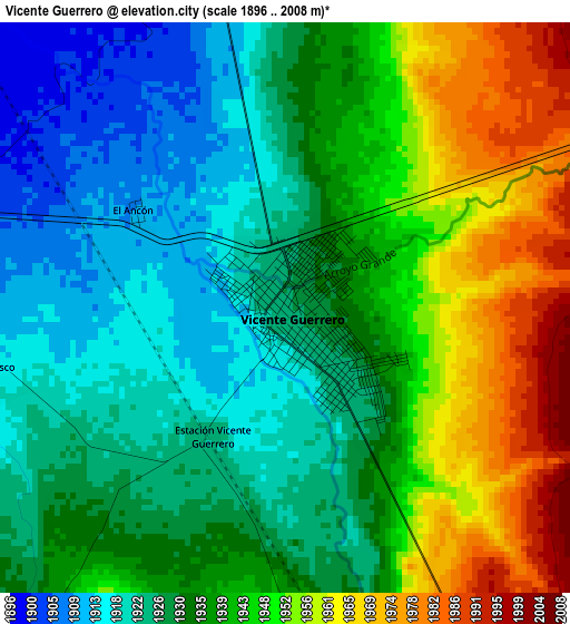
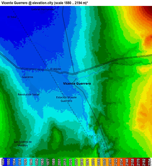
Below is the Elevation map of Vicente Guerrero, which displays elevation range with different colors. Scale of the first map is from 1896 to 2008 m (6220 to 6588 ft) with average elevation of 1937 meters (=6355 ft) [note 1]
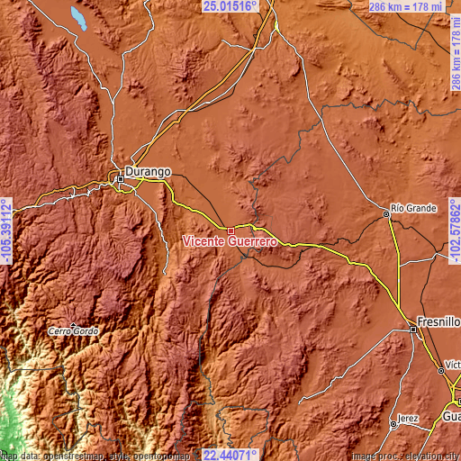
These maps also provides idea of topography and contour of this city, they are displayed at different zoom levels. More info about maps, scale and edge coordinates you can find below images.
| \ | Map #1 | Map #2 | Topo.Map |
| Scale [m] | 1896..2008 m | 1880..2194 m | × |
| Scale [ft] | 6220..6588 ft | 6168..7198 ft | × |
| Average | 1937 m = 6355 ft | 1967.2 m = 6454 ft | × |
| Width | 8.95 km = 5.6 mi | 17.89 km = 11.1 mi | 286.3 km = 177.9 mi |
| Height | 8.95 km = 5.6 mi | 17.89 km = 11.1 mi | 286.3 km = 177.9 mi |
| ↑Max Latitude | 23.774512° | 23.814722° | 25.01516° |
| Latitude at center | 23.73429° | 23.73429° | 23.73429° |
| ↓Min Latitude | 23.694055° | 23.653808° | 22.44071° |
| ← Min Longitude | -104.028815° | -104.072761° | -105.39112° |
| Longitude center | -103.98487° | -103.98487° | -103.98487° |
| →Max Longitude | -103.940925° | -103.896979° | -102.57862° |
Nearby cities:
Cities around Vicente Guerrero sort by population:
• Villa Unión elevation 1906 m
27.5 km,  346°
346°
• Nombre de Dios 1731 m
29.6 km,  295°
295°
• Súchil 1976 m
14 km,  153°
153°
• Chalchihuites 2279 m
30.6 km,  160°
160°
• San Atenógenes (La Villita) 1931 m
28.7 km, 353°
• La Joya 1895 m
11.6 km, 353°
• San Francisco Javier 1914 m
5.1 km,  259°
259°
• Orizaba 1891 m
26.4 km,  339°
339°
• Villa Insurgentes (El Calabazal) 2159 m
14.5 km,  86°
86°
• San Martin 2542 m
24.9 km,  106°
106°
• Gabriel Hernández (Mancinas) 1889 m
9.5 km,  334°
334°
• Narciso Mendoza 1968 m
31.1 km,  3°
3°
Multilingual:
 En español:
Vicente Guerrero elevación 1925 m.
 En France:
Vicente Guerrero élévation 1925 m.
 Auf Deutsch:
Vicente Guerrero höhe über dem Meeresspiegel ist 1925 m.

Sources and notes:
- [note 1] Map square and city borders are not equal. Map elevation data is calculated only from area inside that square.
- [src 1] Elevation data from geonames database provided with same terms of usage.
- [src 2] The elevation map of Vicente Guerrero is generated using elevation data from NASA's 3 arcsec (90m) resolution SRTM data.
- [src 3] Base (background) map © OpenStreetMap contributors tiles are generated by Geofabrik and OpenTopoMap.
Copyright & License:
This Vicente Guerrero Elevation Map is licensed under CC BY-SA. You may reuse any part from this page, if you give a proper credit by linking to this URL:
 More info on terms of use page.