Charco Blanco elevation
Charco Blanco (Zacatecas, Sombrerete), Mexico elevation is 2234 meters and Charco Blanco elevation in feet is 7329 ft above sea level [src 1]. Charco Blanco is a populated place (feature code) with elevation that is 920 meters (3018 ft) bigger than average city elevation in Mexico.
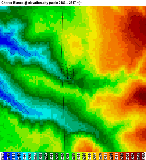
Below is the Elevation map of Charco Blanco, which displays elevation range with different colors. Scale of the first map is from 2183 to 2317 m (7162 to 7602 ft) with average elevation of 2249.2 meters (=7379 ft) [note 1]
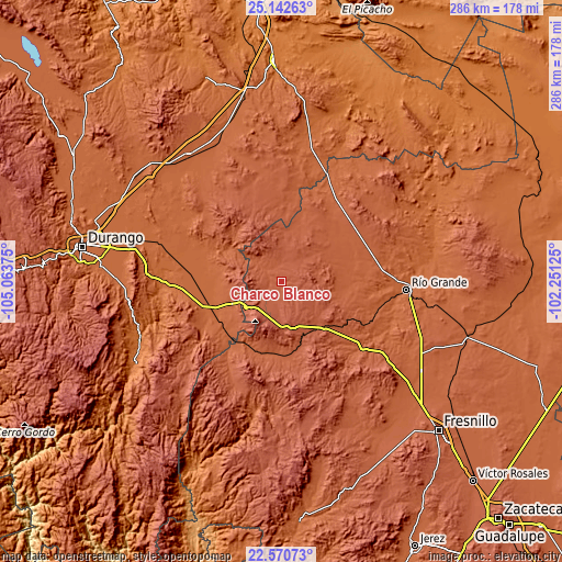
These maps also provides idea of topography and contour of this city, they are displayed at different zoom levels. More info about maps, scale and edge coordinates you can find below images.
| \ | Map #1 | Topo.Map |
| Scale [m] | 2183..2317 m | × |
| Scale [ft] | 7162..7602 ft | × |
| Average | 2249.2 m = 7379 ft | × |
| Width | 8.94 km = 5.6 mi | 286 km = 177.7 mi |
| Height | 8.94 km = 5.6 mi | 286 km = 177.7 mi |
| ↑Max Latitude | 23.903242° | 25.14263° |
| Latitude at center | 23.86306° | 23.86306° |
| ↓Min Latitude | 23.822865° | 22.57073° |
| ← Min Longitude | -103.701445° | -105.06375° |
| Longitude center | -103.6575° | -103.6575° |
| →Max Longitude | -103.613555° | -102.25125° |
Nearby cities:
Cities around Charco Blanco sort by population:
• Sombrerete elevation 2305 m
25.4 km,  176°
176°
• Vicente Guerrero 1925 m
36.3 km,  246°
246°
• Hidalgo 2238 m
12.8 km,  358°
358°
• Ramón Corona 2130 m
36 km,  4°
4°
• Emilio Carranza 2234 m
26.8 km, 357°
• La Joya 1895 m
34.8 km,  265°
265°
• Ignacio Zaragoza 2148 m
26 km,  69°
69°
• Villa Insurgentes (El Calabazal) 2159 m
23.1 km,  234°
234°
• San Martin 2542 m
23.3 km,  203°
203°
• Gabriel Hernández (Mancinas) 1889 m
37.8 km,  261°
261°
• Ejido Zaragoza 2208 m
9.4 km, 356°
• Narciso Mendoza 1968 m
35.5 km,  298°
298°
Multilingual:
 En español:
Charco Blanco elevación 2234 m.
 En France:
Charco Blanco élévation 2234 m.
 Auf Deutsch:
Charco Blanco höhe über dem Meeresspiegel ist 2234 m.

Sources and notes:
- [note 1] Map square and city borders are not equal. Map elevation data is calculated only from area inside that square.
- [src 1] Elevation data from geonames database provided with same terms of usage.
- [src 2] The elevation map of Charco Blanco is generated using elevation data from NASA's 3 arcsec (90m) resolution SRTM data.
- [src 3] Base (background) map © OpenStreetMap contributors tiles are generated by Geofabrik and OpenTopoMap.
Copyright & License:
This Charco Blanco Elevation Map is licensed under CC BY-SA. You may reuse any part from this page, if you give a proper credit by linking to this URL:
 More info on terms of use page.