General Enrique Estrada elevation
General Enrique Estrada (Zacatecas), Mexico elevation is 2151 meters and General Enrique Estrada elevation in feet is 7057 ft above sea level [src 1]. General Enrique Estrada is a seat of a second-order administrative division (feature code) with elevation that is 837 meters (2746 ft) bigger than average city elevation in Mexico.
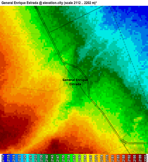
Below is the Elevation map of General Enrique Estrada, which displays elevation range with different colors. Scale of the first map is from 2112 to 2202 m (6929 to 7224 ft) with average elevation of 2157.1 meters (=7077 ft) [note 1]
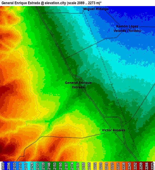
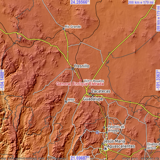
These maps also provides idea of topography and contour of this city, they are displayed at different zoom levels. More info about maps, scale and edge coordinates you can find below images.
| \ | Map #1 | Map #2 | Topo.Map |
| Scale [m] | 2112..2202 m | 2089..2273 m | × |
| Scale [ft] | 6929..7224 ft | 6854..7457 ft | × |
| Average | 2157.1 m = 7077 ft | 2166.2 m = 7107 ft | × |
| Width | 9 km = 5.6 mi | 17.99 km = 11.2 mi | 287.8 km = 178.8 mi |
| Height | 9 km = 5.6 mi | 17.99 km = 11.2 mi | 287.9 km = 178.9 mi |
| ↑Max Latitude | 23.037917° | 23.078351° | 24.28566° |
| Latitude at center | 22.99747° | 22.99747° | 22.99747° |
| ↓Min Latitude | 22.957011° | 22.916541° | 21.69687° |
| ← Min Longitude | -102.786495° | -102.830441° | -104.1488° |
| Longitude center | -102.74255° | -102.74255° | -102.74255° |
| →Max Longitude | -102.698605° | -102.654659° | -101.3363° |
Nearby cities:
Cities around General Enrique Estrada sort by population:
• Fresnillo elevation 2197 m
24.3 km,  327°
327°
• Víctor Rosales 2167 m
6.8 km,  142°
142°
• Morelos 2309 m
20.2 km, 138°
• Pozos de Gamboa 2263 m
18.5 km,  107°
107°
• Hacienda Toribio 2088 m
11.3 km,  32°
32°
• Estación San José 2092 m
21.8 km,  348°
348°
• Hacienda Nueva 2348 m
23.6 km, 144°
• Las Catarinas 2093 m
16.6 km,  51°
51°
• Santiaguillo 2079 m
19 km, 28°
• Casa de Cerros 2253 m
25.9 km,  118°
118°
• Las Pilas 2338 m
22 km, 142°
• Pánuco 2305 m
24.6 km, 123°
Multilingual:
 En español:
General Enrique Estrada elevación 2151 m.
 En France:
General Enrique Estrada élévation 2151 m.
 Auf Deutsch:
General Enrique Estrada höhe über dem Meeresspiegel ist 2151 m.
 На русском:
General Enrique Estrada высота над уровнем моря 2151 м
Sources and notes:
- [note 1] Map square and city borders are not equal. Map elevation data is calculated only from area inside that square.
- [src 1] Elevation data from geonames database provided with same terms of usage.
- [src 2] The elevation map of General Enrique Estrada is generated using elevation data from NASA's 3 arcsec (90m) resolution SRTM data.
- [src 3] Base (background) map © OpenStreetMap contributors tiles are generated by Geofabrik and OpenTopoMap.
Copyright & License:
This General Enrique Estrada Elevation Map is licensed under CC BY-SA. You may reuse any part from this page, if you give a proper credit by linking to this URL:
 More info on terms of use page.