Pánuco elevation
Pánuco (Zacatecas), Mexico elevation is 2305 meters and Pánuco elevation in feet is 7562 ft above sea level [src 1]. Pánuco is a seat of a second-order administrative division (feature code) with elevation that is 991 meters (3251 ft) bigger than average city elevation in Mexico.
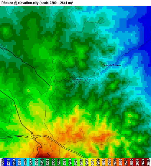
Below is the Elevation map of Pánuco, which displays elevation range with different colors. Scale of the first map is from 2200 to 2641 m (7218 to 8665 ft) with average elevation of 2358.1 meters (=7737 ft) [note 1]
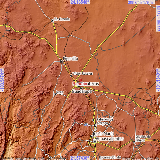
These maps also provides idea of topography and contour of this city, they are displayed at different zoom levels. More info about maps, scale and edge coordinates you can find below images.
| \ | Map #1 | Topo.Map |
| Scale [m] | 2200..2641 m | × |
| Scale [ft] | 7218..8665 ft | × |
| Average | 2358.1 m = 7737 ft | × |
| Width | 9 km = 5.6 mi | 288.1 km = 179 mi |
| Height | 9 km = 5.6 mi | 288.1 km = 179 mi |
| ↑Max Latitude | 22.916593° | 24.16548° |
| Latitude at center | 22.87611° | 22.87611° |
| ↓Min Latitude | 22.835615° | 21.57438° |
| ← Min Longitude | -102.585105° | -103.94741° |
| Longitude center | -102.54116° | -102.54116° |
| →Max Longitude | -102.497215° | -101.13491° |
Nearby cities:
Cities around Pánuco sort by population:
• Zacatecas elevation 2480 m
12.7 km,  199°
199°
• Morelos 2309 m
7.3 km,  257°
257°
• Pozos de Gamboa 2263 m
8.6 km,  339°
339°
• Hacienda Nueva 2348 m
9 km,  230°
230°
• San Antonio del Cipres 2166 m
8.9 km,  38°
38°
• Sauceda de La Borda 2298 m
6.4 km,  142°
142°
• El Lampotal 2089 m
12.7 km,  80°
80°
• Santa Rita 2084 m
13.2 km,  72°
72°
• San José de la Era 2126 m
12.5 km,  103°
103°
• Casa de Cerros 2253 m
2.3 km,  64°
64°
• Las Pilas 2338 m
8.4 km,  241°
241°
• Vetagrande 2544 m
4.9 km, 198°
Multilingual:
 En español:
Panuco, Pánuco elevación 2305 m.
 En France:
Pánuco élévation 2305 m.


Sources and notes:
- [note 1] Map square and city borders are not equal. Map elevation data is calculated only from area inside that square.
- [src 1] Elevation data from geonames database provided with same terms of usage.
- [src 2] The elevation map of Pánuco is generated using elevation data from NASA's 3 arcsec (90m) resolution SRTM data.
- [src 3] Base (background) map © OpenStreetMap contributors tiles are generated by Geofabrik and OpenTopoMap.
Copyright & License:
This Pánuco Elevation Map is licensed under CC BY-SA. You may reuse any part from this page, if you give a proper credit by linking to this URL:
 More info on terms of use page.