Fresnillo elevation
Fresnillo (Zacatecas), Mexico elevation is 2197 meters and Fresnillo elevation in feet is 7208 ft above sea level [src 1]. Fresnillo is a seat of a second-order administrative division (feature code) with elevation that is 883 meters (2897 ft) bigger than average city elevation in Mexico.
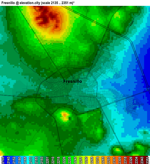
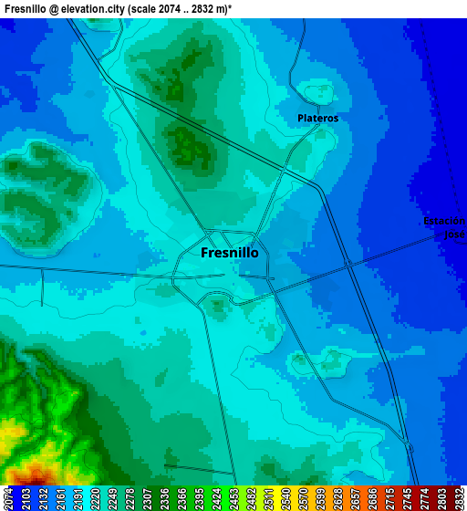
Below is the Elevation map of Fresnillo, which displays elevation range with different colors. Scale of the first map is from 2135 to 2351 m (7005 to 7713 ft) with average elevation of 2204 meters (=7231 ft) [note 1]
These maps also provides idea of topography and contour of this city, they are displayed at different zoom levels. More info about maps, scale and edge coordinates you can find below images.
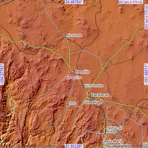
| \ | Map #1 | Map #2 | Topo.Map |
| Scale [m] | 2135..2351 m | 2074..2832 m | × |
| Scale [ft] | 7005..7713 ft | 6804..9291 ft | × |
| Average | 2204 m = 7231 ft | 2201.7 m = 7223 ft | × |
| Width | 8.98 km = 5.6 mi | 17.97 km = 11.2 mi | 287.5 km = 178.6 mi |
| Height | 8.98 km = 5.6 mi | 17.97 km = 11.2 mi | 287.5 km = 178.6 mi |
| ↑Max Latitude | 23.221651° | 23.26203° | 24.46764° |
| Latitude at center | 23.18126° | 23.18126° | 23.18126° |
| ↓Min Latitude | 23.140857° | 23.100441° | 21.88239° |
| ← Min Longitude | -102.915305° | -102.959251° | -104.27761° |
| Longitude center | -102.87136° | -102.87136° | -102.87136° |
| →Max Longitude | -102.827415° | -102.783469° | -101.46511° |
Nearby cities:
Cities around Fresnillo sort by population:
• San Jose de Lourdes elevation 2044 m
17.7 km,  306°
306°
• Plateros 2175 m
6.1 km,  28°
28°
• Río Florido 2034 m
21.9 km,  326°
326°
• General Enrique Estrada 2151 m
24.3 km,  147°
147°
• Hacienda Toribio 2088 m
22.1 km,  119°
119°
• Estación San José 2092 m
8.9 km,  83°
83°
• El Salto 2079 m
20.1 km,  274°
274°
• Altamira 2029 m
25.2 km, 332°
• Santiaguillo 2079 m
22.7 km,  99°
99°
• Colonia Plenitud 2060 m
21.6 km,  285°
285°
• José María Morelos 2040 m
21.5 km,  317°
317°
• Carrillo 2123 m
12.1 km,  282°
282°
Multilingual:
 En español:
Fresnillo elevación 2197 m.
 En France:
Fresnillo élévation 2197 m.
 Auf Deutsch:
Fresnillo höhe über dem Meeresspiegel ist 2197 m.

Sources and notes:
- [note 1] Map square and city borders are not equal. Map elevation data is calculated only from area inside that square.
- [src 1] Elevation data from geonames database provided with same terms of usage.
- [src 2] The elevation map of Fresnillo is generated using elevation data from NASA's 3 arcsec (90m) resolution SRTM data.
- [src 3] Base (background) map © OpenStreetMap contributors tiles are generated by Geofabrik and OpenTopoMap.
Copyright & License:
This Fresnillo Elevation Map is licensed under CC BY-SA. You may reuse any part from this page, if you give a proper credit by linking to this URL:
 More info on terms of use page.