San Luis Taxhimay elevation
San Luis Taxhimay (State of Mexico, Villa del Carbón), Mexico elevation is 2248 meters and San Luis Taxhimay elevation in feet is 7375 ft above sea level [src 1]. San Luis Taxhimay is a populated place (feature code) with elevation that is 934 meters (3064 ft) bigger than average city elevation in Mexico.
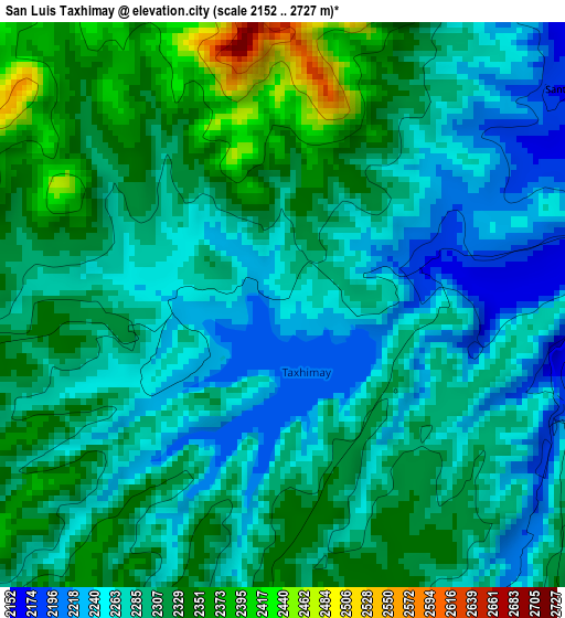
Below is the Elevation map of San Luis Taxhimay, which displays elevation range with different colors. Scale of the first map is from 2152 to 2727 m (7060 to 8947 ft) with average elevation of 2296.7 meters (=7535 ft) [note 1]
These maps also provides idea of topography and contour of this city, they are displayed at different zoom levels. More info about maps, scale and edge coordinates you can find below images.
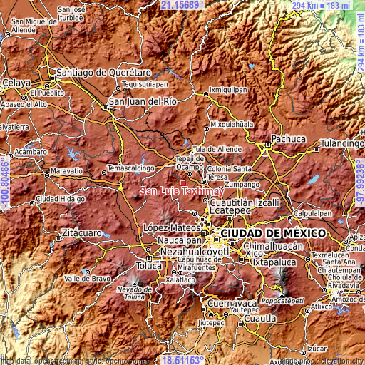
| \ | Map #1 | Topo.Map |
| Scale [m] | 2152..2727 m | × |
| Scale [ft] | 7060..8947 ft | × |
| Average | 2296.7 m = 7535 ft | × |
| Width | 9.19 km = 5.7 mi | 294.1 km = 182.7 mi |
| Height | 9.19 km = 5.7 mi | 294.2 km = 182.8 mi |
| ↑Max Latitude | 19.881052° | 21.15689° |
| Latitude at center | 19.83972° | 19.83972° |
| ↓Min Latitude | 19.798378° | 18.51153° |
| ← Min Longitude | -99.442555° | -100.80486° |
| Longitude center | -99.39861° | -99.39861° |
| →Max Longitude | -99.354665° | -97.99236° |
Nearby cities:
Cities around San Luis Taxhimay sort by population:
• Tepeji del Río de Ocampo elevation 2161 m
9.2 km,  38°
38°
• Tianguistengo (La Romera) 2139 m
11.2 km, 42°
• San Buenaventura 2205 m
8.3 km,  104°
104°
• Tinajas 2266 m
7.2 km,  27°
27°
• Santa María Quelites 2170 m
5.6 km,  73°
73°
• Santiago Tlapanaloya 2160 m
6.1 km,  55°
55°
• Loma Alta Taxhimay 2279 m
1 km,  285°
285°
• Cantera de Villagrán 2231 m
9.4 km,  89°
89°
• San Luis Anáhuac (Toriles) 2361 m
4.8 km,  182°
182°
• San Ignacio Nopala 2168 m
5.6 km, 95°
• Santa Ana Azcapotzaltongo 2194 m
11.6 km,  5°
5°
• La Cruz y Carrizal 2258 m
2.6 km,  246°
246°
Multilingual:
 En español:
San Luis Taxhimay elevación 2248 m.
 En France:
San Luis Taxhimay élévation 2248 m.
 Auf Deutsch:
San Luis Taxhimay höhe über dem Meeresspiegel ist 2248 m.
 На русском:
San Luis Taxhimay высота над уровнем моря 2248 м
Sources and notes:
- [note 1] Map square and city borders are not equal. Map elevation data is calculated only from area inside that square.
- [src 1] Elevation data from geonames database provided with same terms of usage.
- [src 2] The elevation map of San Luis Taxhimay is generated using elevation data from NASA's 3 arcsec (90m) resolution SRTM data.
- [src 3] Base (background) map © OpenStreetMap contributors tiles are generated by Geofabrik and OpenTopoMap.
Copyright & License:
This San Luis Taxhimay Elevation Map is licensed under CC BY-SA. You may reuse any part from this page, if you give a proper credit by linking to this URL:
 More info on terms of use page.