San Buenaventura elevation
San Buenaventura (Hidalgo, Tepeji del Río de Ocampo), Mexico elevation is 2205 meters and San Buenaventura elevation in feet is 7234 ft above sea level [src 1]. San Buenaventura is a populated place (feature code) with elevation that is 891 meters (2923 ft) bigger than average city elevation in Mexico.
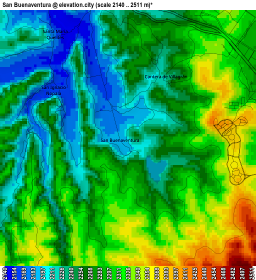
Below is the Elevation map of San Buenaventura, which displays elevation range with different colors. Scale of the first map is from 2140 to 2511 m (7021 to 8238 ft) with average elevation of 2275.7 meters (=7466 ft) [note 1]
These maps also provides idea of topography and contour of this city, they are displayed at different zoom levels. More info about maps, scale and edge coordinates you can find below images.
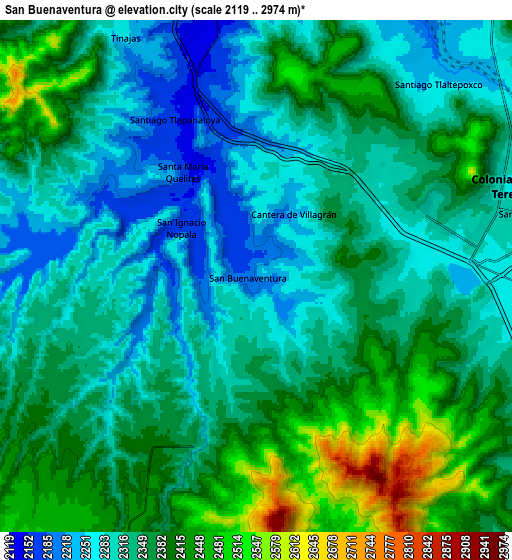
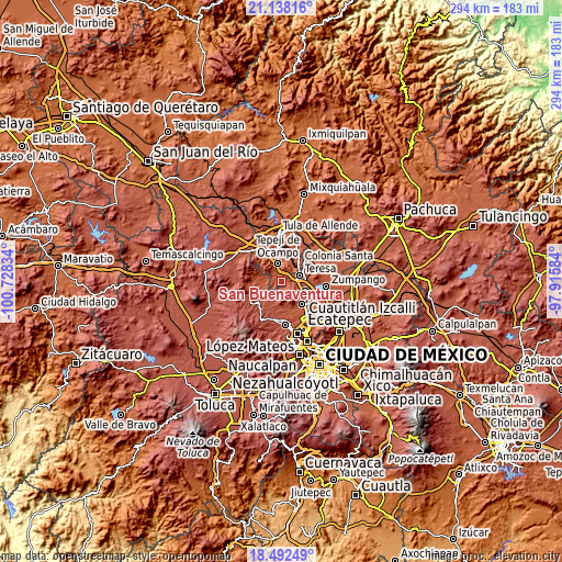
| \ | Map #1 | Map #2 | Topo.Map |
| Scale [m] | 2140..2511 m | 2119..2974 m | × |
| Scale [ft] | 7021..8238 ft | 6952..9757 ft | × |
| Average | 2275.7 m = 7466 ft | 2349.1 m = 7707 ft | × |
| Width | 9.19 km = 5.7 mi | 18.39 km = 11.4 mi | 294.2 km = 182.8 mi |
| Height | 9.19 km = 5.7 mi | 18.39 km = 11.4 mi | 294.2 km = 182.8 mi |
| ↑Max Latitude | 19.862167° | 19.903492° | 21.13816° |
| Latitude at center | 19.82083° | 19.82083° | 19.82083° |
| ↓Min Latitude | 19.779483° | 19.738125° | 18.49249° |
| ← Min Longitude | -99.366035° | -99.409981° | -100.72834° |
| Longitude center | -99.32209° | -99.32209° | -99.32209° |
| →Max Longitude | -99.278145° | -99.234199° | -97.91584° |
Nearby cities:
Cities around San Buenaventura sort by population:
• Tepeji del Río de Ocampo elevation 2161 m
9.6 km,  346°
346°
• Villa URBI del Rey 2352 m
7.2 km,  71°
71°
• Unidad San Miguel Jagüeyes 2389 m
3.5 km,  84°
84°
• Jorobas 2270 m
7.7 km,  87°
87°
• Santiago Tlaltepoxco 2261 m
9.5 km,  42°
42°
• San Luis Taxhimay 2248 m
8.3 km,  284°
284°
• Santa María Quelites 2170 m
4.6 km,  323°
323°
• Santiago Tlapanaloya 2160 m
6.3 km,  331°
331°
• Loma Alta Taxhimay 2279 m
9.3 km, 284°
• Cantera de Villagrán 2231 m
2.6 km,  31°
31°
• San Luis Anáhuac (Toriles) 2361 m
8.6 km,  251°
251°
• San Ignacio Nopala 2168 m
2.9 km,  303°
303°
Multilingual:
 En español:
San Buenaventura elevación 2205 m.
 En France:
San Buenaventura élévation 2205 m.
 Auf Deutsch:
San Buenaventura höhe über dem Meeresspiegel ist 2205 m.

Sources and notes:
- [note 1] Map square and city borders are not equal. Map elevation data is calculated only from area inside that square.
- [src 1] Elevation data from geonames database provided with same terms of usage.
- [src 2] The elevation map of San Buenaventura is generated using elevation data from NASA's 3 arcsec (90m) resolution SRTM data.
- [src 3] Base (background) map © OpenStreetMap contributors tiles are generated by Geofabrik and OpenTopoMap.
Copyright & License:
This San Buenaventura Elevation Map is licensed under CC BY-SA. You may reuse any part from this page, if you give a proper credit by linking to this URL:
 More info on terms of use page.