San Antonio Buenavista elevation
San Antonio Buenavista (State of Mexico, Toluca), Mexico elevation is 2771 meters and San Antonio Buenavista elevation in feet is 9091 ft above sea level [src 1]. San Antonio Buenavista is a populated place (feature code) with elevation that is 1457 meters (4780 ft) bigger than average city elevation in Mexico.
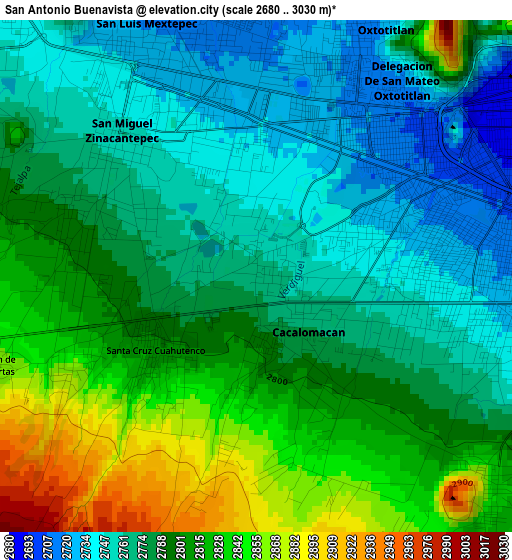
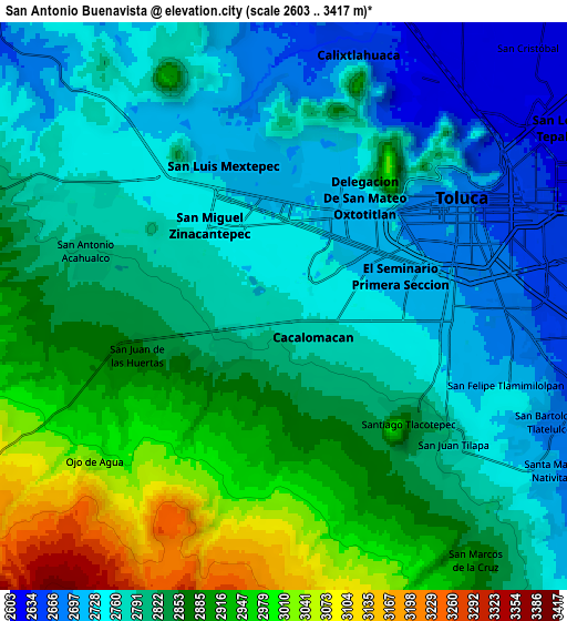
Below is the Elevation map of San Antonio Buenavista, which displays elevation range with different colors. Scale of the first map is from 2680 to 3030 m (8793 to 9941 ft) with average elevation of 2790.9 meters (=9156 ft) [note 1]
These maps also provides idea of topography and contour of this city, they are displayed at different zoom levels. More info about maps, scale and edge coordinates you can find below images.
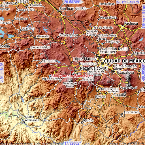
| \ | Map #1 | Map #2 | Topo.Map |
| Scale [m] | 2680..3030 m | 2603..3417 m | × |
| Scale [ft] | 8793..9941 ft | 8540..11211 ft | × |
| Average | 2790.9 m = 9156 ft | 2820.2 m = 9253 ft | × |
| Width | 9.23 km = 5.7 mi | 18.45 km = 11.5 mi | 295.2 km = 183.4 mi |
| Height | 9.23 km = 5.7 mi | 18.45 km = 11.5 mi | 295.2 km = 183.4 mi |
| ↑Max Latitude | 19.30231° | 19.34378° | 20.58289° |
| Latitude at center | 19.26083° | 19.26083° | 19.26083° |
| ↓Min Latitude | 19.219339° | 19.177838° | 17.92802° |
| ← Min Longitude | -99.755885° | -99.799831° | -101.11819° |
| Longitude center | -99.71194° | -99.71194° | -99.71194° |
| →Max Longitude | -99.667995° | -99.624049° | -98.30569° |
Nearby cities:
Cities around San Antonio Buenavista sort by population:
• Zinacantepec elevation 2754 m
3.5 km,  318°
318°
• Santiago Tlacotepec 2833 m
5.7 km,  131°
131°
• San Juan de las Huertas 2864 m
5.1 km,  253°
253°
• Cacalomacan 2772 m
1 km,  145°
145°
• San Buenaventura 2716 m
4.1 km,  82°
82°
• Santa Cruz Cuauhtenco 2803 m
2.3 km,  234°
234°
• La Joya 2795 m
5.2 km,  289°
289°
• Colonia Morelos 2853 m
3.9 km, 245°
• Colonia Ricardo Flores Magón 2811 m
4.9 km,  279°
279°
• Colonia el Refugio 2857 m
4.2 km, 153°
• Cerro del Murciélago 2789 m
5.1 km,  297°
297°
• San José Barbabosa 2749 m
1.9 km,  333°
333°
Multilingual:
 En español:
San Antonio Buenavista elevación 2771 m.
 En France:
San Antonio Buenavista élévation 2771 m.
 Auf Deutsch:
San Antonio Buenavista höhe über dem Meeresspiegel ist 2771 m.
 На русском:
San Antonio Buenavista высота над уровнем моря 2771 м
Sources and notes:
- [note 1] Map square and city borders are not equal. Map elevation data is calculated only from area inside that square.
- [src 1] Elevation data from geonames database provided with same terms of usage.
- [src 2] The elevation map of San Antonio Buenavista is generated using elevation data from NASA's 3 arcsec (90m) resolution SRTM data.
- [src 3] Base (background) map © OpenStreetMap contributors tiles are generated by Geofabrik and OpenTopoMap.
Copyright & License:
This San Antonio Buenavista Elevation Map is licensed under CC BY-SA. You may reuse any part from this page, if you give a proper credit by linking to this URL:
 More info on terms of use page.