Santiago Tlacotepec elevation
Santiago Tlacotepec (State of Mexico, Toluca), Mexico elevation is 2833 meters and Santiago Tlacotepec elevation in feet is 9295 ft above sea level [src 1]. Santiago Tlacotepec is a populated place (feature code) with elevation that is 1519 meters (4984 ft) bigger than average city elevation in Mexico.
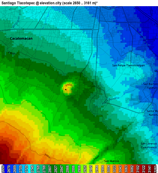
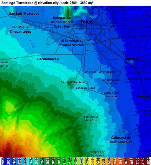
Below is the Elevation map of Santiago Tlacotepec, which displays elevation range with different colors. Scale of the first map is from 2650 to 3161 m (8694 to 10371 ft) with average elevation of 2807.5 meters (=9211 ft) [note 1]
These maps also provides idea of topography and contour of this city, they are displayed at different zoom levels. More info about maps, scale and edge coordinates you can find below images.
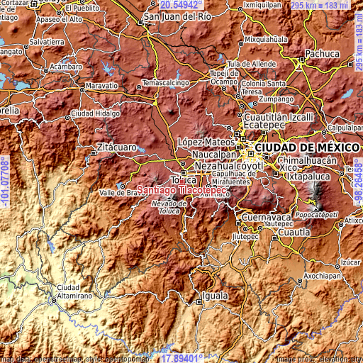
| \ | Map #1 | Map #2 | Topo.Map |
| Scale [m] | 2650..3161 m | 2589..3830 m | × |
| Scale [ft] | 8694..10371 ft | 8494..12566 ft | × |
| Average | 2807.5 m = 9211 ft | 2827.5 m = 9277 ft | × |
| Width | 9.23 km = 5.7 mi | 18.45 km = 11.5 mi | 295.3 km = 183.5 mi |
| Height | 9.23 km = 5.7 mi | 18.45 km = 11.5 mi | 295.3 km = 183.5 mi |
| ↑Max Latitude | 19.268569° | 19.310047° | 20.54942° |
| Latitude at center | 19.22708° | 19.22708° | 19.22708° |
| ↓Min Latitude | 19.185581° | 19.144071° | 17.89401° |
| ← Min Longitude | -99.714775° | -99.758721° | -101.07708° |
| Longitude center | -99.67083° | -99.67083° | -99.67083° |
| →Max Longitude | -99.626885° | -99.582939° | -98.26458° |
Nearby cities:
Cities around Santiago Tlacotepec sort by population:
• San Jorge Pueblo Nuevo elevation 2655 m
5.4 km,  56°
56°
• Cacalomacan 2772 m
4.7 km,  307°
307°
• San Bartolomé Tlaltelulco 2688 m
4.3 km,  89°
89°
• San Buenaventura 2716 m
4.3 km,  356°
356°
• San Felipe Tlalmimilolpan 2726 m
3.3 km,  65°
65°
• San Juan Tilapa 2785 m
1.4 km,  124°
124°
• Santa María Magdalena Ocotitlán 2656 m
5 km,  77°
77°
• Santa María Nativitas 2703 m
4.7 km,  111°
111°
• San Antonio Buenavista 2771 m
5.7 km, 311°
• San Lorenzo Cuauhtenco 2743 m
5.4 km,  130°
130°
• Colonia el Refugio 2857 m
2.5 km,  269°
269°
• San Marcos de la Cruz 2893 m
4.8 km,  158°
158°
Multilingual:
 En español:
Santiago Tlacotepec elevación 2833 m.
 En France:
Santiago Tlacotepec élévation 2833 m.
 Auf Deutsch:
Santiago Tlacotepec höhe über dem Meeresspiegel ist 2833 m.
 На русском:
Santiago Tlacotepec высота над уровнем моря 2833 м
Sources and notes:
- [note 1] Map square and city borders are not equal. Map elevation data is calculated only from area inside that square.
- [src 1] Elevation data from geonames database provided with same terms of usage.
- [src 2] The elevation map of Santiago Tlacotepec is generated using elevation data from NASA's 3 arcsec (90m) resolution SRTM data.
- [src 3] Base (background) map © OpenStreetMap contributors tiles are generated by Geofabrik and OpenTopoMap.
Copyright & License:
This Santiago Tlacotepec Elevation Map is licensed under CC BY-SA. You may reuse any part from this page, if you give a proper credit by linking to this URL:
 More info on terms of use page.