San Agustín Mextepec elevation
San Agustín Mextepec (State of Mexico, San Felipe del Progreso), Mexico elevation is 2587 meters and San Agustín Mextepec elevation in feet is 8488 ft above sea level [src 1]. San Agustín Mextepec is a populated place (feature code) with elevation that is 1273 meters (4177 ft) bigger than average city elevation in Mexico.
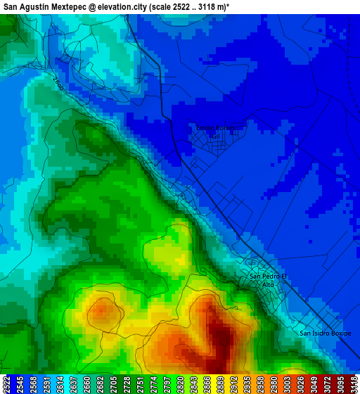
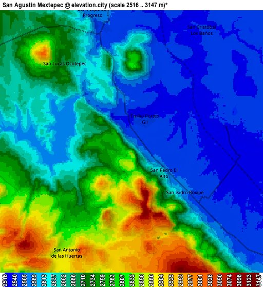
Below is the Elevation map of San Agustín Mextepec, which displays elevation range with different colors. Scale of the first map is from 2522 to 3118 m (8274 to 10230 ft) with average elevation of 2655.2 meters (=8711 ft) [note 1]
These maps also provides idea of topography and contour of this city, they are displayed at different zoom levels. More info about maps, scale and edge coordinates you can find below images.
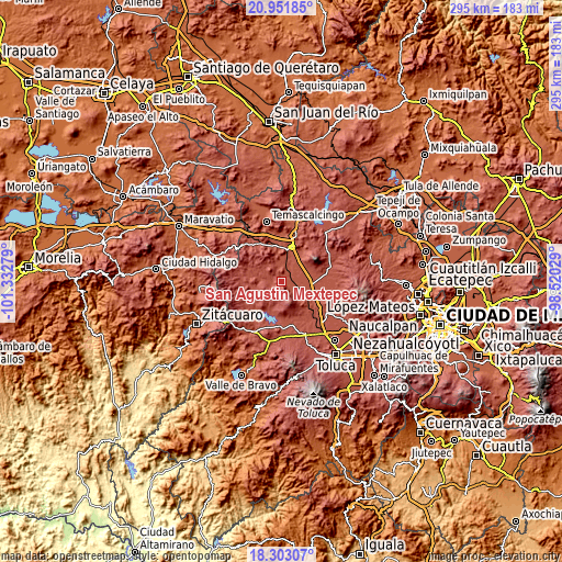
| \ | Map #1 | Map #2 | Topo.Map |
| Scale [m] | 2522..3118 m | 2516..3147 m | × |
| Scale [ft] | 8274..10230 ft | 8255..10325 ft | × |
| Average | 2655.2 m = 8711 ft | 2681.9 m = 8799 ft | × |
| Width | 9.2 km = 5.7 mi | 18.41 km = 11.4 mi | 294.5 km = 183 mi |
| Height | 9.2 km = 5.7 mi | 18.41 km = 11.4 mi | 294.5 km = 183 mi |
| ↑Max Latitude | 19.674305° | 19.71568° | 20.95185° |
| Latitude at center | 19.63292° | 19.63292° | 19.63292° |
| ↓Min Latitude | 19.591524° | 19.550118° | 18.30307° |
| ← Min Longitude | -99.970485° | -100.014431° | -101.33279° |
| Longitude center | -99.92654° | -99.92654° | -99.92654° |
| →Max Longitude | -99.882595° | -99.838649° | -98.52029° |
Nearby cities:
Cities around San Agustín Mextepec sort by population:
• San Pedro el Alto elevation 2598 m
7.2 km,  138°
138°
• Santa Ana Ixtlahuaca (Santa Ana Ixtlahuacingo) 2641 m
6.7 km, 142°
• Emilio Portes Gil 2560 m
1.6 km,  38°
38°
• Dolores Hidalgo 2556 m
2.5 km,  0°
0°
• Santa Ana la Ladera 2542 m
7.2 km,  124°
124°
• San Lucas Ocotepec 2722 m
6.9 km,  316°
316°
• San Jerónimo Bonchete 2769 m
2.4 km,  265°
265°
• San Isidro Boxipe 2579 m
5.1 km,  133°
133°
• Santa Cruz Mextepec 2577 m
4.1 km, 317°
• Guadalupe Coté 2636 m
6.6 km,  248°
248°
• San Juan Cote Ejido 2765 m
4.6 km,  227°
227°
• Barrio Tepetitlán Emilio Portes Gil 2536 m
4.7 km,  61°
61°
Multilingual:
 En español:
San Agustín Mextepec elevación 2587 m.
 En France:
San Agustín Mextepec élévation 2587 m.
 Auf Deutsch:
San Agustín Mextepec höhe über dem Meeresspiegel ist 2587 m.
 На русском:
San Agustín Mextepec высота над уровнем моря 2587 м
Sources and notes:
- [note 1] Map square and city borders are not equal. Map elevation data is calculated only from area inside that square.
- [src 1] Elevation data from geonames database provided with same terms of usage.
- [src 2] The elevation map of San Agustín Mextepec is generated using elevation data from NASA's 3 arcsec (90m) resolution SRTM data.
- [src 3] Base (background) map © OpenStreetMap contributors tiles are generated by Geofabrik and OpenTopoMap.
Copyright & License:
This San Agustín Mextepec Elevation Map is licensed under CC BY-SA. You may reuse any part from this page, if you give a proper credit by linking to this URL:
 More info on terms of use page.