Lindavista elevation
Lindavista (Veracruz, José Azueta), Mexico elevation is 85 meters and Lindavista elevation in feet is 279 ft above sea level [src 1]. Lindavista is a populated place (feature code) with elevation that is 1229 meters (4032 ft) smaller than average city elevation in Mexico.
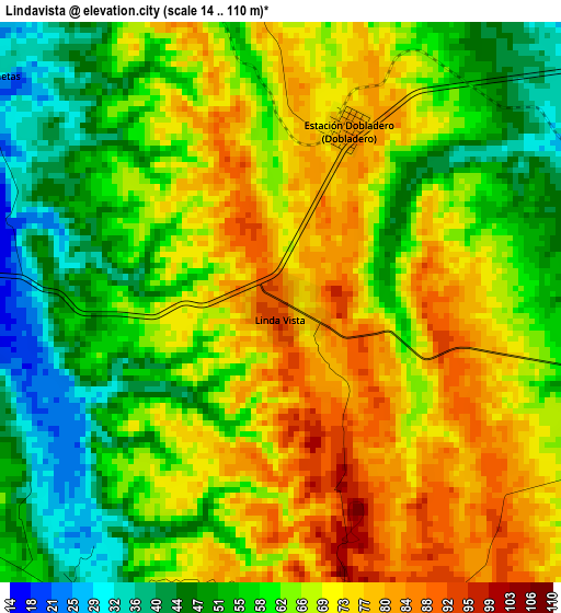
Below is the Elevation map of Lindavista, which displays elevation range with different colors. Scale of the first map is from 14 to 110 m (46 to 361 ft) with average elevation of 63.9 meters (=210 ft) [note 1]
These maps also provides idea of topography and contour of this city, they are displayed at different zoom levels. More info about maps, scale and edge coordinates you can find below images.
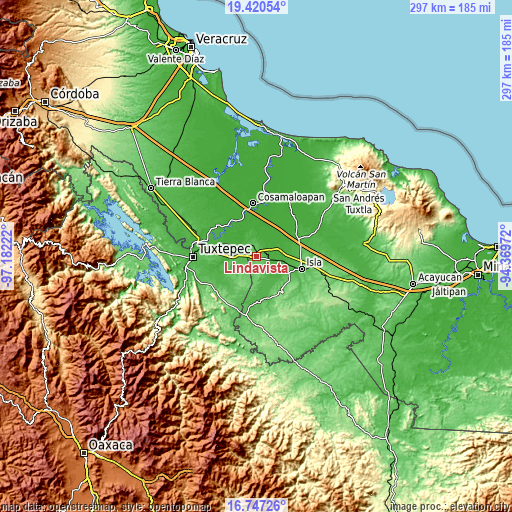
| \ | Map #1 | Topo.Map |
| Scale [m] | 14..110 m | × |
| Scale [ft] | 46..361 ft | × |
| Average | 63.9 m = 210 ft | × |
| Width | 9.29 km = 5.8 mi | 297.2 km = 184.7 mi |
| Height | 9.29 km = 5.8 mi | 297.3 km = 184.7 mi |
| ↑Max Latitude | 18.130758° | 19.42054° |
| Latitude at center | 18.08899° | 18.08899° |
| ↓Min Latitude | 18.047212° | 16.74726° |
| ← Min Longitude | -95.819915° | -97.18222° |
| Longitude center | -95.77597° | -95.77597° |
| →Max Longitude | -95.732025° | -94.36972° |
Nearby cities:
Cities around Lindavista sort by population:
• Loma Bonita elevation 31 m
11.1 km,  280°
280°
• Isla 67 m
26.9 km,  104°
104°
• Tesechoacan 18 m
13.5 km,  66°
66°
• Villa Azueta 32 m
6.9 km, 103°
• Chacaltianguis 15 m
25 km,  343°
343°
• Tlacojalpan 18 m
24 km,  311°
311°
• Benemérito Juárez 32 m
24.1 km, 278°
• Paraiso Novillero 14 m
24.9 km,  317°
317°
• Tuxtilla 14 m
20.9 km, 323°
• Las Sabanetas 28 m
6.5 km, 310°
• Estación Dobladero 84 m
3.1 km,  19°
19°
• San Benito Encinal 81 m
18.2 km,  231°
231°
Multilingual:
 En español:
Lindavista elevación 85 m.
 En France:
Lindavista élévation 85 m.
 Auf Deutsch:
Lindavista höhe über dem Meeresspiegel ist 85 m.

Sources and notes:
- [note 1] Map square and city borders are not equal. Map elevation data is calculated only from area inside that square.
- [src 1] Elevation data from geonames database provided with same terms of usage.
- [src 2] The elevation map of Lindavista is generated using elevation data from NASA's 3 arcsec (90m) resolution SRTM data.
- [src 3] Base (background) map © OpenStreetMap contributors tiles are generated by Geofabrik and OpenTopoMap.
Copyright & License:
This Lindavista Elevation Map is licensed under CC BY-SA. You may reuse any part from this page, if you give a proper credit by linking to this URL:
 More info on terms of use page.