Tuxtilla elevation
Tuxtilla (Veracruz), Mexico elevation is 14 meters and Tuxtilla elevation in feet is 46 ft above sea level [src 1]. Tuxtilla is a seat of a second-order administrative division (feature code) with elevation that is 1300 meters (4265 ft) smaller than average city elevation in Mexico.
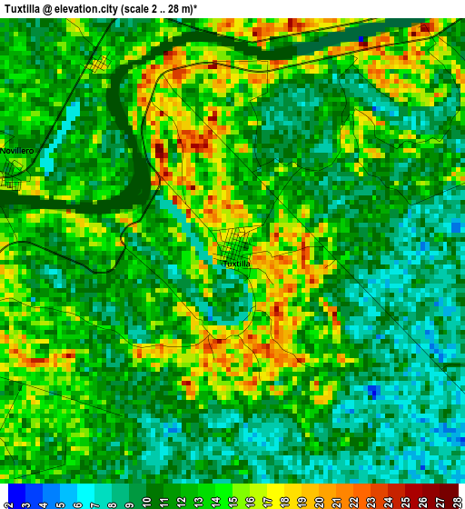
Below is the Elevation map of Tuxtilla, which displays elevation range with different colors. Scale of the first map is from 2 to 28 m (7 to 92 ft) with average elevation of 11.8 meters (=39 ft) [note 1]
These maps also provides idea of topography and contour of this city, they are displayed at different zoom levels. More info about maps, scale and edge coordinates you can find below images.
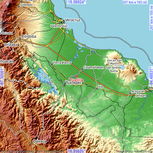
| \ | Map #1 | Topo.Map |
| Scale [m] | 2..28 m | × |
| Scale [ft] | 7..92 ft | × |
| Average | 11.8 m = 39 ft | × |
| Width | 9.28 km = 5.8 mi | 297 km = 184.5 mi |
| Height | 9.28 km = 5.8 mi | 297 km = 184.5 mi |
| ↑Max Latitude | 18.280612° | 19.56924° |
| Latitude at center | 18.23888° | 18.23888° |
| ↓Min Latitude | 18.197137° | 16.89826° |
| ← Min Longitude | -95.938505° | -97.30081° |
| Longitude center | -95.89456° | -95.89456° |
| →Max Longitude | -95.850615° | -94.48831° |
Nearby cities:
Cities around Tuxtilla sort by population:
• Loma Bonita elevation 31 m
14.7 km,  173°
173°
• Cosamaloapan 12 m
17.5 km,  35°
35°
• Otatitlán 23 m
16.2 km,  244°
244°
• Chacaltianguis 15 m
9.3 km, 37°
• Tlacojalpan 18 m
5.6 km,  260°
260°
• Benemérito Juárez 32 m
17.5 km,  220°
220°
• Nopaltepec 24 m
11.8 km,  290°
290°
• Lindavista 85 m
20.9 km,  143°
143°
• Paraiso Novillero 14 m
4.7 km, 289°
• Poblado Dos 20 m
17.7 km,  300°
300°
• Las Sabanetas 28 m
14.6 km,  148°
148°
• Estación Dobladero 84 m
19.3 km, 135°
Multilingual:
 En español:
Tuxtilla elevación 14 m.
 En France:
Tuxtilla élévation 14 m.


Sources and notes:
- [note 1] Map square and city borders are not equal. Map elevation data is calculated only from area inside that square.
- [src 1] Elevation data from geonames database provided with same terms of usage.
- [src 2] The elevation map of Tuxtilla is generated using elevation data from NASA's 3 arcsec (90m) resolution SRTM data.
- [src 3] Base (background) map © OpenStreetMap contributors tiles are generated by Geofabrik and OpenTopoMap.
Copyright & License:
This Tuxtilla Elevation Map is licensed under CC BY-SA. You may reuse any part from this page, if you give a proper credit by linking to this URL:
 More info on terms of use page.