Isla elevation
Isla (Veracruz), Mexico elevation is 67 meters and Isla elevation in feet is 220 ft above sea level [src 1]. Isla is a seat of a second-order administrative division (feature code) with elevation that is 1247 meters (4091 ft) smaller than average city elevation in Mexico.
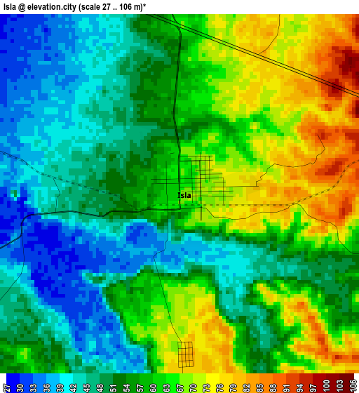
Below is the Elevation map of Isla, which displays elevation range with different colors. Scale of the first map is from 27 to 106 m (89 to 348 ft) with average elevation of 56.9 meters (=187 ft) [note 1]
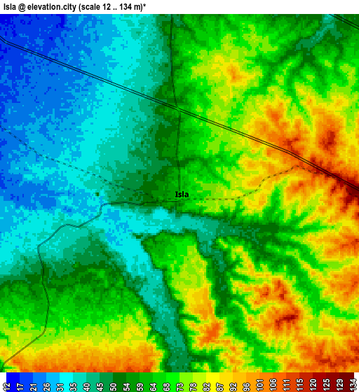
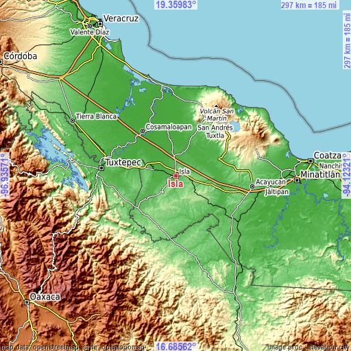
These maps also provides idea of topography and contour of this city, they are displayed at different zoom levels. More info about maps, scale and edge coordinates you can find below images.
| \ | Map #1 | Map #2 | Topo.Map |
| Scale [m] | 27..106 m | 12..134 m | × |
| Scale [ft] | 89..348 ft | 39..440 ft | × |
| Average | 56.9 m = 187 ft | 61.2 m = 201 ft | × |
| Width | 9.29 km = 5.8 mi | 18.59 km = 11.6 mi | 297.3 km = 184.7 mi |
| Height | 9.29 km = 5.8 mi | 18.59 km = 11.6 mi | 297.4 km = 184.8 mi |
| ↑Max Latitude | 18.069583° | 18.111356° | 19.35983° |
| Latitude at center | 18.0278° | 18.0278° | 18.0278° |
| ↓Min Latitude | 17.986007° | 17.944204° | 16.68562° |
| ← Min Longitude | -95.573405° | -95.617351° | -96.93571° |
| Longitude center | -95.52946° | -95.52946° | -95.52946° |
| →Max Longitude | -95.485515° | -95.441569° | -94.12321° |
Nearby cities:
Cities around Isla sort by population:
• Juan Rodríguez Clara elevation 143 m
14.1 km,  105°
105°
• Tesechoacan 18 m
18.3 km,  311°
311°
• Villa Azueta 32 m
20 km,  284°
284°
• Abasolo del Valle 175 m
27.3 km,  183°
183°
• Los Tigres (San Marcos) 188 m
24.4 km,  128°
128°
• Lindavista 85 m
26.9 km, 284°
• Nopalapan 25 m
23 km,  65°
65°
• El Laurel 28 m
34.6 km,  37°
37°
• Las Sabanetas 28 m
32.9 km,  289°
289°
• Huayacanes 188 m
29.3 km, 114°
• Estación Dobladero 84 m
26.8 km, 291°
• El Blanco 41 m
26.8 km,  78°
78°
Multilingual:
 En español:
Isla elevación 67 m.
 En France:
Isla élévation 67 m.


Sources and notes:
- [note 1] Map square and city borders are not equal. Map elevation data is calculated only from area inside that square.
- [src 1] Elevation data from geonames database provided with same terms of usage.
- [src 2] The elevation map of Isla is generated using elevation data from NASA's 3 arcsec (90m) resolution SRTM data.
- [src 3] Base (background) map © OpenStreetMap contributors tiles are generated by Geofabrik and OpenTopoMap.
Copyright & License:
This Isla Elevation Map is licensed under CC BY-SA. You may reuse any part from this page, if you give a proper credit by linking to this URL:
 More info on terms of use page.