Pisaflores elevation
Pisaflores (Veracruz, Ixhuatlán de Madero), Mexico elevation is 189 meters and Pisaflores elevation in feet is 620 ft above sea level [src 1]. Pisaflores is a populated place (feature code) with elevation that is 1125 meters (3691 ft) smaller than average city elevation in Mexico.
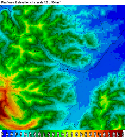
Below is the Elevation map of Pisaflores, which displays elevation range with different colors. Scale of the first map is from 129 to 584 m (423 to 1916 ft) with average elevation of 259.7 meters (=852 ft) [note 1]
These maps also provides idea of topography and contour of this city, they are displayed at different zoom levels. More info about maps, scale and edge coordinates you can find below images.
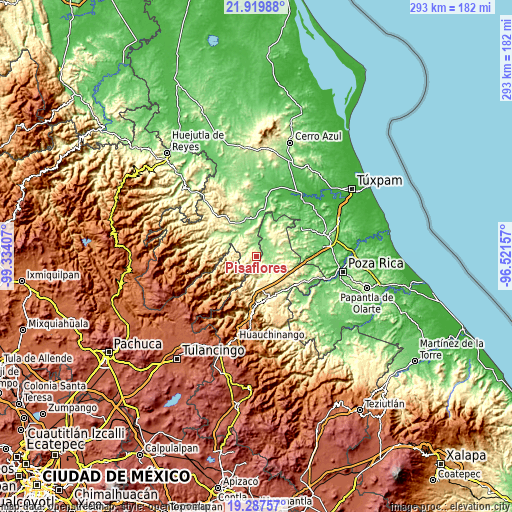
| \ | Map #1 | Topo.Map |
| Scale [m] | 129..584 m | × |
| Scale [ft] | 423..1916 ft | × |
| Average | 259.7 m = 852 ft | × |
| Width | 9.15 km = 5.7 mi | 292.7 km = 181.9 mi |
| Height | 9.15 km = 5.7 mi | 292.7 km = 181.9 mi |
| ↑Max Latitude | 20.650537° | 21.91988° |
| Latitude at center | 20.60941° | 20.60941° |
| ↓Min Latitude | 20.568272° | 19.28757° |
| ← Min Longitude | -97.971765° | -99.33407° |
| Longitude center | -97.92782° | -97.92782° |
| →Max Longitude | -97.883875° | -96.52157° |
Nearby cities:
Cities around Pisaflores sort by population:
• Metlaltoyuca elevation 326 m
16.1 km,  29°
29°
• San Francisco 644 m
10 km,  230°
230°
• Mecapalapa 209 m
11.8 km,  141°
141°
• Pantepec 629 m
9.8 km,  186°
186°
• San Esteban 761 m
15.5 km,  242°
242°
• San Lorenzo Achiotepec 542 m
14.7 km,  264°
264°
• El Zapote Bravo 271 m
9.4 km,  308°
308°
• San Gregorio 845 m
15.5 km,  217°
217°
• Ixhuatlán de Madero 260 m
12.4 km,  315°
315°
• La Pahua 155 m
7.7 km,  88°
88°
• Ameluca 187 m
11.8 km,  115°
115°
• Jaltocan 166 m
11.5 km,  84°
84°
Multilingual:
 En español:
Pisaflores elevación 189 m.
 En France:
Pisaflores élévation 189 m.
 Auf Deutsch:
Pisaflores höhe über dem Meeresspiegel ist 189 m.

Sources and notes:
- [note 1] Map square and city borders are not equal. Map elevation data is calculated only from area inside that square.
- [src 1] Elevation data from geonames database provided with same terms of usage.
- [src 2] The elevation map of Pisaflores is generated using elevation data from NASA's 3 arcsec (90m) resolution SRTM data.
- [src 3] Base (background) map © OpenStreetMap contributors tiles are generated by Geofabrik and OpenTopoMap.
Copyright & License:
This Pisaflores Elevation Map is licensed under CC BY-SA. You may reuse any part from this page, if you give a proper credit by linking to this URL:
 More info on terms of use page.