Mecapalapa elevation
Mecapalapa (Puebla, Pantepec), Mexico elevation is 209 meters and Mecapalapa elevation in feet is 686 ft above sea level [src 1]. Mecapalapa is a populated place (feature code) with elevation that is 1105 meters (3625 ft) smaller than average city elevation in Mexico.
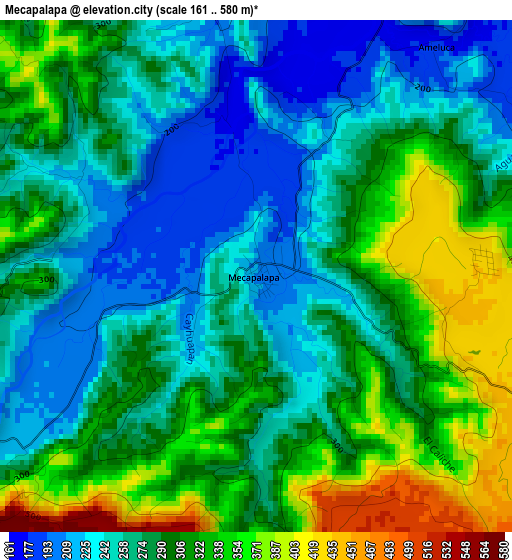
Below is the Elevation map of Mecapalapa, which displays elevation range with different colors. Scale of the first map is from 161 to 580 m (528 to 1903 ft) with average elevation of 289 meters (=948 ft) [note 1]
These maps also provides idea of topography and contour of this city, they are displayed at different zoom levels. More info about maps, scale and edge coordinates you can find below images.
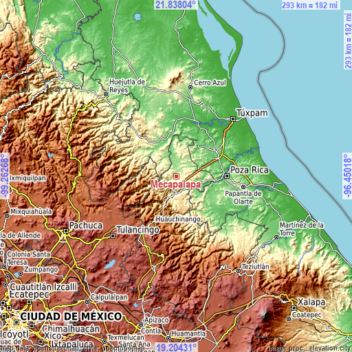
| \ | Map #1 | Topo.Map |
| Scale [m] | 161..580 m | × |
| Scale [ft] | 528..1903 ft | × |
| Average | 289 m = 948 ft | × |
| Width | 9.15 km = 5.7 mi | 292.8 km = 181.9 mi |
| Height | 9.15 km = 5.7 mi | 292.9 km = 182 mi |
| ↑Max Latitude | 20.56799° | 21.83804° |
| Latitude at center | 20.52684° | 20.52684° |
| ↓Min Latitude | 20.485679° | 19.20431° |
| ← Min Longitude | -97.900375° | -99.26268° |
| Longitude center | -97.85643° | -97.85643° |
| →Max Longitude | -97.812485° | -96.45018° |
Nearby cities:
Cities around Mecapalapa sort by population:
• Villa Avila Camacho elevation 244 m
15.9 km,  188°
188°
• San Francisco 644 m
15.4 km,  280°
280°
• Coronel Tito Hernández 186 m
14.8 km,  121°
121°
• Pisaflores 189 m
11.8 km,  321°
321°
• Apapantilla 231 m
13.7 km,  175°
175°
• Pantepec 629 m
8.6 km,  266°
266°
• Papaloctipan 681 m
15.4 km,  222°
222°
• San Pedro Petlacotla 562 m
14.1 km,  205°
205°
• La Pahua 155 m
9.5 km,  1°
1°
• Huitzilac 156 m
14.9 km,  53°
53°
• Ameluca 187 m
5.2 km,  38°
38°
• Jaltocan 166 m
11.1 km,  21°
21°
Multilingual:
 En español:
Mecapalapa elevación 209 m.
 En France:
Mecapalapa élévation 209 m.
 Auf Deutsch:
Mecapalapa höhe über dem Meeresspiegel ist 209 m.

Sources and notes:
- [note 1] Map square and city borders are not equal. Map elevation data is calculated only from area inside that square.
- [src 1] Elevation data from geonames database provided with same terms of usage.
- [src 2] The elevation map of Mecapalapa is generated using elevation data from NASA's 3 arcsec (90m) resolution SRTM data.
- [src 3] Base (background) map © OpenStreetMap contributors tiles are generated by Geofabrik and OpenTopoMap.
Copyright & License:
This Mecapalapa Elevation Map is licensed under CC BY-SA. You may reuse any part from this page, if you give a proper credit by linking to this URL:
 More info on terms of use page.