Pantepec elevation
Pantepec (Puebla), Mexico elevation is 629 meters and Pantepec elevation in feet is 2064 ft above sea level [src 1]. Pantepec is a populated place (feature code) with elevation that is 685 meters (2247 ft) smaller than average city elevation in Mexico.
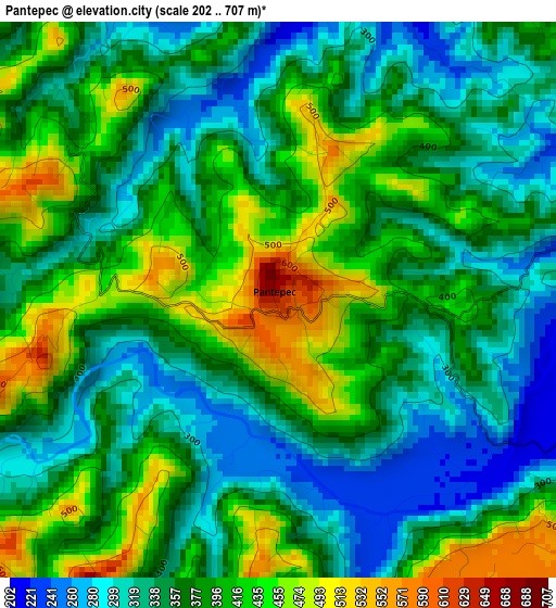
Below is the Elevation map of Pantepec, which displays elevation range with different colors. Scale of the first map is from 202 to 707 m (663 to 2320 ft) with average elevation of 375 meters (=1230 ft) [note 1]
These maps also provides idea of topography and contour of this city, they are displayed at different zoom levels. More info about maps, scale and edge coordinates you can find below images.
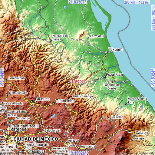
| \ | Map #1 | Topo.Map |
| Scale [m] | 202..707 m | × |
| Scale [ft] | 663..2320 ft | × |
| Average | 375 m = 1230 ft | × |
| Width | 9.15 km = 5.7 mi | 292.9 km = 182 mi |
| Height | 9.15 km = 5.7 mi | 292.9 km = 182 mi |
| ↑Max Latitude | 20.562981° | 21.83307° |
| Latitude at center | 20.52183° | 20.52183° |
| ↓Min Latitude | 20.480668° | 19.19926° |
| ← Min Longitude | -97.982595° | -99.3449° |
| Longitude center | -97.93865° | -97.93865° |
| →Max Longitude | -97.894705° | -96.5324° |
Nearby cities:
Cities around Pantepec sort by population:
• San Francisco elevation 644 m
7.4 km,  297°
297°
• Mecapalapa 209 m
8.6 km,  86°
86°
• Huehuetla 426 m
15.9 km,  244°
244°
• Pisaflores 189 m
9.8 km,  6°
6°
• San Antonio el Grande 780 m
12.4 km,  234°
234°
• San Esteban 761 m
12.9 km,  281°
281°
• Papaloctipan 681 m
11 km,  189°
189°
• San Pedro Petlacotla 562 m
12.5 km,  168°
168°
• San Gregorio 845 m
8.7 km,  252°
252°
• Tlaxco 869 m
14.4 km,  220°
220°
• La Pahua 155 m
13.4 km,  41°
41°
• Ameluca 187 m
12.6 km,  68°
68°
Multilingual:
 En español:
Pantepec elevación 629 m.
 En France:
Pantepec élévation 629 m.
 Auf Deutsch:
Pantepec höhe über dem Meeresspiegel ist 629 m.

Sources and notes:
- [note 1] Map square and city borders are not equal. Map elevation data is calculated only from area inside that square.
- [src 1] Elevation data from geonames database provided with same terms of usage.
- [src 2] The elevation map of Pantepec is generated using elevation data from NASA's 3 arcsec (90m) resolution SRTM data.
- [src 3] Base (background) map © OpenStreetMap contributors tiles are generated by Geofabrik and OpenTopoMap.
Copyright & License:
This Pantepec Elevation Map is licensed under CC BY-SA. You may reuse any part from this page, if you give a proper credit by linking to this URL:
 More info on terms of use page.