San Francisco Nacaxtle elevation
San Francisco Nacaxtle (Veracruz, Comapa), Mexico elevation is 340 meters and San Francisco Nacaxtle elevation in feet is 1115 ft above sea level [src 1]. San Francisco Nacaxtle is a populated place (feature code) with elevation that is 974 meters (3196 ft) smaller than average city elevation in Mexico.
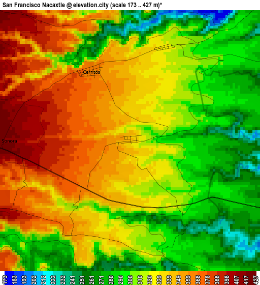
Below is the Elevation map of San Francisco Nacaxtle, which displays elevation range with different colors. Scale of the first map is from 173 to 427 m (568 to 1401 ft) with average elevation of 320.6 meters (=1052 ft) [note 1]
These maps also provides idea of topography and contour of this city, they are displayed at different zoom levels. More info about maps, scale and edge coordinates you can find below images.
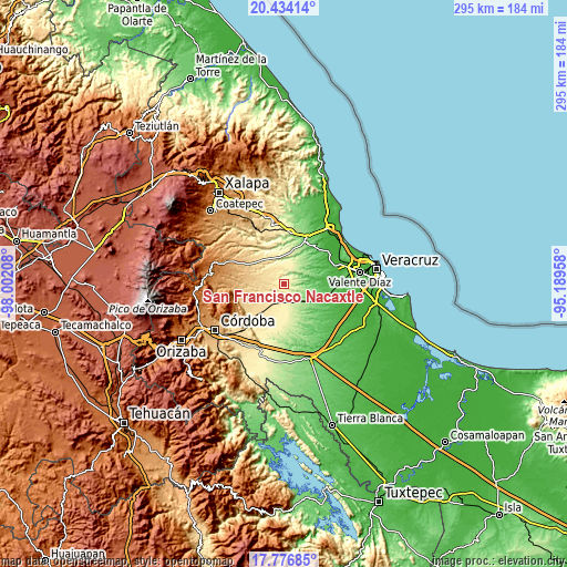
| \ | Map #1 | Topo.Map |
| Scale [m] | 173..427 m | × |
| Scale [ft] | 568..1401 ft | × |
| Average | 320.6 m = 1052 ft | × |
| Width | 9.23 km = 5.7 mi | 295.5 km = 183.6 mi |
| Height | 9.23 km = 5.7 mi | 295.5 km = 183.6 mi |
| ↑Max Latitude | 19.152348° | 20.43414° |
| Latitude at center | 19.11083° | 19.11083° |
| ↓Min Latitude | 19.069301° | 17.77685° |
| ← Min Longitude | -96.639775° | -98.00208° |
| Longitude center | -96.59583° | -96.59583° |
| →Max Longitude | -96.551885° | -95.18958° |
Nearby cities:
Cities around San Francisco Nacaxtle sort by population:
• Paso del Macho elevation 489 m
20.6 km,  220°
220°
• Soledad de Doblado 102 m
19.7 km,  111°
111°
• Tenenexpan 68 m
21.4 km,  80°
80°
• Camarón de Tejeda 352 m
10.1 km,  191°
191°
• Santa María Tatetla 279 m
21.8 km,  325°
325°
• Chavaxtla 841 m
24.8 km,  274°
274°
• Cerritos 360 m
2.9 km, 330°
• Sonora 419 m
4.2 km, 272°
• Loma de los Carmona 50 m
21.2 km,  91°
91°
• Ejido la Piña (Maromilla) 649 m
21.7 km,  245°
245°
• Rincón de Barrabás 223 m
13.2 km,  151°
151°
• Acazónica 342 m
11.4 km,  3°
3°
Multilingual:
 En español:
San Francisco Nacaxtle elevación 340 m.
 En France:
San Francisco Nacaxtle élévation 340 m.
 Auf Deutsch:
San Francisco Nacaxtle höhe über dem Meeresspiegel ist 340 m.
 На русском:
San Francisco Nacaxtle высота над уровнем моря 340 м
Sources and notes:
- [note 1] Map square and city borders are not equal. Map elevation data is calculated only from area inside that square.
- [src 1] Elevation data from geonames database provided with same terms of usage.
- [src 2] The elevation map of San Francisco Nacaxtle is generated using elevation data from NASA's 3 arcsec (90m) resolution SRTM data.
- [src 3] Base (background) map © OpenStreetMap contributors tiles are generated by Geofabrik and OpenTopoMap.
Copyright & License:
This San Francisco Nacaxtle Elevation Map is licensed under CC BY-SA. You may reuse any part from this page, if you give a proper credit by linking to this URL:
 More info on terms of use page.