Soledad de Doblado elevation
Soledad de Doblado (Veracruz), Mexico elevation is 102 meters and Soledad de Doblado elevation in feet is 335 ft above sea level [src 1]. Soledad de Doblado is a seat of a second-order administrative division (feature code) with elevation that is 1212 meters (3976 ft) smaller than average city elevation in Mexico.
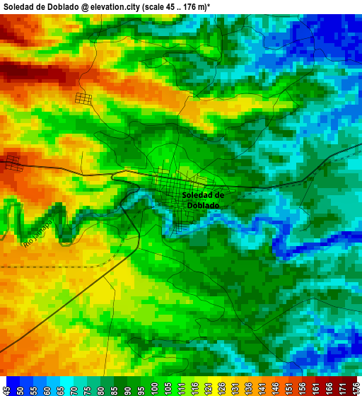
Below is the Elevation map of Soledad de Doblado, which displays elevation range with different colors. Scale of the first map is from 45 to 176 m (148 to 577 ft) with average elevation of 99.9 meters (=328 ft) [note 1]
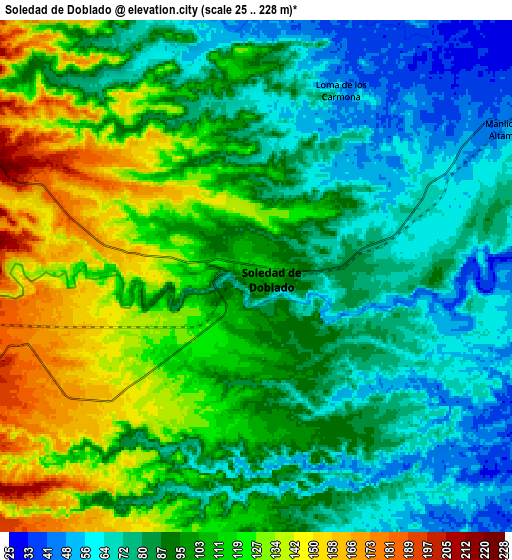
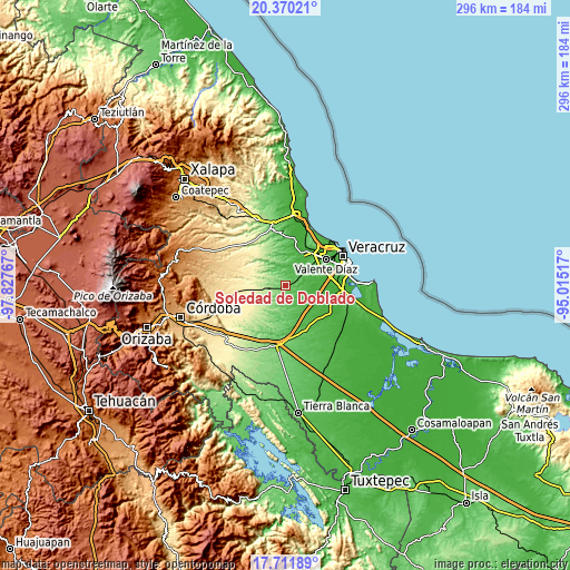
These maps also provides idea of topography and contour of this city, they are displayed at different zoom levels. More info about maps, scale and edge coordinates you can find below images.
| \ | Map #1 | Map #2 | Topo.Map |
| Scale [m] | 45..176 m | 25..228 m | × |
| Scale [ft] | 148..577 ft | 82..748 ft | × |
| Average | 99.9 m = 328 ft | 97.9 m = 321 ft | × |
| Width | 9.24 km = 5.7 mi | 18.48 km = 11.5 mi | 295.6 km = 183.7 mi |
| Height | 9.24 km = 5.7 mi | 18.48 km = 11.5 mi | 295.6 km = 183.7 mi |
| ↑Max Latitude | 19.087904° | 19.129428° | 20.37021° |
| Latitude at center | 19.04637° | 19.04637° | 19.04637° |
| ↓Min Latitude | 19.004825° | 18.96327° | 17.71189° |
| ← Min Longitude | -96.465365° | -96.509311° | -97.82767° |
| Longitude center | -96.42142° | -96.42142° | -96.42142° |
| →Max Longitude | -96.377475° | -96.333529° | -95.01517° |
Nearby cities:
Cities around Soledad de Doblado sort by population:
• Manlio Fabio Altamirano elevation 55 m
10.7 km,  60°
60°
• Jamapa 23 m
18.9 km,  91°
91°
• Puente Jula 22 m
18.7 km,  24°
24°
• Tenenexpan 68 m
10.9 km, 15°
• Camarón de Tejeda 352 m
20.5 km,  262°
262°
• Mata Loma 46 m
16.3 km,  54°
54°
• Cerro Guzmán 28 m
21.5 km,  12°
12°
• Tierra Colorada 18 m
20.7 km, 15°
• Loma de los Carmona 50 m
7.2 km, 23°
• Rincón de Barrabás 223 m
12.9 km,  249°
249°
• San Francisco Nacaxtle 340 m
19.7 km,  291°
291°
• Santa Rita 47 m
21.6 km, 51°
Multilingual:
 En español:
Soledad de Doblado elevación 102 m.
 En France:
Soledad de Doblado élévation 102 m.
 Auf Deutsch:
Soledad de Doblado höhe über dem Meeresspiegel ist 102 m.
 На русском:
Soledad de Doblado высота над уровнем моря 102 м
Sources and notes:
- [note 1] Map square and city borders are not equal. Map elevation data is calculated only from area inside that square.
- [src 1] Elevation data from geonames database provided with same terms of usage.
- [src 2] The elevation map of Soledad de Doblado is generated using elevation data from NASA's 3 arcsec (90m) resolution SRTM data.
- [src 3] Base (background) map © OpenStreetMap contributors tiles are generated by Geofabrik and OpenTopoMap.
Copyright & License:
This Soledad de Doblado Elevation Map is licensed under CC BY-SA. You may reuse any part from this page, if you give a proper credit by linking to this URL:
 More info on terms of use page.