Paso del Macho elevation
Paso del Macho (Veracruz), Mexico elevation is 489 meters and Paso del Macho elevation in feet is 1604 ft above sea level [src 1]. Paso del Macho is a seat of a second-order administrative division (feature code) with elevation that is 825 meters (2707 ft) smaller than average city elevation in Mexico.
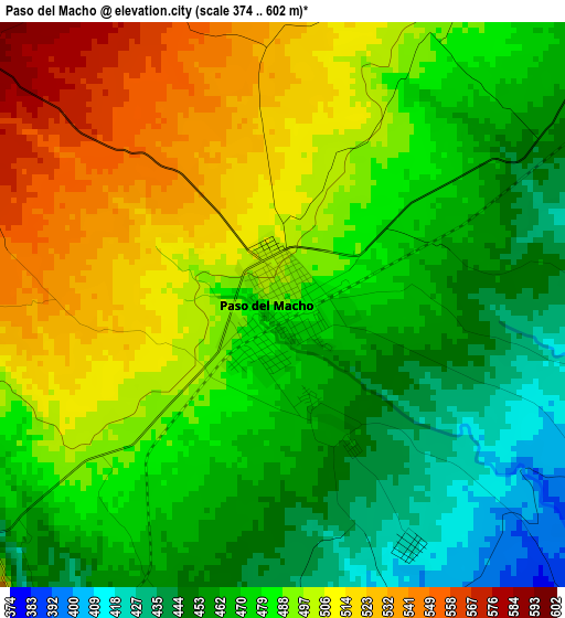
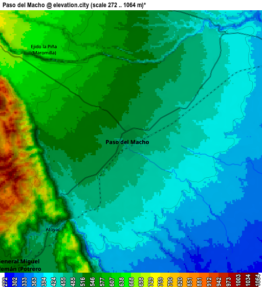
Below is the Elevation map of Paso del Macho, which displays elevation range with different colors. Scale of the first map is from 374 to 602 m (1227 to 1975 ft) with average elevation of 483.7 meters (=1587 ft) [note 1]
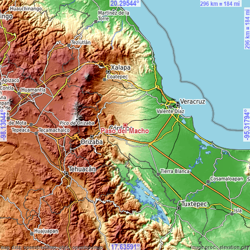
These maps also provides idea of topography and contour of this city, they are displayed at different zoom levels. More info about maps, scale and edge coordinates you can find below images.
| \ | Map #1 | Map #2 | Topo.Map |
| Scale [m] | 374..602 m | 272..1064 m | × |
| Scale [ft] | 1227..1975 ft | 892..3491 ft | × |
| Average | 483.7 m = 1587 ft | 501.3 m = 1645 ft | × |
| Width | 9.24 km = 5.7 mi | 18.48 km = 11.5 mi | 295.7 km = 183.7 mi |
| Height | 9.24 km = 5.7 mi | 18.48 km = 11.5 mi | 295.7 km = 183.7 mi |
| ↑Max Latitude | 19.012533° | 19.054076° | 20.29544° |
| Latitude at center | 18.97098° | 18.97098° | 18.97098° |
| ↓Min Latitude | 18.929416° | 18.887843° | 17.63591° |
| ← Min Longitude | -96.768135° | -96.812081° | -98.13044° |
| Longitude center | -96.72419° | -96.72419° | -96.72419° |
| →Max Longitude | -96.680245° | -96.636299° | -95.31794° |
Nearby cities:
Cities around Paso del Macho sort by population:
• General Miguel Alemán elevation 521 m
11.2 km,  219°
219°
• Yanga 518 m
17.2 km,  206°
206°
• Atoyac 491 m
8.7 km, 221°
• Potrero Viejo 611 m
16.3 km,  230°
230°
• Camarón de Tejeda 352 m
12.8 km,  63°
63°
• San José Tenejapa 1117 m
13.4 km,  291°
291°
• El Maguey 395 m
15.4 km,  183°
183°
• La Palma 751 m
13.7 km,  307°
307°
• Tepatlaxco 833 m
16.7 km, 310°
• Ejido la Piña (Maromilla) 649 m
8.9 km,  315°
315°
• General Alatriste (San Joaquín) 512 m
16.3 km, 206°
• Buena Vista 1238 m
16.1 km,  299°
299°
Multilingual:
 En español:
Paso del Macho elevación 489 m.
 En France:
Paso del Macho élévation 489 m.
 Auf Deutsch:
Paso del Macho höhe über dem Meeresspiegel ist 489 m.

Sources and notes:
- [note 1] Map square and city borders are not equal. Map elevation data is calculated only from area inside that square.
- [src 1] Elevation data from geonames database provided with same terms of usage.
- [src 2] The elevation map of Paso del Macho is generated using elevation data from NASA's 3 arcsec (90m) resolution SRTM data.
- [src 3] Base (background) map © OpenStreetMap contributors tiles are generated by Geofabrik and OpenTopoMap.
Copyright & License:
This Paso del Macho Elevation Map is licensed under CC BY-SA. You may reuse any part from this page, if you give a proper credit by linking to this URL:
 More info on terms of use page.