Yanga elevation
Yanga (Veracruz), Mexico elevation is 518 meters and Yanga elevation in feet is 1699 ft above sea level [src 1]. Yanga is a seat of a second-order administrative division (feature code) with elevation that is 796 meters (2612 ft) smaller than average city elevation in Mexico.
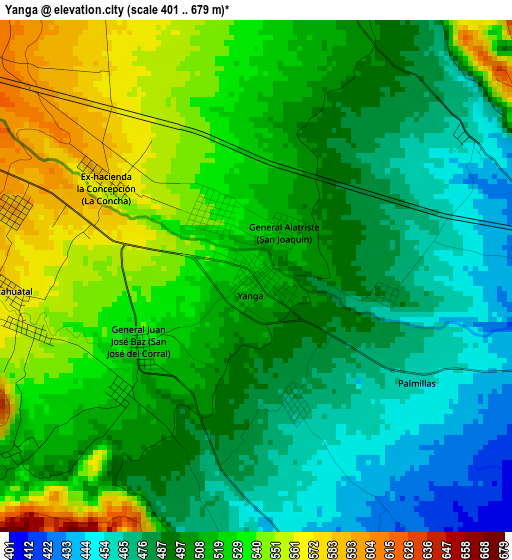
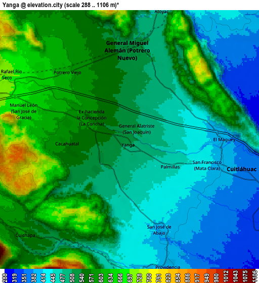
Below is the Elevation map of Yanga, which displays elevation range with different colors. Scale of the first map is from 401 to 679 m (1316 to 2228 ft) with average elevation of 507.6 meters (=1665 ft) [note 1]
These maps also provides idea of topography and contour of this city, they are displayed at different zoom levels. More info about maps, scale and edge coordinates you can find below images.
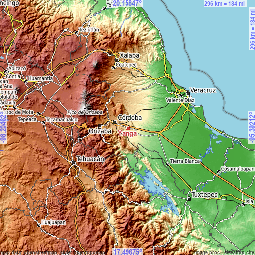
| \ | Map #1 | Map #2 | Topo.Map |
| Scale [m] | 401..679 m | 288..1106 m | × |
| Scale [ft] | 1316..2228 ft | 945..3629 ft | × |
| Average | 507.6 m = 1665 ft | 525.5 m = 1724 ft | × |
| Width | 9.25 km = 5.7 mi | 18.5 km = 11.5 mi | 296 km = 183.9 mi |
| Height | 9.25 km = 5.7 mi | 18.5 km = 11.5 mi | 296 km = 183.9 mi |
| ↑Max Latitude | 18.874468° | 18.916045° | 20.15847° |
| Latitude at center | 18.83288° | 18.83288° | 18.83288° |
| ↓Min Latitude | 18.791282° | 18.749674° | 17.49675° |
| ← Min Longitude | -96.842315° | -96.886261° | -98.20462° |
| Longitude center | -96.79837° | -96.79837° | -96.79837° |
| →Max Longitude | -96.754425° | -96.710479° | -95.39212° |
Nearby cities:
Cities around Yanga sort by population:
• General Miguel Alemán elevation 521 m
6.8 km,  5°
5°
• Cuitláhuac 378 m
8.2 km,  104°
104°
• Manuel León 657 m
8 km,  286°
286°
• Potrero Viejo 611 m
6.9 km,  316°
316°
• San Francisco (Mata Clara) 417 m
5.9 km,  110°
110°
• Palmillas 458 m
3.4 km,  124°
124°
• Cacahuatal 577 m
4.6 km,  267°
267°
• El Maguey 395 m
6.7 km,  89°
89°
• San José de Abajo 408 m
6.7 km,  160°
160°
• Ex-hacienda la Concepción 578 m
3.2 km,  302°
302°
• General Juan José Baz (San José del Corral) 531 m
2.4 km,  238°
238°
• General Alatriste (San Joaquín) 512 m
1 km,  31°
31°
Multilingual:
 En español:
Yanga elevación 518 m.
 En France:
Yanga élévation 518 m.


Sources and notes:
- [note 1] Map square and city borders are not equal. Map elevation data is calculated only from area inside that square.
- [src 1] Elevation data from geonames database provided with same terms of usage.
- [src 2] The elevation map of Yanga is generated using elevation data from NASA's 3 arcsec (90m) resolution SRTM data.
- [src 3] Base (background) map © OpenStreetMap contributors tiles are generated by Geofabrik and OpenTopoMap.
Copyright & License:
This Yanga Elevation Map is licensed under CC BY-SA. You may reuse any part from this page, if you give a proper credit by linking to this URL:
 More info on terms of use page.