Cuitláhuac elevation
Cuitláhuac (Veracruz), Mexico elevation is 378 meters and Cuitláhuac elevation in feet is 1240 ft above sea level [src 1]. Cuitláhuac is a seat of a second-order administrative division (feature code) with elevation that is 936 meters (3071 ft) smaller than average city elevation in Mexico.
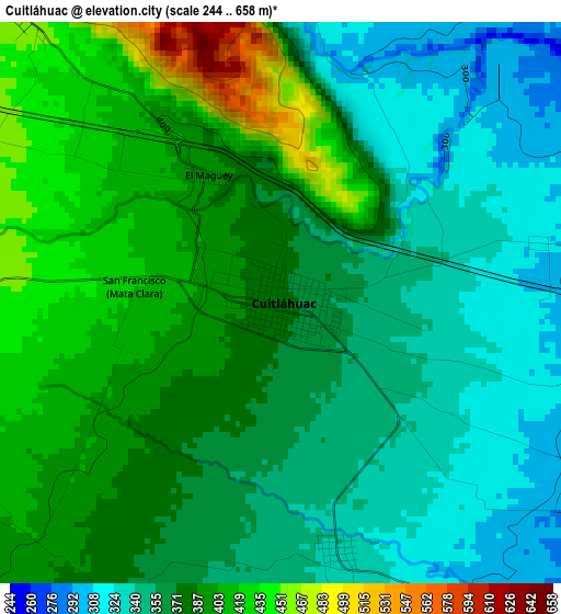
Below is the Elevation map of Cuitláhuac, which displays elevation range with different colors. Scale of the first map is from 244 to 658 m (801 to 2159 ft) with average elevation of 374.9 meters (=1230 ft) [note 1]
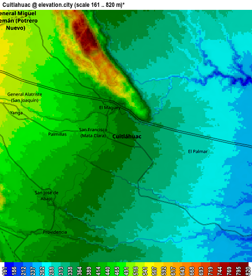
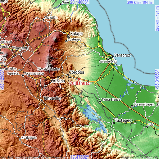
These maps also provides idea of topography and contour of this city, they are displayed at different zoom levels. More info about maps, scale and edge coordinates you can find below images.
| \ | Map #1 | Map #2 | Topo.Map |
| Scale [m] | 244..658 m | 161..820 m | × |
| Scale [ft] | 801..2159 ft | 528..2690 ft | × |
| Average | 374.9 m = 1230 ft | 372.3 m = 1221 ft | × |
| Width | 9.25 km = 5.7 mi | 18.5 km = 11.5 mi | 296 km = 183.9 mi |
| Height | 9.25 km = 5.7 mi | 18.5 km = 11.5 mi | 296 km = 183.9 mi |
| ↑Max Latitude | 18.855882° | 18.897464° | 20.14003° |
| Latitude at center | 18.81429° | 18.81429° | 18.81429° |
| ↓Min Latitude | 18.772688° | 18.731075° | 17.47802° |
| ← Min Longitude | -96.766755° | -96.810701° | -98.12906° |
| Longitude center | -96.72281° | -96.72281° | -96.72281° |
| →Max Longitude | -96.678865° | -96.634919° | -95.31656° |
Nearby cities:
Cities around Cuitláhuac sort by population:
• Yanga elevation 518 m
8.2 km,  284°
284°
• Omealca 423 m
9.9 km,  221°
221°
• La Providencia 402 m
8.5 km, 216°
• San Francisco (Mata Clara) 417 m
2.5 km,  270°
270°
• Palmillas 458 m
5.1 km, 271°
• El Maguey 395 m
2.4 km,  329°
329°
• San José de Abajo 408 m
7.1 km,  233°
233°
• General Juan José Baz (San José del Corral) 531 m
10.1 km, 274°
• General Alatriste (San Joaquín) 512 m
8 km,  291°
291°
• Loma Angosta 292 m
6 km,  125°
125°
• El Palmar 290 m
6.1 km,  101°
101°
• Mata Naranjo 336 m
4.2 km,  166°
166°
Multilingual:
 En español:
Cuitláhuac elevación 378 m.
 En France:
Cuitláhuac élévation 378 m.
 Auf Deutsch:
Cuitláhuac höhe über dem Meeresspiegel ist 378 m.

Sources and notes:
- [note 1] Map square and city borders are not equal. Map elevation data is calculated only from area inside that square.
- [src 1] Elevation data from geonames database provided with same terms of usage.
- [src 2] The elevation map of Cuitláhuac is generated using elevation data from NASA's 3 arcsec (90m) resolution SRTM data.
- [src 3] Base (background) map © OpenStreetMap contributors tiles are generated by Geofabrik and OpenTopoMap.
Copyright & License:
This Cuitláhuac Elevation Map is licensed under CC BY-SA. You may reuse any part from this page, if you give a proper credit by linking to this URL:
 More info on terms of use page.