Tlaltetela elevation
Tlaltetela (Veracruz), Mexico elevation is 977 meters and Tlaltetela elevation in feet is 3205 ft above sea level [src 1]. Tlaltetela is a seat of a second-order administrative division (feature code) with elevation that is 337 meters (1106 ft) smaller than average city elevation in Mexico.
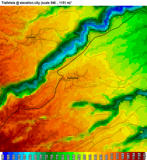
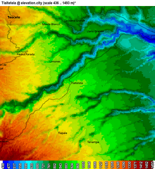
Below is the Elevation map of Tlaltetela, which displays elevation range with different colors. Scale of the first map is from 546 to 1151 m (1791 to 3776 ft) with average elevation of 915.3 meters (=3003 ft) [note 1]
These maps also provides idea of topography and contour of this city, they are displayed at different zoom levels. More info about maps, scale and edge coordinates you can find below images.
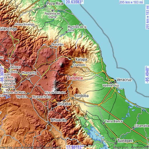
| \ | Map #1 | Map #2 | Topo.Map |
| Scale [m] | 546..1151 m | 436..1493 m | × |
| Scale [ft] | 1791..3776 ft | 1430..4898 ft | × |
| Average | 915.3 m = 3003 ft | 935.4 m = 3069 ft | × |
| Width | 9.22 km = 5.7 mi | 18.45 km = 11.5 mi | 295.1 km = 183.4 mi |
| Height | 9.22 km = 5.7 mi | 18.45 km = 11.5 mi | 295.1 km = 183.4 mi |
| ↑Max Latitude | 19.355677° | 19.397133° | 20.63583° |
| Latitude at center | 19.31421° | 19.31421° | 19.31421° |
| ↓Min Latitude | 19.272733° | 19.231245° | 17.98182° |
| ← Min Longitude | -96.944995° | -96.988941° | -98.3073° |
| Longitude center | -96.90105° | -96.90105° | -96.90105° |
| →Max Longitude | -96.857105° | -96.813159° | -95.4948° |
Nearby cities:
Cities around Tlaltetela sort by population:
• Teocelo elevation 1189 m
11 km,  316°
316°
• Tuzamapan 874 m
10.6 km,  21°
21°
• Cosautlán 1257 m
9.6 km,  281°
281°
• Mahuixtlan 979 m
10.7 km,  350°
350°
• Limones 977 m
3.5 km, 318°
• Tenampa 1021 m
7.5 km,  166°
166°
• Monte Blanco 997 m
7.7 km,  336°
336°
• Mata de Indio 902 m
11.2 km,  146°
146°
• Piedra Parada 1083 m
7.2 km,  300°
300°
• Llano Grande 836 m
6.6 km, 19°
• Tlapala 1104 m
6.1 km,  197°
197°
• Coyolito 996 m
10.1 km,  161°
161°
Multilingual:
 En español:
Tlaltetela elevación 977 m.
 En France:
Tlaltetela élévation 977 m.
 Auf Deutsch:
Tlaltetela höhe über dem Meeresspiegel ist 977 m.

Sources and notes:
- [note 1] Map square and city borders are not equal. Map elevation data is calculated only from area inside that square.
- [src 1] Elevation data from geonames database provided with same terms of usage.
- [src 2] The elevation map of Tlaltetela is generated using elevation data from NASA's 3 arcsec (90m) resolution SRTM data.
- [src 3] Base (background) map © OpenStreetMap contributors tiles are generated by Geofabrik and OpenTopoMap.
Copyright & License:
This Tlaltetela Elevation Map is licensed under CC BY-SA. You may reuse any part from this page, if you give a proper credit by linking to this URL:
 More info on terms of use page.